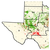
الحوض البرمي (أمريكا الشمالية)
| الحوض الپرمي Permian Basin | |
|---|---|
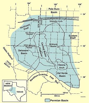 الحوض الپرمي في غرب تكساس. | |
| الإحداثيات | 32°30′N 103°00′W / 32.500°N 103.000°W |
| أصل التسمية | العصر الپرمي |
| الموقع | جنوب شرق أمريكا الشمالية |
| البلد | |
| الولايات | تكساس ونيومكسيكو |
| المدن | ميدلاند، اوديسا |
| Characteristics | |
| بري/بحري | بري |
| الحدود | متادور أرتش (الشمال) Ouachita–Marathon thrust belt (الجنوب) |
| المساحة | >220.000 كم² |
| الهيدرولوجيا | |
| الأنهار | نهر پكوس |
| Geology | |
| نوع الحوض | Cratonic basin (بالي وسنلسون) Interior sag basin (كنگستون وزملائه) Intracontinental complex basin (Klemme) |
| التجبل | هرسينيان |
| العمر | الپنسلڤاني-الگوادالوپي |
| علم طبقات الأرض | الطبقات |
| الحقول | الحقول |
الحوض الپرمي، هو حوض رسوبي ضخم يقع في الجزء الجنوبي الغربي من الولايات المتحدة. يحتوي الحوض على منطقة حقل ميد-كونتينت للنفط. يقع هذا الحوض الرسوبي في غرب تكساس وجنوب شرق نيومكسيكو. ويصل من جنوب لوبوك، ويمر عبر ميدلاند واوديسا، إلى الجنوب حتى نهر ريو گراند بجنوب غرب تكساس الوسطى، ويمتد غرباً عبر الجزء الجنوبي الشرقي من نيومكسيكو. سُمي بهذا الاسم لأنه يحتوي على واحدة من أسمك ودائع الصخور في العالم والتي يرجع عمرها إلى العصر الپرمي. يتالف الحوض الپرمي الأكبر من عدة أحواض، وحوض مارفا هو أصغرها. يغطي الحوض الپرمي مساحة تتجاوز 200.000 كم²،[1] ويمتد بعرض 400 كم وبطول 480 كم تقريباً.[2]
يعطي الحوض الپرمي اسمه إلى منطقة ضخمة لإنتاج النفط والغاز الطبيعي، وهي جزء من منطقة ميد-كونتينت لإنتاج النفط. بدءاً من 1993 كان إجمالي إنتاج النفط في المنطقة أكثر من 14.9 بليون برميل نفط. تخدم مدن ميدلاند، تكساس، اوديسا، تكساس وسان أنجلو، تكساس كمقرات رئيسية لأنشطة إنتاج النفط في الحوض.
كما يعتبر الحوض الپرمي مصدراً أساسياً لأملاح الپوتاسيوم (البوتاس)، الذي يتم تعدينه من ودائع السيلڤيت واللانگبينيت في تكوين سالدو الذي من العصر الپرمي . اكتشف السيلڤيت في بؤر الحفر عام 1925، وبدأ إنتاجه عام 1931. تقع المناجم في مقاطعتي ليا وإدي، نيومكسيكو، وتشغل بطريقة الغرفة والعمود. يُنتج الهاليت (ملح صخري) كمنتج ثانوي لتعدين البوتاس.[3][4][5][6]
المكونات
حوض ديلاوير
The Delaware Basin is the larger of the two major lobes of the Permian Basin within the foreland of the Ouachita–Marathon thrust belt separated by the Central Basin Platform. The basin contains sediment dating to Pennsylvanian, Wolfcampian (Neal Ranch and Lenox Hills Formations[7]), Leonardian (Avalon Shale), and early Guadalupian times. The eastward-dipping Delaware basin is subdivided into several formations (figure 2) and contains about 25،000 أقدام (7،600 m) of laminated siltstone and sandstone. Aside from clastic sediment, the Delaware basin also contains carbonate deposits of the Delaware Mountain Group, originating from the Guadalupian times when the Hovey Channel allowed access from the sea into the basin.[5]
حوض ميدلاند
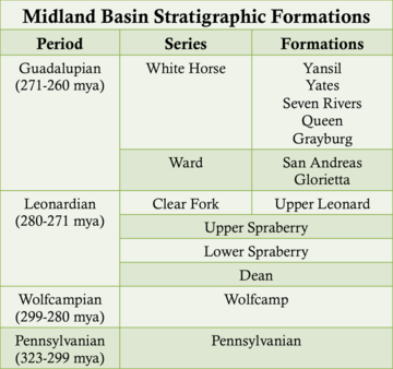
The westward-dipping Midland Basin is subdivided into several formations (figure 4) and is composed of laminated siltstone and sandstone. The Midland Basin was filled by a large subaqueous delta that deposited clastic sediment into the basin. Aside from clastic sediment, the Midland Basin also contains carbonate deposits originating from the Guadalupian times when the Hovey Channel allowed access from the sea into the basin.[5]
منصة الحوض الأوسط
الأرفف الشرقية والشمالية الغربية
قناة سان سيمون
قناة شفيلد
قناة هوڤي
أتول حدوة الحصان
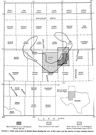
التاريخ الرسوبي
The Permian Basin is the thickest deposit of Permian aged rocks on Earth which were rapidly deposited during the collision of North America and Gondwana (South America and Africa) between the late Mississippian through the Permian. The Permian Basin also includes formations that date back to the Ordovician Period, 445 million years ago (mya).
الدهر الپروتيروزوي
Prior to the breakup of the Precambrian supercontinent and the formation of the modern Permian Basin geometry, shallow marine sedimentation onto the ancestral Tobosa Basin characterized the passive margin, shallow marine environment. The Tobosa Basin also contains basement rock that dates back to 1330 million years ago (mya), and that is still visible in the present-day Guadalupe Mountains. The basement rock contains biotite-quartz granite, discovered at a depth of 12،621 أقدام (3،847 m).[11] In the nearby Apache and Glass Mountains, the basement rock is made of metamorphosed sandstone and Precambrian-aged granite. The entire area is also underlain by layered mafic rocks, which are thought to be a part of Pecos Mafic Igneous Suite,[12] and extends 220 ميل (360 km) into the southern US. It has been dated to 1163 mya.
أوائل-وسط حقبة الحياة القديمة (أواخر الكمبري حتى المسيسيپي)
العصر الاُردوڤيشي (485.4 - 443.8 م.س.م)
Each period from the Paleozoic Era has contributed a specific lithology to the Tobosa Basin, accumulating into almost 6،600 أقدام (2،000 m) of sediment at the start of the Pennsylvanian Period (323.2–298.9 mya).[11] The Montoya Group is the youngest rock formation in the Tobosa Basin and was formed in the Ordovician Period (485.4–443.8 mya), and sit directly on the igneous and metamorphic basement rocks. The rocks from the Montoya Group are described as light to medium grey, fine to medium grained crystalline calcareous dolomite. These rocks were sometimes inter-bedded with shale, dark grey limestone, and, less commonly, chert. the Montoya Group sequence is made up of carbonate limestone and dolomite which is described as dense, impermeable, and non-porous, and is more commonly found in the Glass Mountains outcrop, with thickness varying from 151 إلى 509 أقدام (46 إلى 155 m).[11]
العصر السيلوري (443.8 – 419.2 م.س.م)
During the Silurian Period, the Tobosa Basin experienced dramatic changes in sea level which led to the formation of multiple rock groups. The first of these groups, called the Fusselman Formation, is mostly made up of light grey, medium to coarse grained dolomite. The thickness of this formation varies from 49 إلى 164 أقدام (15 إلى 50 m), and parts of the Fusselman Formation were also subject to karstification, which indicates a drop in sea level. The second rock group that formed during the Silurian Period is called the Wristen Formation, which is mud, shale, and dolomite rich rock that reaches a thickness of 1،480 أقدام (450 m) in some places. Karstification of the Fusselman Formation shows that a drop in sea level occurred, but sea levels rose again during a transgressive event, which lead to the creation of the Wristen Formation. Sea levels would then drop again, which led to major exposure, erosion, and karstification of these formations.[11]
العصر الديڤوني (419.2 - 358.9 م.س.م)
The Thirtyone Formation was developed during the Devonian Period. This formation is characterized by its limestone, chert, and shale beds, some of which had a peak thickness of 980 أقدام (300 m). this formation had many different types of limestone, including light-colored siliceous, chert-dominated, crinoid-rich, and sandy limestone. The Thirtyone Formation is very similar to the formation of the Mississippian Period, which is likely because there was little to no change in the environment during this time.[11]
عصر المسيسيپي (358.9 - 323.2 م.س.م)
أواخر حقبة الحياة القديمة (الپنسلڤاني- الپرمي)
العصر الپنسلڤاني (323.2 - 298.9 م.س.م)
العصر الپرمي (298.9 - 251 م.س.م)
الدهر الگوادلوپي (272.3 - 259.8 م.س.م)
الأقسام الظاهرة المعممة للحوض الپرمي
قسم أنظمة لوستاند
قسم أنظمة ترانسگرسيڤ
قسم أنظمة هايستاند
التاريخ التكتوني
During the Cambrian–Mississippian, the ancestral Permian Basin was the broad marine passive margin Tobosa Basin containing deposits of carbonates and clastics. In the early Pennsylvanian–early Permian the collision of North American and Gondwana Land (South America and Africa) caused the Hercynian orogeny. The Hercynian Orogeny resulted in the Tobosa basin being differentiated into two deep basins (the Delaware and the Midland Basins) surrounded by shallow shelves. During the Permian, the basin became structurally stable and filled with clastics in the basin and carbonates on the shelves.[13]
Lower Paleozoic passive margin phase (late Precambrian–Mississippian, 850–310 Mya)
This passive margin succession is present throughout the southwestern US and is up to 0.93 ميل (1.50 km) thick. The ancestral Permian basin is characterized by weak crustal extension and low subsidence in which the Tobosa basin developed. The Tobosa basin contained shelf carbonates and shales.[14]
Collision phase (late Mississippian–Pennsylvanian, 310–265 Mya)
The two lobed geometry of the Permian basin separated by a platform was the result of the Hercynian collisional orogeny during the collision of North America and Gondwana Land (South America and Africa). This collision uplifted the Ouachita-Marathon fold belt and deformed the Tobosa Basin. The Delaware Basin resulted from tilting along areas of Proterozoic weakness in Tobosa basin. Southwestern compression reactivated steeply dipping thrust faults and uplifted the Central Basin ridge. Folding of the basement terrane split the basin into the Delaware basin to the west and the Midland Basin to the east.[13][15]
Permian Basin phase (Permian, 265–230 Mya)
Rapid sedimentation of clastics, carbonate platforms and shelves, and evaporites proceeded synorogenically. Bursts of orogenic activity are divided by three angular unconformities in basin strata. Evaporite deposits in the small remnant basin mark the final stage of sedimentation as the basin became restricted from the sea during sea level fall.[14][16]
إنتاج وإحتياطيات الهيدروكربون

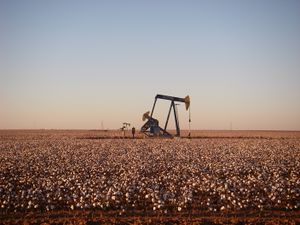
The Permian Basin is the largest petroleum-producing basin in the United States and has produced a cumulative 28.9 billion barrels of oil and 75 trillion cubic feet of gas. In early 2020, over 4 million barrels of oil a day are being pumped from the basin. Eighty percent of estimated reserves are located at less than 10،000 أقدام (3،000 m) depth. Ten percent of the oil recovered from the Permian Basin has come from Pennsylvanian carbonates. The largest reservoirs are within the Central Basin Platform, the Northwestern and Eastern shelves, and within Delaware Basin sandstones. The Primary lithologies of the major hydrocarbon reservoirs are limestone, dolomite, and sandstone due to their high porosities. However, advances in hydrocarbon recovery such as horizontal drilling and hydraulic fracturing have expanded production into unconventional, tight oil shales such as those found in the Wolfcamp Shale.[6][17]
تاريخ الموارد
In 1917, J.A. Udden, a University of Texas geology professor, speculated that the Marathon Fold, associated with the Marathon Mountains, may extend northward. This fold theory was further elaborated on in 1918 by geologists R.A. Liddle and J.W. Beede. The potential structure was thought to be a potential trap for oil. Based on this Marathon Fold theory, and known oil seeps, test drilling commenced in the eastern Permian Basin.[18]
Oil reserves in the Permian Basin were first documented by W.H Abrams in Mitchell County, West Texas in 1920. The first commercial well was opened a year later in 1921, in the newly discovered Westbrook Oil Field in Mitchell County, at a depth of 2،498 أقدام (761 m). Initially, the Permian Basin was thought to have a bowl-like shape, with geological survey crews unable to study the inside of the basin due to a lack of outcrops. The next few years contained discoveries of multiple oil fields, such as the Big Lake oil field (1923), the World oil field (1925), the McCamey oil field (1925), the Hendrick oil field (1926), and the Yates Oil Field (1926). All of these discoveries were made by random drilling or surfacing mapping. Geophysical tests were vital in mapping the region, since tools such as seismographs and magnetometers were used to find anomalies in the area.[18][19]
By 1924, companies establishing regional geological offices in the basin included the California Company (Standard Oil of California), Gulf Oil, Humble (Standard Oil of New Jersey), Roxana (Shell Oil Company), Dixie Oil (Standard Oil of Indiana), Midwest Exploration (Standard Oil of Indiana), and The Texas Company.[18]
Due to distances and lack of pipes in which to move oil, deep drilling tests were few in the 1920s, since the costs were high. As a result, all the oil wells up to 1928 were less than 5،000 أقدام (1،500 m) or 6،000 أقدام (1،800 m) deep. However, in 1928, the No. I-B University discovery well found oil at 8,520 feet within the Ordovician formations of Big Lake. Exploration and development increased in the 1930s with the discovery of the Harper oil field (1933), the Goldsmith oil field (1934), the Foster oil field (1935), the Keystone oil field (1935), the Means oil field (1934), the Wasson oil field (1936–1937), and the Slaughter Field (1936). During World War II the need for oil in the US became urgent, justifying the high costs of deep oil drilling. This breakthrough led to major oil reservoirs being found in every geological formation from the Cambrian Period to the Permian Period. Significant discoveries included the Embrar oil field (1942), the TXL oil field (1944), the Dollarhide oil field (1945), and the Block 31 oil field (1945).[18][19]
In 1966, the production of the Permian Basin measured 600 million barrels of oil, along with 2.3 trillion cubic ft of gas, which totaled $2 billion. The production values steadily increased thanks to the installation of gas pipelines and oil refineries in the area, reaching a total production of over 14.9 billion barrels in 1993.
In addition to oil, one of the main commodities that is mined from the Permian Basin is potash, which was first discovered in the region in the late 1800s by geologist Johan August Udden. Early studies by Udden, and the presence of potash in the Santa Rita well between 1100 and 1700 feet, led to the United States Geological Survey exploring the area in search of potash, which was highly important during World War I as the US could no longer import it from Germany. By the mid 1960s, seven potash mines were operating on the New Mexico side of the Permian Basin.[19][20]
الإنتاج الحالي
اعتبارا من 2018[تحديث], the Permian Basin has produced more than 33 billion barrels of oil, along with 118 trillion cubic feet of natural gas. This production accounts for 20% of US crude oil production and 7% of US dry natural gas production. While the production was thought to have peaked in the early 1970s, new technologies for oil extraction, such as hydraulic fracturing and horizontal drilling, have increased production dramatically. Estimates from the Energy Information Administration have predicted that proven reserves in the Permian Basin still hold 5 billion barrels of oil and approximately 19 trillion cubic feet of natural gas.[21]
المخاوف البيئية
By October 2019, the fossil-fuel executives said that until recently they had been making progress in cutting back on flaring, which is to burn natural gas.[22] Drilling companies focus on drilling and pumping oil, which is highly lucrative but the less-valuable gas which is pumped along with the oil, is considered to be a "byproduct".[22] During the current boom in the Permian oil fields, drilling for oil has "far outpaced pipeline construction" so the use of flaring has increased along with venting "natural gas and other potent greenhouse gases directly into the atmosphere", causing considerably larger greenhouse effect than flaring. Both practices are legal under states' legislation.[22] Most of the methane emitted comes from a small number of sources.[23] Satellite data show that 3.7% of gas produced from the Permian Basin is lost in leaks, equivalent to the consumption of 7 million Texas homes.[24] The price of natural gas was so cheap that smaller companies that have the pipeline capacity are choosing to flare rather than pay pipeline costs.[22]
مقاطعات الحوض الپرمي
- مقاطعة أندروس السكان: 14.057
- مقاطعة بوردن السكان: 525
- مقاطعة كران السكان: 4.165
- مقاطعة داوسون السكان: 13.657
- مقاطعة إكتور السكان: 134.165
- مقاطعة إدي، نيومكسيكو السكان: 52.706
- مقاطعة گينز السكان: 15.382
- مقاطعة گلاسكوك السكان: 1.406
- مقاطعة هوارد السكان: 32.940
- مقاطعة ليو، نيومكسيكو السكان: 60.232
- مقاطعة لڤنگ السكان: 113
- مقاطعة مارتن السكان: 4.581
- مقاطعة ميدلاند السكان: 132.316
- مقاطعة پيكوس السكان: 16.248
- مقاطعة ريڤز السكان: 11.046
- مقاطعة ترل السكان: 969
- مقاطعة أپتون السكان: 3.130
- مقاطعة وارد السكان: 10.528
- مقاطعة وينكلر السكان: 6.772
- مقاطعة يواكوم السكان: 7.698
حسب تعداد 2008/2009، كان إجمالي سكان الحوض الپرمي 522.568 نسمة.
مقاطعات تعتبر أحياناً ضمن الحوض البرمي:
- مقاطعة بروستر السكان: 9.489
- مقاطعة كوركت السكان: 3.740
- مقاطعة كبلرسون السكان: 2.300
- مقاطعة جف ديڤيز السكان: 2.258
- مقاطعة كنت السكان: 807
- مقاطعة متشل السكان: 9.347
- مقاطعة پرسيديو السكان: 7.470
- مقاطعة ريگان السكان: 3.014
- مقاطعة سكري السكان: 16.222
- مقاطعة سترلنگ السكان: 1.259
عند تضمين هذه المقاطعات، فإن عدد سكان الحوض الپرمي يصل إلى 577.667 نسمة.
انظر أيضاً
- قائمة المناطق الجيولوجية في تكساس
- جامعة تكساس للحوض الپرمي
- متحف الحوض الپرمي للنفط
- Permian Basin (Europe)
- حقل سلوتر
- حوض ڤال ڤردي
- Spraberry Trend
المصادر
- ^ Ball - The Permian Basin - USGS
- ^ Permian Basin map at Department of Energy, National Energy Lab
- ^ B. R. Alto and R. S. Fulton (1965) "Salines" and "The potash industry" in Mineral and Water Resources of New Mexico, New Mexico Bureau of Mines and Mineral Resources, Bulletin 87, p.299–309.
- ^ Galley, John (1995). "Oil and Geology in the Permian Basin of Texas and New Mexico".
{{cite journal}}: Cite journal requires|journal=(help) - ^ أ ب ت Ward, R.F.; et al. (1986). "Upper Permian (Guadalupian) facies and their association with hydrocarbons-Permian basin, west Texas and New Mexico". AAPG Bulletin. 70: 239–262. doi:10.1306/9488566f-1704-11d7-8645000102c1865d.
- ^ أ ب Wright, Wayne (2011). "Pennsylvanian paleodepositional evolution of the greater Permian Basin, Texas and New Mexico: Depositional systems and hydrocarbon reservoir analysis". AAPG Bulletin. 95 (9): 1525–1555. Bibcode:2011BAAPG..95.1525W. doi:10.1306/01031110127.
- ^ Ross, C.A. (1959). "The Wolfcamp Series (Permian) and new species of fusulinids, Glass Mountains, Texas". Washington Academy of Sciences Journal. 49 (9): 299–316. JSTOR 24534755.
- ^ Stafford, P. T., 1959, Geology of Part of the Horseshoe Atoll in Scurry and Kent Counties, Texas, USGS Professional Paper 315-A, Washington: US Dept. of Interior, p. 2.
- ^ Stafford, P. T., 1959, Geology of Part of the Horseshoe Atoll in Scurry and Kent Counties, Texas, USGS Professional Paper 315-A, Washington: US Dept. of Interior, p. 6.
- ^ Stafford, P. T., 1959, Geology of Part of the Horseshoe Atoll in Scurry and Kent Counties, Texas, USGS Professional Paper 315-A, Washington: US Dept. of Interior, p. 8.
- ^ أ ب ت ث ج خطأ استشهاد: وسم
<ref>غير صحيح؛ لا نص تم توفيره للمراجع المسماة:0 - ^ "1000 Ma large mafic magmatic events". Large Igneous Provinces Commission. Retrieved 12 April 2019.
- ^ أ ب Hills, J.M. (1984). "Sedimentation, tectonism, and hydrocarbon generation in the Delaware basin, West Texas and Southeastern New Mexico". AAPG Bulletin. 68: 250–267. doi:10.1306/ad460a08-16f7-11d7-8645000102c1865d.
- ^ أ ب Horak, R.L. (May 27, 1985). "Tectonic and hydrocarbon maturation history in the Permian basin". Oil and Gas Journal: 124–129.
- ^ Sarg, J.; et al. (1999). "The second-order cycle, carbonate-platform growth, and reservoir, source, and trap prediction, Advances in carbonate sequence stratigraphy: Application to reservoirs, outcrops and models". SEPM Special Publication. 63: 11–34.
- ^ Hoak, T; et al. (1991). "Overview of the Structural Geology and Tectonics of the Central Basin Platform, Delaware Basin, and Midland Basin, West Texas and New Mexico". Department of Energy Publication.
- ^ Dutton, S.P.; et al. (2005). "Play analysis and leading edge oil-reservoir development methods in the Permian Basin; increased recovery through advanced technologies". AAPG Bulletin. 89 (5): 553–576. Bibcode:2005BAAPG..89..553D. doi:10.1306/12070404093. S2CID 231697417.
- ^ أ ب ت ث Olien, Diana; Olien, Roger (2002). Oil in Texas, The Gusher Age, 1895-1945. Austin: University of Texas Press. pp. 147–158. ISBN 0292760566.
- ^ أ ب ت Vertrees, Charles D. (2010-06-15). "Permian Basin". Handbook of Texas Online. Retrieved 12 April 2019 – via Texas State Historical Association.
- ^ Schwettmann, Martin (1943). Santa Rita, The University of Texas Oil Discovery. The Texas State Historical Association. p. 27. ISBN 9780876110188.
- ^ US Department of Energy (November 2018). "Permian Basin Geology Review" (PDF). Archived (PDF) from the original on February 26, 2021.
- ^ أ ب ت ث Tabuchi, Hiroko (October 16, 2019). "Despite Their Promises, Giant Energy Companies Burn Away Vast Amounts of Natural Gas". The New York Times. ISSN 0362-4331. Archived from the original on June 5, 2021. Retrieved October 17, 2019.
- ^ "TEXAS: The key to oil and gas methane emission cuts? 123 leaks". www.eenews.net (in الإنجليزية). June 4, 2021. Archived from the original on June 4, 2021.
- ^ Storrow, Benjamin (5 May 202). "Methane Leaks Erase Some of the Climate Benefits of Natural Gas". Scientific American (in الإنجليزية). Archived from the original on 27 April 2022.
وصلات خارجية
- Permian Basin—Texas State Historical Association article
- Articles with hatnote templates targeting a nonexistent page
- Pages using gadget WikiMiniAtlas
- مقالات فيها عبارات متقادمة منذ 2018
- جميع المقالات التي فيها عبارات متقادمة
- أحواض رسوبية في أمريكا الشمالية
- العصر الفحمي في الولايات المتحدة
- الولايات المتحدة في العصر الپرمي
- مناطق جيولوجية في تكساس
- مناطق نيومكسيكو
- مناطق تكساس
- جيولوجيا العصر الفحمي في نيومكسيكو
- جيولوجيا العصر الفحمي في تكساس
- جيولوجيا العصر الپرمي في نيومكسيكو
- جيولوجيا العصر الپرمي في تكساس
- حقول نفط في الولايات المتحدة
- حقول نفط في تكساس



![التسلسل الطبقي لهورس شو أتول[9]](/w/images/thumb/f/fa/Horseshoe_Atoll_Stratigraphic_sequence.jpg/108px-Horseshoe_Atoll_Stratigraphic_sequence.jpg)


