مقاطعة سان ميگل، نيومكسيكو
San Miguel County | |
|---|---|
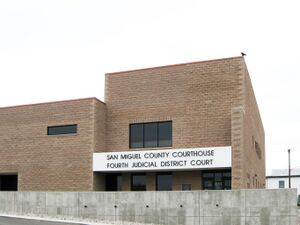
 San Miguel County Courthouse in Las Vegas | |
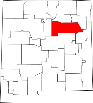
 الموقع ضمن ولاية New Mexico | |
 موقع New Mexico ضمن الولايات المتحدة | |
| الإحداثيات: 35°28′N 104°50′W / 35.47°N 104.83°W | |
| البلد | |
| State | |
| تأسست | January 9, 1852 |
| السمِيْ | سان ميگل دل ڤادو |
| Seat | Las Vegas |
| Largest city | Las Vegas |
| المساحة | |
| • الإجمالي | 4٬736 ميل² (12٬270 كم²) |
| • البر | 4٬716 ميل² (12٬210 كم²) |
| • الماء | 20 ميل² (50 كم²) 0.4%% |
| التعداد | |
| • Estimate (2019) | 27٬277 |
| • الكثافة | 6٫2/sq mi (2٫4/km2) |
| منطقة التوقيت | UTC−7 (Mountain) |
| • الصيف (التوقيت الصيفي) | UTC−6 (MDT) |
| Congressional district | 3rd |
| الموقع الإلكتروني | co |
مقاطعة سان ميگل إنگليزية: San Miguel County هي إحدى مقاطعات ولاية نيومكسيكو في الولايات المتحدة. As of the 2010 census, the population was 29,393.[1] Its county seat is Las Vegas.[2]
San Miguel County comprises the Las Vegas, NM Micropolitan Statistical Area, which is also included in the Albuquerque-Santa Fe-Las Vegas, NM Combined Statistical Area.
. . . . . . . . . . . . . . . . . . . . . . . . . . . . . . . . . . . . . . . . . . . . . . . . . . . . . . . . . . . . . . . . . . . . . . . . . . . . . . . . . . . . . . . . . . . . . . . . . . . . . . . . . . . . . . . . . . . . . . . . . . . . . . . . . . . . . . . . . . . . . . . . . . . . . . . . . . . . . . . . . . . . . . . .
الجغرافيا
According to the U.S. Census Bureau, the county has a total area of 4,736 square miles (12,270 km2), of which 4,716 square miles (12,210 km2) is land and 20 square miles (52 km2) (0.4%) is water.[3]
المقاطعات المجاورة
- Mora County - north
- Harding County - east
- Quay County - southeast
- Guadalupe County - south
- Torrance County - southwest
- Santa Fe County - west
National protected areas
- Las Vegas National Wildlife Refuge
- Pecos National Historical Park (part)
- Santa Fe National Forest (part)
الديمغرافيا
| التعداد التاريخي | |||
|---|---|---|---|
| التعداد | Pop. | %± | |
| 1910 | 22٬930 | — | |
| 1920 | 22٬867 | −0٫3% | |
| 1930 | 23٬636 | 3٫4% | |
| 1940 | 27٬910 | 18٫1% | |
| 1950 | 26٬512 | −5�0% | |
| 1960 | 23٬468 | −11٫5% | |
| 1970 | 21٬951 | −6٫5% | |
| 1980 | 22٬751 | 3٫6% | |
| 1990 | 25٬743 | 13٫2% | |
| 2000 | 30٬126 | 17�0% | |
| 2010 | 29٬393 | −2٫4% | |
| 2019 (تق.) | 27٬277 | [4] | −7٫2% |
| U.S. Decennial Census[5] 1790-1960[6] 1900-1990[7] 1990-2000[8] 2010-2016[1] | |||
التجمعات
المدينة
- Las Vegas (مقر المقاطعة)
القرى
Census-designated places
Other communities
- Bernal
- El Porvenir
- Garita
- Holy Ghost
- Ilfeld
- Montezuma
- Rociada
- San Miguel del Vado
- Sapello
- Serafina
- South San Ysidro
- Tererro
- Trementina
- Valles de San Geronimo
البلدة المهجورة
أشخاص بارزون
- Antonia Apodaca (1923–2020) born in Rociada, folk musician and composer
- Margaret Larkin (1899–1967), born in Las Vegas, writer and musician
السياسة
San Miguel County is heavily Democratic. The last time it voted Republican for president was 1956, and since 1992 no Republican has cracked 30% of the vote.
| Year | Republican | Democratic | Third parties |
|---|---|---|---|
| 2020 | 29.7% 3,421 | 68.4% 7,888 | 1.9% 222 |
| 2016 | 21.5% 2,313 | 67.8% 7,285 | 10.7% 1,153 |
| 2012 | 20.0% 2,303 | 76.9% 8,850 | 3.1% 356 |
| 2008 | 19.2% 2,478 | 79.8% 10,320 | 1.1% 143 |
| 2004 | 27.3% 3,313 | 71.7% 8,683 | 1.0% 120 |
| 2000 | 24.2% 2,215 | 71.4% 6,540 | 4.4% 406 |
| 1996 | 20.1% 1,938 | 72.5% 6,995 | 7.4% 714 |
| 1992 | 23.3% 2,183 | 65.9% 6,186 | 10.8% 1,018 |
| 1988 | 30.6% 2,763 | 68.0% 6,131 | 1.4% 129 |
| 1984 | 39.4% 3,485 | 59.1% 5,227 | 1.6% 138 |
| 1980 | 39.3% 3,292 | 53.9% 4,514 | 6.7% 563 |
| 1976 | 37.2% 3,162 | 61.2% 5,204 | 1.7% 141 |
| 1972 | 47.7% 4,434 | 50.2% 4,663 | 2.1% 196 |
| 1968 | 48.1% 4,027 | 48.9% 4,088 | 3.0% 253 |
| 1964 | 31.9% 2,714 | 67.8% 5,767 | 0.3% 24 |
| 1960 | 41.9% 3,988 | 58.0% 5,520 | 0.1% 6 |
| 1956 | 55.9% 5,083 | 44.1% 4,014 | 0.0% 3 |
| 1952 | 54.6% 5,360 | 45.3% 4,451 | 0.1% 7 |
| 1948 | 48.3% 4,655 | 51.4% 4,953 | 0.2% 21 |
| 1944 | 46.1% 4,014 | 53.8% 4,684 | 0.1% 4 |
| 1940 | 44.6% 4,882 | 55.3% 6,054 | 0.1% 7 |
| 1936 | 43.1% 4,697 | 56.8% 6,199 | 0.1% 10 |
| 1932 | 51.3% 5,364 | 48.5% 5,076 | 0.2% 20 |
| 1928 | 59.3% 5,184 | 40.7% 3,560 | 0.1% 4 |
| 1924 | 50.6% 3,894 | 46.0% 3,543 | 3.4% 265 |
| 1920 | 58.1% 5,535 | 41.9% 3,990 | |
| 1916 | 56.4% 2,932 | 42.9% 2,231 | 0.7% 38 |
| 1912 | 55.7% 2,479 | 39.1% 1,740 | 5.3% 234 |
. . . . . . . . . . . . . . . . . . . . . . . . . . . . . . . . . . . . . . . . . . . . . . . . . . . . . . . . . . . . . . . . . . . . . . . . . . . . . . . . . . . . . . . . . . . . . . . . . . . . . . . . . . . . . . . . . . . . . . . . . . . . . . . . . . . . . . . . . . . . . . . . . . . . . . . . . . . . . . . . . . . . . . . .
انظر أيضاً
- National Register of Historic Places listings in San Miguel County, New Mexico
- San Miguel del Vado Land Grant
المراجع
- ^ أ ب "State & County QuickFacts". United States Census Bureau. Archived from the original on July 18, 2011. Retrieved September 30, 2013.
- ^ "Find a County". National Association of Counties. Retrieved June 7, 2011.
- ^ "2010 Census Gazetteer Files". United States Census Bureau. أغسطس 22, 2012. Archived from the original on يناير 1, 2015. Retrieved يناير 2, 2015.
- ^ "Population and Housing Unit Estimates". Retrieved December 23, 2019.
- ^ "U.S. Decennial Census". United States Census Bureau. Retrieved January 2, 2015.
- ^ "Historical Census Browser". University of Virginia Library. Retrieved January 2, 2015.
- ^ "Population of Counties by Decennial Census: 1900 to 1990". United States Census Bureau. Retrieved January 2, 2015.
- ^ "Census 2000 PHC-T-4. Ranking Tables for Counties: 1990 and 2000" (PDF). United States Census Bureau. Retrieved January 2, 2015.
- ^ Leip, David. "Dave Leip's Atlas of U.S. Presidential Elections". uselectionatlas.org. Retrieved 2018-04-02.
وصلات خارجية

|
Mora County | 
| ||
| Harding County | Santa Fe County | |||
| Quay County | Guadalupe County | Torrance County |
- Pages using gadget WikiMiniAtlas
- Short description is different from Wikidata
- Coordinates on Wikidata
- مقاطعات New Mexico
- Articles containing إنگليزية-language text
- Pages using Lang-xx templates
- Pages using US Census population needing update
- Official website different in Wikidata and Wikipedia
- مقاطعة سان ميگل، نيومكسيكو
- 1852 establishments in New Mexico Territory
- Populated places established in 1852
- مقاطعات ولاية نيومكسيكو الأمريكية
