نبكة
| الموائل البحرية |
|---|
 |
| الموائل الساحلية |
| سطح المحيط |
| المحيط المفتوح |
| قاع البحر |
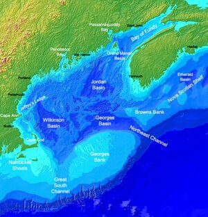
النبكة[1] ocean bank ، أحياناً يشار إليها بإسم نبكة صيد أو ببساطة نبكة bank، هي جزء من البحر يكون ضحلاً بالمقارنة بالمنطقة المحيطة، مثل shoal أو قمة ربوة تحت الماء. Somewhat like continental slopes، ocean banks slopes can upwell as tidal and other flows intercept them، resulting sometimes in nutrient rich currents.قالب:How بسبب ذلك، فبعض النبكات الكبرى، مثل نبكة دوگر ونبكات نيوفاوندلاند الكبرى، هم بين أغنى مصايد الأسماك في العالم.
وهناك بعض النبكات التي وصفها بحارة في القرن 19، مثل Wachusett Reef، التي كان وجودها مشكوك فيه.
الأنواع
Ocean banks may be of volcanic nature. Banks may be carbonate or terrigenous. In tropical areas some banks are submerged atolls. As they are not associated with any landmass، banks have no outside source of sediments. Carbonate banks are typically platforms، rising from the ocean depths، whereas terrigenous banks are elevated sedimentary deposits.[2]
الجبال تحت البحر، بالمقارنة، هم جبال، ذات أصل بركاني، ترتفع من قاع البحر العميق، ويكونوا أكثر انحداراً، وأعلى بالمقارنة بـقاع البحر المحيط بها.[3] Examples of these are Pioneer and Guide Seamounts، west of the Farallon Islands. The Pioneer Seamount has a depth of 1,000 meters,[3] In other cases، parts of a bank may reach above the water surface، thereby forming islands.[4]
نبكات هامة
أكبر نبكات في العالم هي:
- نبكات نيوفاوندلاند الكبرى (280,000 كم²)[5] - terrigenous bank
- نبكة أگوليا (116,000 كم²)[6]
- نبكة باهاما الكبرى (95,798.12 كم²، has islands، area without islands)
- سايا دي ماليا (35,000 كم²، excluding the separate North bank، أقل عمق 7 م)
- نبكة سيشل (31,000 كم²، تضم جزر مساحتها 266 كم²)
- نبكة جورج (28,800 كم²) - terrigenous bank
- نبكة لاندزداون (21,000 كم²، west of New Caledonia، أقل عمق 3.7 m)
- نكبة دوگر (17,600 كم²، أقل عمق 13 م)
- نبكة باهاما الصغيرة (14,260.64 كم²، فيها جزر، المساحة بدون الجزر)
- Great Chagos Bank (12,642 كم²، including islands of 4.5 كم²)
- نبكة ريد، جزر سپراتلي (8,866 كم²، أقل عمق 9 م)
- نبكة كيكوس، جزر كيكوس (7,680 كم²، تضم جزر مساحتها 589.5 كم²)
- نبكة ماكلزفيلد (6,448 كم²، أقل عمق 9.2 م)
- North Bank or Ritchie Bank (5,800 كم²، شمال سايا دي ماليا، أقل عمق <10 م)
- Cay Sal Bank (5,226.73 كم²، وتضم جزر مساحتها 14.87 كم²)
- نبكة روزاليند (4,500 كم²، أقل عمق 7.3 م)
- Bassas de Pedro (2,474.33 كم²، أقل عمق 16.4 m)، جزء من أمينديڤي المجموعة الفرعية ضمن لاكشادويپ، الهند
انظر أيضاً
الهامش
- ^ المورد الأكبر يترجم كلمة Bank بـ "نبكة" هي مرتفع في قاع نهر أو بحر، حيث يشكل الطين أو الرمل كتلة.
- ^ Morelock، J. (2005). Morphology. Geological Oceanography Program، University of Puerto Rico at Mayagüez (UPRM). Retrieved on: October 11، 2008.
- ^ أ ب Farallones Marine Sanctuary Association. Islands، Banks & Seamounts: Geologic Features Under the Sea.
- ^ World Wildlife Fund. Deep sea ecology: seamounts. Retrieved on: October 11، 2008.
- ^ Fisheries and Oceans Canada Backgrounder: The Grand Banks and the Flemish Cap. Retrieved on: October 11، 2008.
- ^ Whittle, C. P. (2012). "Characterization of Agulhas Bank upwelling variability from satellite-derived sea surface temperature and ocean colour products" (PDF). American Geophysical Union Chapman Conference. Retrieved January 2015.
{{cite web}}: Check date values in:|accessdate=(help)


