الجزر الشمالية
(تم التحويل من Northern Isles)
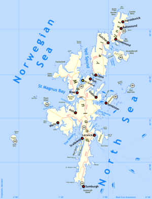
الجزر الشمالية Northern Isles (سكوتس: Northren Isles; غالية اسكتلندية: Na h-Eileanan a Tuath; نورسية القديمة: Norðreyjar)، هي سلسلة (أو أرخبيل) جزر قبالة الساحل الشمالي للبر الرئيسي الاسكتلندي. تتمتع الجزر الشمالية بمناخ بارد ومعتدل وتتأثر كثيراً بالبحار المحيطة. هناك مجموعتين رئيسيتين من الجزر: شتلاند واوركني. هناك 26 جزيرة غير مأهولة وأفق الجزر الزراعية الخصبة في اوركني المتناقضة مع طبيعة جزر شتلاند الوعرة في الشمال، حيث الاقتصاد يعتمد بصورة أكبر على الصيح وثروة النفط في البحار المحيطة. تقوم الجزيرتين بتطوير صناعة الطاقة المتجددة.
الجغرافيا
الجيولوجيا
المناخ
قبل التاريخ
التاريخ، الثقافة والسياسة

King Olav Tryggvason of Norway, who forcibly Christianised Orkney.[1] Painting by Peter Nicolai Arbo.
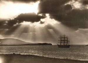
Full-rigged ship Maella, of Oslo, in Bressay Sound circa 1922
السياسة
النقل
الاقتصاد
الثقافة
أسماء الجزر
شتلاند
| الجزيرة | الاشتقاق | اللغة | المعنى | البدائل |
|---|---|---|---|---|
| Bressay | Breiðøy | Norse | broad island[2] | |
| Bruray | Norse | east isle[3] | Norse: bruarøy – bridge island"[3] | |
| East Burra | Scots/Norse | east broch island[4] | ||
| Fair Isle | Frioarøy | Norse | fair island[5] | Norse: feoerøy – "far-off isle".[5] |
| Fetlar | Unknown | Pre-Celtic? | Unknown | Norse: fetill – "shoulder-straps"[6] or "fat land".[7] See also Funzie Girt. |
| Foula | Fugløy | Norse | bird island[8] | |
| Housay | Húsøy | Norse | house isle[3] | |
| Shetland Mainland | Hetlandensis | Norse/ Gaelic | island of the cat people?[9] | Perhaps originally from Gaelic: Innse Chat – see above[9] |
| Muckle Roe | Rauðey Milkla | Scots/Norse | big red island[4] | |
| Papa Stour | Papøy Stóra | Celtic/Norse | big island of the priests[10] | |
| Trondra | Norse | boar island[11] | Norse: "Þrondr's isle" or "Þraendir's isle". The first is a personal name, the second a tribal name from the Trondheim area.[11] | |
| Unst | Unknown | Pre-Celtic? | Unknown | Norse: omstr – "corn-stack"[6] or ørn-vist – "home of the eagle"[12] |
| Vaila | Valøy | Norse | falcon island[13] | Norse: "horse island", "battlefield island" or "round island"[13] |
| West Burra | Scots/Norse | west broch island[4] | ||
| Whalsay | Hvalsey | Norse | whale island[14] | |
| Yell | Unknown | Pre-Celtic? | Unknown | Norse: í Ála – "deep furrow"[6] or Jala – "white island"[15] |
اوركني
| الجزيرة | الاشتقاق | اللغة | المعنى | البدائل |
|---|---|---|---|---|
| Auskerry | Østr sker | Norse | east skerry[16] | |
| Burray | Borgrøy | Norse | broch island[17] | |
| Eday | Eidøy | Norse | isthmus island[18] | |
| Egilsay | Égillsey | Norse or Gaelic | Egil's island[19] | Possibly from Gaelic eaglais" – church island[20] |
| Flotta | Flottøy | Norse | flat, grassy isle[21] | |
| Gairsay | Gáreksøy | Norse | Gárekr's isle[22] | |
| Graemsay | Grims-øy | Norse | Grim's island[23] | |
| Holm of Grimbister | Norse | Small and rounded islet of Grim's farm | ||
| Hoy | Háøy | Norse | high island[24] | |
| Inner Holm | English/Norse | inner rounded islet | ||
| North Ronaldsay | Rinansøy | Norse | Uncertain – possibly "Ringa's isle"[25] | |
| Orkney Mainland | Orcades | Various | isle(s) of the young pig[26] | See above |
| Papa Stronsay | Papey Minni | Norse | priest isle of Stronsay[27] | The Norse name is literally "little priest isle"[27] |
| Papa Westray | Papey Meiri | Norse | priest isle of Westray[28] | The Norse name is literally "big priest isle"[28] |
| Rousay | Hrólfsøy | Norse | Hrólfs island[29] | |
| Sanday | Sandøy | Norse | sand island[30] | |
| Shapinsay | Unknown | Possibly "helpful island"[31] | See above | |
| South Ronaldsay | Rognvaldsey | Norse | Rognvald's island[17] | |
| South Walls | Sooth Was | Scots/Norse | "southern voes" | "Voe" means fjord. Possibly "south bays". |
| Stronsay | Possibly Strjónsøy | Norse | good fishing and farming island[32] | |
| Westray | Vestrøy | Norse | western island[33] | |
| Wyre | Vigr | Norse | spear-like island[34] |
جزر غير مأهولة
المصادر
- الهوامش
- الحواشي
- ^ Thomson (2008) p. 69. quoting the Orkneyinga Saga chapter 12.
- ^ Haswell-Smith (2004) p. 425
- ^ أ ب ت Haswell-Smith (2004) p. 459
- ^ أ ب ت Haswell-Smith (2004) p. 433
- ^ أ ب Haswell-Smith (2004) p. 408
- ^ أ ب ت Gammeltoft (2010) pp. 19–20
- ^ Haswell-Smith (2004) p. 471
- ^ Haswell-Smith (2004) p. 419
- ^ أ ب خطأ استشهاد: وسم
<ref>غير صحيح؛ لا نص تم توفيره للمراجع المسماةG9 - ^ Haswell-Smith (2004) p. 449
- ^ أ ب Haswell-Smith (2004) p. 434
- ^ Haswell-Smith (2004) p. 481
- ^ أ ب Haswell-Smith (2004) p. 430
- ^ Haswell-Smith (2004) p. 452
- ^ Haswell-Smith (2004) p. 467
- ^ Haswell-Smith (2004) p. 363
- ^ أ ب Haswell-Smith (2004) p. 354
- ^ Haswell-Smith (2004) p. 386
- ^ Gammeltoft (2010) p. 16
- ^ Haswell-Smith (2004) p. 379
- ^ Haswell-Smith (2004) p. 341
- ^ Haswell-Smith (2004) p. 367
- ^ Haswell-Smith (2004) p. 352
- ^ Haswell-Smith (2004) p. 343
- ^ Haswell-Smith (2004) p. 400
- ^ خطأ استشهاد: وسم
<ref>غير صحيح؛ لا نص تم توفيره للمراجع المسماةW116 - ^ أ ب Haswell-Smith (2004) p. 376
- ^ أ ب Haswell-Smith (2004) p. 397
- ^ Haswell-Smith (2004) p. 383
- ^ Haswell-Smith (2004) p. 392
- ^ خطأ استشهاد: وسم
<ref>غير صحيح؛ لا نص تم توفيره للمراجع المسماةH364 - ^ Haswell-Smith (2004) p. 370
- ^ Haswell-Smith (2004) p. 394
- ^ Gammeltoft (2010) p. 18
- General references
- Armit, Ian (2006) Scotland's Hidden History. Stroud. Tempus. ISBN 0-7524-3764-X
- Ballin Smith, B. and Banks, I. (eds) (2002) In the Shadow of the Brochs, the Iron Age in Scotland. Stroud. Tempus. ISBN 0-7524-2517-X
- Clarkson, Tim (2008) The Picts: A History. Stroud. The History Press. ISBN 978-0-7524-4392-8
- قالب:Haswell-Smith
- Gammeltoft, Peder (2010) "Shetland and Orkney Island-Names – A Dynamic Group". Northern Lights, Northern Words. Selected Papers from the FRLSU Conference, Kirkwall 2009, edited by Robert McColl Millar.
- General Register Office for Scotland (28 November 2003) Occasional Paper No 10: Statistics for Inhabited Islands[dead link]. Retrieved 22 January 2011.
- Gillen, Con (2003) Geology and landscapes of Scotland. Harpenden. Terra Publishing. ISBN 1-903544-09-2
- Keay, J. & Keay, J. (1994) Collins Encyclopaedia of Scotland. London. HarperCollins. ISBN 0-00-255082-2
- قالب:Gaelic Placenames
- Omand, Donald (ed.) (2003) The Orkney Book. Edinburgh. Birlinn. ISBN 1-84158-254-9
- Nicolson, James R. (1972) Shetland. Newton Abbott. David & Charles.
- Sandnes, Berit (2003) From Starafjall to Starling Hill: An investigation of the formation and development of Old Norse place-names in Orkney. (pdf) Doctoral Dissertation, NTU Trondheim.
- Sandnes, Berit (2010) "Linguistic patterns in the place-names of Norway and the Northern Isles" Northern Lights, Northern Words. Selected Papers from the FRLSU Conference, Kirkwall 2009, edited by Robert McColl Millar.
- Schei, Liv Kjørsvik (2006) The Shetland Isles. Grantown-on-Spey. Colin Baxter Photography. ISBN 978-1-84107-330-9
- Shetland Islands Council (2010) "Shetland in Statistics 2010" (pdf) Economic Development Unit. Lerwick. Retrieved 6 March 2011
- Thomson, William P. L. (2008) The New History of Orkney Edinburgh. Birlinn. ISBN 978-1-84158-696-0
- Turner, Val (1998) Ancient Shetland. London. B. T. Batsford/Historic Scotland. ISBN 0-7134-8000-9
- Wickham-Jones, Caroline (2007) Orkney: A Historical Guide. Edinburgh. Birlinn. ISBN 1-84158-596-3
- Watson, W. J. (1994) The Celtic Place-Names of Scotland. Edinburgh. Birlinn. ISBN 1-84158-323-5. First published 1926.
الكلمات الدالة:
تصنيفات:
- Articles containing سكوتس-language text
- Pages using Lang-xx templates
- Articles containing غالية اسكتلندية-language text
- Articles containing نورسية القديمة-language text
- Articles with hatnote templates targeting a nonexistent page
- Articles with dead external links from May 2014
- أرخبيلات المحيط الأطلسي
- الجزر الشمالية

