برايتون
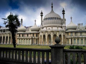
برايتون (بالانجليزية: Brighton؛ /ˈbraɪtən/) هي بلدة على الساحل الجنوبي لـبريطانيا العظمى. يبلغ عدد سكانها حوالي 125,000 نسمة.
الجغرافيا والطبوغرافيا
المناخ
Brighton has a temperate climate: its Köppen climate classification is Cfb. It is characterised by mild, calm weather with high levels of sunshine, sea breezes and a "healthy, bracing air" attributed to the low level of tree cover.[2] Average rainfall levels increase as the land rises: the 1958–1990 mean was 740 millimetres (29 in) on the seafront and about 1,000 millimetres (39 in) at the top of the South Downs above Brighton.[2] Storms caused serious damage in 1703, 1806, 1824, 1836, 1848, 1850, 1896, 1910 and 1987. Snow is rare, but particularly severe falls were recorded in 1881 and 1967.[2]
| Climate data for برايتون | |||||||||||||
|---|---|---|---|---|---|---|---|---|---|---|---|---|---|
| Month | Jan | Feb | Mar | Apr | May | Jun | Jul | Aug | Sep | Oct | Nov | Dec | Year |
| Mean daily maximum °C (°F) | 8 (46) |
8 (46) |
9 (49) |
12 (53) |
16 (60) |
18 (64) |
20 (68) |
21 (69) |
18 (65) |
15 (59) |
11 (52) |
9 (48) |
14 (57) |
| Mean daily minimum °C (°F) | 3 (38) |
3 (38) |
4 (40) |
6 (43) |
9 (48) |
12 (53) |
14 (58) |
14 (58) |
12 (54) |
9 (49) |
6 (43) |
4 (40) |
8 (47) |
| Average precipitation mm (inches) | 88 (3.5) |
60 (2.4) |
51 (2.0) |
58 (2.3) |
56 (2.2) |
50 (2.0) |
54 (2.1) |
62 (2.4) |
67 (2.6) |
105 (4.1) |
103 (4.1) |
97 (3.8) |
851 (33.5) |
| Source: Met Office | |||||||||||||
الحدود والمساحات
| Date from | Parish area[3] |
|---|---|
| ح. 11th century | 1,640 acres (660 ha) |
| 31 October 1873 | 2,445 acres (989 ha) |
| 1 October 1923 | 2,539 acres (1,027 ha) |
| 1 April 1928 | 12,503 acres (5,060 ha) |
| 1 April 1952 | 14,347 acres (5,806 ha) |
| 31 March 1972 | 15,041 acres (6,087 ha) |
| 1 April 1993 | 15,140 acres (6,130 ha) |
| 1 April 1997[note 1] | 21,632 acres (8,754 ha) |
المعالم
التعليم
Brighton & Hove City Council is responsible for 80 schools, of which 54 are in Brighton.[5]
The University of Sussex established in 1961 is a campus university between Stanmer Park and Falmer, four miles (6 km) from the city centre.
انظر أيضاً
- Royal Alexandra Hospital, Brighton – a children's hospital
- The Argus (Brighton) – newspaper
- Brighton in fiction
ملاحظات
الهامش
- ^ "The Mayor of Brighton and Hove" Archived 12 مايو 2019 at the Wayback Machine Brighton and Hove City Council. Retrieved 30 May 2019.
- ^ أ ب ت Carder 1990, §. 40.
- ^ Collis, pp. 34–35.
- ^ خطأ استشهاد: وسم
<ref>غير صحيح؛ لا نص تم توفيره للمراجع المسماةNEB35 - ^ "Brighton & Hove City Council – school contact information". Retrieved 20 August 2007.
وصلات خارجية
- برايتون at the Open Directory Project
- "Brighton & Hove City Council". Retrieved 20 August 2007.
- "Brighton from Space – Satellite image of Brighton courtesy of Google Maps". Retrieved 20 August 2007.
- "History of Brighton and the Royal Pavilion palace". Retrieved 20 August 2007.
- Pages using gadget WikiMiniAtlas
- Short description is different from Wikidata
- Coordinates on Wikidata
- Articles with OS grid coordinates
- Articles with hatnote templates targeting a nonexistent page
- برايتون
- Articles including recorded pronunciations (UK English)
- Brighton and Hove
- Former non-metropolitan districts of East Sussex
- Market towns in East Sussex
- Monarch's Way
- Places in East Sussex listed in the Domesday Book
- Populated coastal places in East Sussex
- Post towns in the BN postcode area
- Seaside resorts in England
- بلدات شرق سسكس
- مدن إنگلترة


