برايتون
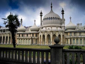
برايتون (بالانجليزية: Brighton؛ /ˈbraɪtən/ (![]() استمع)) هي بلدة على الساحل الجنوبي لـبريطانيا العظمى. يبلغ عدد سكانها حوالي 125,000 نسمة.
استمع)) هي بلدة على الساحل الجنوبي لـبريطانيا العظمى. يبلغ عدد سكانها حوالي 125,000 نسمة.
الجغرافيا والطبوغرافيا
المناخ
Brighton has a temperate climate: its Köppen climate classification is Cfb. It is characterised by mild, calm weather with high levels of sunshine, sea breezes and a "healthy, bracing air" attributed to the low level of tree cover.[2] Average rainfall levels increase as the land rises: the 1958–1990 mean was 740 ميليمتر (29 in) on the seafront and about 1،000 ميليمتر (39 in) at the top of the South Downs above Brighton.[2] Storms caused serious damage in 1703, 1806, 1824, 1836, 1848, 1850, 1896, 1910 and 1987. Snow is rare, but particularly severe falls were recorded in 1881 and 1967.[2]
| بيانات المناخ لـ برايتون | |||||||||||||
|---|---|---|---|---|---|---|---|---|---|---|---|---|---|
| الشهر | ينا | فب | مار | أبر | ماي | يون | يول | أغس | سبت | أكت | نوف | ديس | السنة |
| متوسط القصوى اليومية °س (°ف) | 8 (46) |
8 (46) |
9 (49) |
12 (53) |
16 (60) |
18 (64) |
20 (68) |
21 (69) |
18 (65) |
15 (59) |
11 (52) |
9 (48) |
14 (57) |
| متوسط الدنيا اليومية °س (°ف) | 3 (38) |
3 (38) |
4 (40) |
6 (43) |
9 (48) |
12 (53) |
14 (58) |
14 (58) |
12 (54) |
9 (49) |
6 (43) |
4 (40) |
8 (47) |
| متوسط تساقط الأمطار mm (inches) | 88 (3.5) |
60 (2.4) |
51 (2.0) |
58 (2.3) |
56 (2.2) |
50 (2.0) |
54 (2.1) |
62 (2.4) |
67 (2.6) |
105 (4.1) |
103 (4.1) |
97 (3.8) |
851 (33.5) |
| Source: Met Office | |||||||||||||
الحدود والمساحات
| Date from | Parish area[3] |
|---|---|
| ح. 11th century | 1،640 acre (660 ha) |
| 31 October 1873 | 2،445 acre (989 ha) |
| 1 October 1923 | 2،539 acre (1،027 ha) |
| 1 April 1928 | 12،503 acre (5،060 ha) |
| 1 April 1952 | 14،347 acre (5،806 ha) |
| 31 March 1972 | 15،041 acre (6،087 ha) |
| 1 April 1993 | 15،140 acre (6،130 ha) |
| 1 April 1997[note 1] | 21،632 acre (8،754 ha) |
المعالم
التعليم
Brighton & Hove City Council is responsible for 80 schools, of which 54 are in Brighton.[5]
The University of Sussex established in 1961 is a campus university between Stanmer Park and Falmer, four miles (6 km) from the city centre.
انظر أيضاً
- Royal Alexandra Hospital, Brighton – a children's hospital
- The Argus (Brighton) – newspaper
- Brighton in fiction
ملاحظات
الهامش
- ^ "The Mayor of Brighton and Hove" Archived 12 مايو 2019 at the Wayback Machine Brighton and Hove City Council. Retrieved 30 May 2019.
- ^ أ ب ت Carder 1990, §. 40.
- ^ Collis, pp. 34–35.
- ^ خطأ استشهاد: وسم
<ref>غير صحيح؛ لا نص تم توفيره للمراجع المسماةNEB35 - ^ "Brighton & Hove City Council – school contact information". Retrieved 20 August 2007.
وصلات خارجية
- برايتون at the Open Directory Project
- "Brighton & Hove City Council". Retrieved 20 August 2007.
- "Brighton from Space – Satellite image of Brighton courtesy of Google Maps". Retrieved 20 August 2007.
- "History of Brighton and the Royal Pavilion palace". Retrieved 20 August 2007.
- Pages using gadget WikiMiniAtlas
- Short description is different from Wikidata
- Coordinates on Wikidata
- Articles with OS grid coordinates
- Pages including recorded pronunciations
- Articles with hatnote templates targeting a nonexistent page
- برايتون
- Articles including recorded pronunciations (UK English)
- Brighton and Hove
- Former non-metropolitan districts of East Sussex
- Market towns in East Sussex
- Monarch's Way
- Places in East Sussex listed in the Domesday Book
- Populated coastal places in East Sussex
- Post towns in the BN postcode area
- Seaside resorts in England
- بلدات شرق سسكس
- مدن إنگلترة


