يوركشاير وهمبر
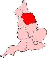 Yorkshire and the Humber في إنگلترة | |
| الجغرافيا | |
|---|---|
| الحالة | اقليم |
| المساحة الاجمالية | Ranked 5 15,420 كم² 5,953 ميل² |
| NUTS 1 | UKE |
| الديموغرافيا | |
| اجمالي الكثافة السكانية | الترتيب7 5,284,000 (2011) 343/كم² |
| القيمة المضافة للفرد | £16,880 (8) |
| الحكومة | |
| المقر الاداري | ويكفيلد [1] |
| القيادة | الحكومة المحلية في يوركشاير وهمبر |
| التنمية المحلية | يوركشاير فوروارد |
| البرلمان الأوروپي | يوركشاير وهمبر |
| الموقع الإلكتروني | |
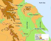
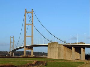
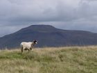
يوركشاير وهمبر Yorkshire and the Humber، هو أحد الأقاليم الإنگليزية التسعة الرسمية من المستوى الأول لأغراض إحصائية. ويغطي الاقليم معظم مقاطعة يوركشاير التاريخية، بالإضافة إلى جزء من شمال لينكولنشاير، التي كانت من عام 1974 حتى 1996، جزء من مقاطعة شاير في همبرسايد. في 2011 وصل عدد سكان الاقليم إلى 5,284,000 نسمة.[2] أعلنت الحكومة البريطانية عزمها على إلغاء المكاتب الحكومية (عن الأقاليم) في موعد أقصاه 31 مارس 2011.
. . . . . . . . . . . . . . . . . . . . . . . . . . . . . . . . . . . . . . . . . . . . . . . . . . . . . . . . . . . . . . . . . . . . . . . . . . . . . . . . . . . . . . . . . . . . . . . . . . . . . . . . . . . . . . . . . . . . . . . . . . . . . . . . . . . . . . . . . . . . . . . . . . . . . . . . . . . . . . . . . . . . . . . .
الجغرافيا
 |
|---|
انظر المناطق الطبوغرافية في يوركشاير وجيولوجيا يوركشاير
الجيولوجيا
الأنهار
المناخ
بيانات المناخ في مدن الاقليم:
| Climate data for هول | |||||||||||||
|---|---|---|---|---|---|---|---|---|---|---|---|---|---|
| Month | Jan | Feb | Mar | Apr | May | Jun | Jul | Aug | Sep | Oct | Nov | Dec | Year |
| Mean daily maximum °C (°F) | 6.9 (44.4) |
7.3 (45.1) |
9.5 (49.1) |
11.4 (52.5) |
14.6 (58.3) |
17.7 (63.9) |
20.1 (68.2) |
20.2 (68.4) |
17.7 (63.9) |
14.0 (57.2) |
9.9 (49.8) |
7.8 (46.0) |
13.1 (55.6) |
| Mean daily minimum °C (°F) | 1.6 (34.9) |
1.7 (35.1) |
3.1 (37.6) |
4.6 (40.3) |
6.9 (44.4) |
9.7 (49.5) |
12.2 (54.0) |
12.2 (54.0) |
10.4 (50.7) |
7.4 (45.3) |
4.1 (39.4) |
2.4 (36.3) |
6.4 (43.5) |
| Average precipitation mm (inches) | 50.7 (2.00) |
38.3 (1.51) |
45.6 (1.80) |
42.4 (1.67) |
43.5 (1.71) |
50 (2.0) |
38.4 (1.51) |
48.7 (1.92) |
52.1 (2.05) |
46.5 (1.83) |
57.2 (2.25) |
52.0 (2.05) |
565.4 (22.26) |
| [بحاجة لمصدر] | |||||||||||||
| Climate data for Leeds | |||||||||||||
|---|---|---|---|---|---|---|---|---|---|---|---|---|---|
| Month | Jan | Feb | Mar | Apr | May | Jun | Jul | Aug | Sep | Oct | Nov | Dec | Year |
| Mean daily maximum °C (°F) | 5.8 (42.4) |
5.9 (42.6) |
8.7 (47.7) |
11.3 (52.3) |
15.0 (59.0) |
18.2 (64.8) |
19.9 (67.8) |
19.9 (67.8) |
17.3 (63.1) |
13.4 (56.1) |
8.8 (47.8) |
6.7 (44.1) |
12.6 (54.6) |
| Mean daily minimum °C (°F) | 0.3 (32.5) |
0.2 (32.4) |
1.6 (34.9) |
3.1 (37.6) |
5.5 (41.9) |
8.5 (47.3) |
10.4 (50.7) |
10.5 (50.9) |
8.7 (47.7) |
6.3 (43.3) |
2.9 (37.2) |
1.2 (34.2) |
4.9 (40.9) |
| Average rainfall mm (inches) | 61 (2.4) |
45 (1.8) |
52 (2.0) |
48 (1.9) |
54 (2.1) |
54 (2.1) |
51 (2.0) |
65 (2.6) |
57 (2.2) |
55 (2.2) |
57 (2.2) |
61 (2.4) |
660 (25.9) |
| [بحاجة لمصدر] | |||||||||||||
| Climate data for شفيلد | |||||||||||||
|---|---|---|---|---|---|---|---|---|---|---|---|---|---|
| Month | Jan | Feb | Mar | Apr | May | Jun | Jul | Aug | Sep | Oct | Nov | Dec | Year |
| Mean daily maximum °C (°F) | 6.4 (43.5) |
6.7 (44.1) |
9.3 (48.7) |
11.8 (53.2) |
15.7 (60.3) |
18.3 (64.9) |
20.8 (69.4) |
20.6 (69.1) |
17.3 (63.1) |
13.3 (55.9) |
9.2 (48.6) |
7.2 (45.0) |
13.1 (55.6) |
| Mean daily minimum °C (°F) | 1.6 (34.9) |
1.6 (34.9) |
3.1 (37.6) |
4.4 (39.9) |
7.0 (44.6) |
10.0 (50.0) |
12.4 (54.3) |
12.1 (53.8) |
10.0 (50.0) |
7.2 (45.0) |
4.2 (39.6) |
2.6 (36.7) |
6.4 (43.5) |
| Average precipitation mm (inches) | 86.5 (3.41) |
63.4 (2.50) |
67.9 (2.67) |
62.5 (2.46) |
55.5 (2.19) |
66.7 (2.63) |
51.0 (2.01) |
63.5 (2.50) |
64.3 (2.53) |
73.9 (2.91) |
77.7 (3.06) |
91.9 (3.62) |
824.7 (32.47) |
| [بحاجة لمصدر] | |||||||||||||
| Climate data for يورك | |||||||||||||
|---|---|---|---|---|---|---|---|---|---|---|---|---|---|
| Month | Jan | Feb | Mar | Apr | May | Jun | Jul | Aug | Sep | Oct | Nov | Dec | Year |
| Mean daily maximum °C (°F) | 6 (43) |
7 (45) |
10 (50) |
13 (55) |
16 (61) |
19 (66) |
21 (70) |
21 (70) |
18 (64) |
14 (57) |
10 (50) |
7 (45) |
14 (56) |
| Mean daily minimum °C (°F) | 1 (34) |
1 (34) |
2 (36) |
4 (39) |
7 (45) |
10 (50) |
12 (54) |
12 (54) |
10 (50) |
7 (45) |
4 (39) |
2 (36) |
6 (43) |
| Average precipitation mm (inches) | 59 (2.3) |
46 (1.8) |
37 (1.5) |
41 (1.6) |
50 (2.0) |
50 (2.0) |
62 (2.4) |
68 (2.7) |
55 (2.2) |
56 (2.2) |
65 (2.6) |
50 (2.0) |
639 (25.3) |
| Source: BBC Weather[6] | |||||||||||||
. . . . . . . . . . . . . . . . . . . . . . . . . . . . . . . . . . . . . . . . . . . . . . . . . . . . . . . . . . . . . . . . . . . . . . . . . . . . . . . . . . . . . . . . . . . . . . . . . . . . . . . . . . . . . . . . . . . . . . . . . . . . . . . . . . . . . . . . . . . . . . . . . . . . . . . . . . . . . . . . . . . . . . . .
المدن

الحكومة المحلية
يضم الاقليم رسمياً التقسيمات التالية:[7]
| خريطة | مقاطعة احتفالية | المقاطعة/ unitary | Districts |
|---|---|---|---|
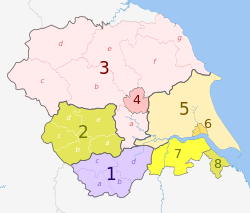 |
1. جنوب يوركشاير * | a) شفيلد، b) روترهام، c) بارنسلي، d) دونكاستر | |
| 2. غرب يوركشاير * | a) ويكفيلد، b) كيرلس، c) كالدردال، d) برادفورد، e) ليدز | ||
| شمال يوركشاير (جزء فقط) |
3. شمال يوركشاير † | a) سلبي، b) هاروگيت,، c) كراڤن، d) ريتشموندشاير، e) هامبلتون، f) ريدال، g) سكاربوروف | |
| 4. يورك U.A. | |||
| East Riding of Yorkshire | 5. East Riding of Yorkshire U.A. | ||
| 6. كينگستون أپون هول U.A. | |||
| ليكولنشاير (جزء فقط) |
7. شمال لينكولنشاير U.A. | ||
| 8. شمال شرق ليكولنشاير U.A. | |||
المفتاح: †مقاطعة شاير | *مقاطعة كبرى
التاريخ
التاريخ الصناعي
الإرث العلمي
الثقافة
المجلس المحلي
البرلمان الأوروپي
نتائج انتخابات 2009
| الانتخابات الأوروپية 2009: يوركشاير وهمبر[8][9] | |||||
|---|---|---|---|---|---|
| القائمة | المرشحون | الأصوات | % | ±% | |
| Conservative | Edward McMillan-Scott, Timothy Kirkhope Fleur Butler, Matthew Bean, Nick Burrows, Glynis Frew |
299,802 (149,901) |
24.5 | -0.2 | |
| Labour | Linda McAvan Richard Corbett, Emma Hoddinott, David Bowe, Melanie Onn, Mahroof Hussain |
230,009 | 18.8 | -7.5 | |
| UKIP | Godfrey Bloom Jonathan Arnott, Jason Smith, Toby Horton, David Daniel, Lynette Afshar |
213,750 | 17.4 | +2.9 | |
| Liberal Democrats | Diana Wallis Stewart Arnold, Rebecca Taylor, James Monaghan, Nader Fekri, Neil Poole |
161,552 | 13.2 | -2.4 | |
| BNP | Andrew Brons Nick Cass, Chris Beverley, Marlene Guest, Paul Harris, Trevor Brown |
120,139 | 9.8 | +1.8 | |
| Green | Martin Hemingway, Shan Oakes, Leslie Rowe, Rick Rolt, Kevin Warnes, Lesley Hedges | 104,456 | 8.5 | +2.8 | |
| English Democrat | Michael Cassidy, Joanne Robinson, Peter Davies, David Wildgoose, Paul McEnhill, Geoffery Crossman | 31,287 | 2.6 | +1.0 | |
| Socialist Labour | William Capstick, Linda Sheriden, Stephen Yoxall, Holly Jo Yoxall, Terence Robinson, Christopher Butler | 19,380 | 1.6 | N/A | |
| Christian | Sid Cordle, Andrew McClintock, Angela MacDonald, John O'Brien, Samantha Cauldwell, Rebecca Jones | 16,742 | 1.4 | N/A | |
| NO2EU | Keith Gibson, Celia Foote, Jackie Grunsell, Peter Marsh, Mike Davies, Juliet Marie Boddington | 15,614 | 1.3 | N/A | |
| Jury Team (UK) | Barbara Hibbert, Anthony Hooper, Ben Saxton | 7,181 | 0.6 | N/A | |
| Libertas | Antony Devoy, Edward Devoy, Stephen Clark, Diana MacLeod, Trevor Bending, Kathleen Harris | 6,268 | 0.5 | N/A | |
| الإقبال على الانتخابات | 1,226,180 | 32.3 | -10.3 | ||
. . . . . . . . . . . . . . . . . . . . . . . . . . . . . . . . . . . . . . . . . . . . . . . . . . . . . . . . . . . . . . . . . . . . . . . . . . . . . . . . . . . . . . . . . . . . . . . . . . . . . . . . . . . . . . . . . . . . . . . . . . . . . . . . . . . . . . . . . . . . . . . . . . . . . . . . . . . . . . . . . . . . . . . .
الديموغرافيا
السكان، الكثافة السكانية، والمدن
| الاقليم/المقاطعة | السكان | الكثافة السكانية | أكبر مدينة/بلدة | أكبر منطقة حضرية |
|---|---|---|---|---|
| يوركشاير وهمبر | 5,177,200 | 328/كم² | ليدز (761,100) | منطقة غرب يوركشاير الكبرى (1,499,465) |
| غرب يوركشاير | 2,118,600 | 1,004/كم² | ليدز (761,100) | منطقة غرب يوركشاير الكبرى (1,499,465) |
| جنوب يوركشاير | 1,292,900 | 833/كم² | شفيلد (530,300) | منطقة شفيلد الكبرى (640,720) |
| East Riding of Yorkshire | 587,100 | 137/كم² | Kingston upon Hull (257,000) | Kingston upon Hull Urban Area (301,416) |
| شمال يوركشاير | 1,061,300 | 123/كم² | مدينة يورك (193,300) | منطقة يورك الكبرى (137,505) |
| شمال لينكولنشاير | 159,000 | 188/كم² | Scunthorpe (72,660) | Scunthorpe (72,660) |
| شمال شرق لينكولنشاير | 158,900 | 828/كم² | گريمسبي (87,574) | گريمسبي/كليثورپس (138,842) |
حمل المراهقين
الحرمان الاجتماعي
الانتخابات
الأقاليم الاحصائية في الاتحاد الأوروپي
| من المستوى 1 | الرمز | من المستوى 2 | الرمز | من المستوى 3 | الرمز |
|---|---|---|---|---|---|
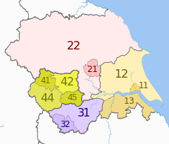
| يوركشاير وهمبر | UKE | East Riding and North Lincolnshire | UKE1 | Kingston upon Hull | UKE11 |
|
East Riding of Yorkshire | UKE12 | |||
| شمال وشمال شرق لينكولنشاير | UKE13 | ||||
| شمال يوركشاير | UKE2 | يورك | UKE21 | ||
| شمال يوركشاير CC | UKE22 | ||||
| جنوب يوركشاير | UKE3 | بارنسلي، دونكاستر وروثرهام | UKE31 | ||
| شفيلد | UKE32 | ||||
| غرب يوركشاير | UKE4 | برادفورد | UKE41 | ||
| ليدز | UKE42 | ||||
| Calderdale and كيركليس | UKE44 | ||||
| ويكفيلد | UKE45 | ||||
سياسة النقل
الطرق
السكك الحديدية


النقل الجماعي
النقل الجوي

النقل المائي

الاقتصاد
الشرق والشمال
الغرب والجنوب
الرياضة
التعليم
 مقالة مفصلة: قائمة جامعات يوركشاير وهمبر

الاعلام المحلي
المصادر
- ^ "Government Offices | National | Contact Us". Local Government Yorkshire and Humber. Retrieved 2011-04-23.
- ^ "2011 Census - Population and Household Estimates for England and Wales, March 2011" (PDF). Office of National Statistics. 2012. Retrieved 2012-07-16.
- ^ "Cleethorpes 1971–2000 averages". Met Office. Retrieved 7 June 2008.
- ^ "Leeds average weather data". www.worldtravels.com. Retrieved 2010-11-14.
- ^ "Sheffield 1971–2000 averages". Met Office. Retrieved 17 July 2010.
- ^ "Average Conditions - York, United Kingdom". BBC Weather. BBC. Retrieved 8 March 2010.
- ^ "Local Authorities". Government Office for Yorkshire and the Humber. 2008. Retrieved 2008-05-06.
{{cite web}}: Unknown parameter|month=ignored (help) - ^ "European Parliamentary Election Thursday 4th June 2009 Yorkshire and The Humber Region Statement of Parties Nominated" (PDF). Retrieved 2010-01-09.
- ^ "European Election 2009: Yorkshire and the Humber". BBC News Online. BBC. 2009-06-07. Retrieved 2010-01-09.
- ^ Office for National Statistics. (2008). "Fact Files: Yorkshire and The Humber > Yorkshire and The Humber". Government Office for Yorkshire and the Humber. Retrieved 2008-05-06.
{{cite web}}: Unknown parameter|month=ignored (help)
وصلات خارجية
- CS1 errors: unsupported parameter
- Articles with unsourced statements from February 2011
- Articles with unsourced statements from October 2010
- Articles with unsourced statements from August 2010
- Articles with hatnote templates targeting a nonexistent page
- مقالات ذات عبارات بحاجة لمصادر
- أقاليم التصنيف الأول في إنگلترة
- أقاليم التصنيف الأول في الاتحاد الأوروپي
- يوركشاير
- يوركشاير وهمبر
