موربيان
Morbihan
Mor-Bihan (بريتونية) | |
|---|---|
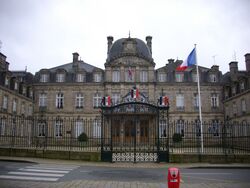
 Prefecture building of the Morbihan department, in Vannes | |
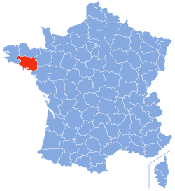
 Location of Morbihan in France | |
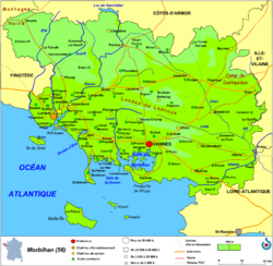
 Map of Morbihan | |
| الإحداثيات: 47°50′N 02°50′W / 47.833°N 2.833°W | |
| Country | France |
| Region | Brittany |
| Prefecture | Vannes |
| Subprefectures | Lorient Pontivy |
| الحكومة | |
| • President of the Departmental Council | David Lappartient[1] |
| المساحة | |
| • الإجمالي | 6٬823 كم² (2٬634 ميل²) |
| التعداد (يناير 2019) | |
| • الإجمالي | 759٬684 |
| • الترتيب | 31st |
| • الكثافة | 110/km2 (290/sq mi) |
| منطقة التوقيت | UTC+1 (CET) |
| • الصيف (التوقيت الصيفي) | UTC+2 (CEST) |
| ISO 3166 code | FR-56 |
| Department number | 56 |
| Arrondissements | 3 |
| Cantons | 21 |
| Communes | 249 |
| ^1 French Land Register data, which exclude estuaries, and lakes, ponds, and glaciers larger than 1 km2 | |
موربيان (بالفرنسية:Morbihan) هو إقليم فرنسي، يقع في منطقة بريتاني، وتقع في شمال غرب فرنسا. سمي باسم موربيهان نسبة لبحيرة موربيهان (بحيرة صغيرة في بريتون). situated in the northwest of France. It is named after the Morbihan (small sea in Breton), the enclosed sea that is the principal feature of the coastline. It had a population of 759,684 in 2019.[2] It is noted for its Carnac stones, which predate and are more extensive than the Stonehenge monument in Wiltshire, England.
Three major military educational facilities are located in Guer, including École Spéciale Militaire de Saint-Cyr, the national military academy for officers.
التاريخ
إقليم موربيا هو واحد من الأقاليم الـ 83 التي تتشكل منها فرنسا، أنشئت خلال الثورة الفرنسية يوم 4 مارس 1790، أنشئت من جزء من منطقة دوقية بريتاني.
In 1945 cadets from École Spéciale Militaire de Saint-Cyr, France's foremost military academy for officers, were relocated to Camp Coëtquidan (Camp de Coëtquidan) in Guer. This has been developed to include also the École militaire interarmes (inter-services military school), for non-commissioned officers; and École Militaire du Corps Technique et Administratif (military school of the technical and administrative corps).
الجغرافيا
إقليم موربيا هو جزء من المنطقة الحالية من بريتاني وتحيط به الأقاليم التالية : فينستر (بالفرنسية:Finistère)، كوتس دي أرمور (بالفرنسية:Côtes-d'Armor)، ايل فيلان (بالفرنسية:Ille-et-Vilaine)، ولوار اتلانتيك (بالفرنسية:Loire-Atlantique)، والمحيط الأطلسي في جنوب غرب البلاد.
يملك إقليم موربيا خليج موربيهان والذي يملك العديد من الجزر : إذ يبلغ عددها 365 وفقا للاساطير، ولكن في الواقع فهي ما بين 30 و 40 جزيرة، وهناك أيضا العديد من الجزر الصغيرة التي يمكن البناء عليه.
Principal towns
The most populous commune is Lorient; the prefecture Vannes is the second-most populous. As of 2019, there are 6 communes with more than 15,000 inhabitants:[2]
| Commune | Population (2019) |
|---|---|
| Lorient | 57,246 |
| Vannes | 53,719 |
| Lanester | 23,124 |
| Ploemeur | 17,778 |
| Hennebont | 16,062 |
| Pontivy | 15,064 |
الجزر
السكان
|
| |||||||||||||||||||||||||||||||||||||||||||||||||||||||||||||||||||||||||||
| Sources:[3][4] | ||||||||||||||||||||||||||||||||||||||||||||||||||||||||||||||||||||||||||||
الثقافة
تعتبر لغة بريتون مسألة هامة في الإقليم، مع العديد من العاوى في المحاكم إلى السماح بالتعليم بلغتين.
الفن
الرسام ريمون وينتز (1884-1956) الذي صور مواقع مختلف في أنحاء خليج موربيهان.
السياسة
As of 2014, the préfet of Morbihan is Jean-François Savy, previously head of the Prefectures of Ardennes and of Hautes-Alpes.[5] The president of the Departmental Council is David Lappartient, elected in July 2021.
Current National Assembly Representatives
السياحة
- The Carnac stones, megalithic alignments of Carnac, are situated in Morbihan.
- Tourism office of Auray
The Gulf of Morbihan is a popular sailing destination
The bagad of Lann-Bihoué
انظر أيضاً
- Cantons of the Morbihan department
- Communes of the Morbihan department
- Arrondissements of the Morbihan department
- La Baule - Guérande Peninsula
المصادر
وصلات خارجية
- (بالفرنسية) Prefecture website
- (بالفرنسية) General Council website
- (إنگليزية) Morbihan at the Open Directory Project
- (بالفرنسية) Cultural Heritage
- (بالفرنسية) Tourism website
- (إنگليزية) Hiking in Morbihan
- ^ "Répertoire national des élus: les conseillers départementaux". data.gouv.fr, Plateforme ouverte des données publiques françaises (in الفرنسية). 4 May 2022.
- ^ أ ب Populations légales 2019: 56 Morbihan, INSEE
- ^ "Historique du Morbihan". Le SPLAF.
- ^ "Évolution et structure de la population en 2016". INSEE.
- ^ "Le préfet du Morbihan". Morbihan Prefecture website.
- ^ Assemblée Nationale. "Assemblée nationale ~ Les députés, le vote de la loi, le Parlement français". Assemblee-nationale.fr. Retrieved 2019-09-04.


