فورت لي، نيوجرزي
فورت لي، نيوجرزي Fort Lee, New Jersey | |
|---|---|
| Borough of Fort Lee | |
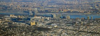 Fort Lee, New Jersey in the foreground, connected by the George Washington Bridge to Upper Manhattan, New York City across the Hudson River, in the background. | |
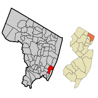 خريطة موضح عليها موقع فورت لي في مقاطعة برگن. | |
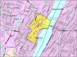 خريطة مكتب تعداد فورت لي، نيوجرزي | |
| الإحداثيات: 40°51′02″N 73°58′16″W / 40.85064°N 73.971007°W | |
| البلد | |
| الولاية | |
| المقاطعة | برگن |
| دُمجت | 29 مارس 1904 |
| السمِيْ | الجنرال تشارلز لي |
| الحكومة | |
| • النوع | Borough |
| • العمدة | مارك سوكوليتش (د، ستنتهي ولايته في 31 ديسمبر 2015)[3] |
| • المدير | پگي إ. توماس[4] |
| • Clerk | Neil Grant[5] |
| المساحة | |
| • الإجمالي | 7٫478 كم² (2٫888 ميل²) |
| • البر | 6٫581 كم² (2٫541 ميل²) |
| • الماء | 0٫898 كم² (0٫347 ميل²) 12.00% |
| ترتيب المساحة | 342 على 566 في الولاية 29على 70 في المقاطعة[2] |
| المنسوب | 88 m (289 ft) |
| التعداد | |
| • الإجمالي | 35٬345 |
| • Estimate (2012[10]) | 35٬732 |
| • الترتيب | 67 من 566 في الولاية 3 من 70 في لامقاطعة[11] |
| • الكثافة | 5٬371٫0/km2 (13٬910٫9/sq mi) |
| • ترتيب الكثافة | 16 من 566 في الولاية 5 من 70 في المقاطعة[11] |
| منطقة التوقيت | UTC-5 (Eastern (EST)) |
| • الصيف (التوقيت الصيفي) | UTC-4 (Eastern (EDT)) |
| ZIP code | |
| مفتاح الهاتف | 201[14] |
| FIPS code | 3400324420[15][2][16] |
| GNIS feature ID | 0885223[17][2] |
| الموقع الإلكتروني | www |
فورت لي Fort Lee، هي borough في مقاطعة برگن، نيوجرزي، الولايات المتحدة، في منطقة مدينة نيويورك الكبرى. حسب تعداد 2010، كان عدد سكانها 35.345 نسمة،[8][18] مما يعكس نسبة إنخفاض مقدارها 116 (−0.3%) عن 35,461 نسمة حسب تعداد 2000، والذي تزايد عن تعداد 1999 بمقدار 3,464 نسمة (+10.8%).[19]
الجغرافيا
التاريخ

Residential high-rises, several over 100 meters tall, are a prominent feature of the borough.
أول صناعة سينمائية في الولايات المتحدة
مهد الإعلانات الغير مباشرة
فضيحة فتح حارات جسر جورج واشنطن
الديموغرافيا

Fort Lee Koreatown (포트 리 코리아타운)[20] is centered at the intersection of Main Street and Route 67 (Lemoine Avenue). Click on image for greater Hangul resolution.
| التعداد التاريخي | |||
|---|---|---|---|
| التعداد | Pop. | %± | |
| 1900 | 2٬612 | — | |
| 1910 | 4٬472 | 71٫2% | |
| 1920 | 5٬761 | 28٫8% | |
| 1930 | 8٬759 | 52�0% | |
| 1940 | 9٬468 | 8٫1% | |
| 1950 | 11٬648 | 23�0% | |
| 1960 | 21٬815 | 87٫3% | |
| 1970 | 30٬631 | 40٫4% | |
| 1980 | 32٬449 | 5٫9% | |
| 1990 | 31٬997 | −1٫4% | |
| 2000 | 35٬461 | 10٫8% | |
| 2010 | 35٬345 | −0٫3% | |
| 2012 (تق.) | 35٬732 | [10] | 1٫1% |
| Population sources: 1910–1920[21] 1910[22] 1910–1930[23] 1900–2010[24] 2000[25][26] 2010[8][9][18] | |||
تعداد 2010
تعداد 2000
الحكومة
الحكومة المحلية
التمثيل الفدرالي، على مستوى الولاية والمقاطعة
السياسة
خدمات الطوارئ والسلامة العامة
الشرطة
خدمة الطوارئ الطبية
ادارة الحريق
التعليم
الاقتصاد
النقل
الطرق والطرق السريعة
النقل العام
المناخ
في الإعلام
مشاهير فورت لي
انظر أيضاً
المراجع
- Clayton, W. Woodford; and Nelson, William. History of Bergen and Passaic Counties, New Jersey, with Biographical Sketches of Many of its Pioneers and Prominent Men. Philadelphia: Everts and Peck, 1882.
- Harvey, Cornelius Burnham (ed.), Genealogical History of Hudson and Bergen Counties, New Jersey. New York: New Jersey Genealogical Publishing Co., 1900.
- Van Valen, James M. History of Bergen County, New Jersey. New York: New Jersey Publishing and Engraving Co., 1900.
- Westervelt, Frances A. (Frances Augusta), 1858–1942, History of Bergen County, New Jersey, 1630–1923, Lewis Historical Publishing Company, 1923.
المصادر
- ^ "US Gazetteer files: 2010, 2000, and 1990". United States Census Bureau. 2011-02-12. Retrieved 2011-04-23.
- ^ أ ب ت ث ج Gazetteer of New Jersey Places, United States Census Bureau. Accessed June 14, 2013.
- ^ 2013 New Jersey Mayors Directory, New Jersey Department of Community Affairs. Accessed May 12, 2013.
- ^ Borough Administrator's Office, Borough of Fort Lee. Accessed June 30, 2012.
- ^ Borough Clerk's Office, Borough of Fort Lee. Accessed June 30, 2012.
- ^ خطأ استشهاد: وسم
<ref>غير صحيح؛ لا نص تم توفيره للمراجع المسماةDataBook - ^ U.S. Geological Survey Geographic Names Information System: Borough of Fort Lee, Geographic Names Information System. Accessed March 5, 2013.
- ^ أ ب ت DP-1 – Profile of General Population and Housing Characteristics: 2010 for Fort Lee borough, Bergen County, New Jersey, United States Census Bureau. Accessed February 5, 2012.
- ^ أ ب Table DP-1. Profile of General Demographic Characteristics: 2010 for Fort Lee borough, New Jersey Department of Labor and Workforce Development. Accessed February 5, 2012.
- ^ أ ب PEPANNRES – Annual Estimates of the Resident Population: April 1, 2010 to July 1, 2012 – 2012 Population Estimates for New Jersey municipalities, United States Census Bureau. Accessed July 7, 2013.
- ^ أ ب GCT-PH1 Population, Housing Units, Area, and Density: 2010 – State – County Subdivision from the 2010 Census Summary File 1 for New Jersey, United States Census Bureau. Accessed October 9, 2012.
- ^ Look Up a ZIP Code for Fort Lee, NJ, United States Postal Service. Accessed September 26, 2011.
- ^ Zip Codes, State of نيوجرزي. Accessed August 28, 2013.
- ^ Area Code Lookup – NPA NXX for Fort Lee, NJ, Area-Codes.com. Accessed October 13, 2013.
- ^ "American FactFinder". United States Census Bureau. Retrieved 2008-01-31.
- ^ A Cure for the Common Codes: New Jersey, Missouri Census Data Center. Accessed October 9, 2012.
- ^ "US Board on Geographic Names". United States Geological Survey. 2007-10-25. Retrieved 2008-01-31.
- ^ أ ب خطأ استشهاد: وسم
<ref>غير صحيح؛ لا نص تم توفيره للمراجع المسماةDistricts2011 - ^ Table 7. Population for the Counties and Municipalities in New Jersey: 1990, 2000 and 2010, New Jersey Department of Labor and Workforce Development, February 2011. Accessed June 30, 2012.
- ^ Asian Americans: Contemporary Trends and Issues Second Edition, Edited by Pyong Gap Min. Pine Forge Press – An Imprint of Sage Publications, Inc. 2006. Retrieved March 28, 2012.
- ^ Compendium of censuses 1726–1905: together with the tabulated returns of 1905, New Jersey Department of State, 1906. Accessed October 13, 2013.
- ^ Thirteenth Census of the United States, 1910: Population by Counties and Minor Civil Divisions, 1910, 1900, 1890, United States Census Bureau, p. 335. Accessed October 13, 2013.
- ^ Fifteenth Census of the United States : 1930 – Population Volume I, United States Census Bureau, p. 714. Accessed February 14, 2012.
- ^ Historical Population Trends in Bergen County (1900–2010), Bergen County, New Jersey Department of Planning & Economic Development, 2011. Accessed October 13, 2013. Data for 1900, prior to the borough's formation, was extrapolated by analysts from Bergen County.
- ^ خطأ استشهاد: وسم
<ref>غير صحيح؛ لا نص تم توفيره للمراجع المسماةCensus2000 - ^ خطأ استشهاد: وسم
<ref>غير صحيح؛ لا نص تم توفيره للمراجع المسماةCensus2000SF1 - ^ "Port Authority of New York and New Jersey – George Washington Bridge". The Port Authority of New York and New Jersey. Retrieved September 13, 2013.
- ^ Bod Woodruff, Lana Zak, and Stephanie Wash (November 20, 2012). "GW Bridge Painters: Dangerous Job on Top of the World's Busiest Bridge". ABC News. Retrieved September 13, 2013.
{{cite web}}: CS1 maint: multiple names: authors list (link)
وصلات خارجية
- Borough of Fort Lee web site
- Fort Lee Police Department
- Fort Lee Volunteer Fire Department
- Fort Lee Volunteer Ambulance Corps
- Fort Lee School District
- Fort Lee School District's 2012–13 School Report Card from the New Jersey Department of Education
- Data for the Fort Lee School District, National Center for Education Statistics
- Fort Lee Online community web site
- Fort Lee Film Commission web site
- An enlarged view of road jurisdiction at the Fort Lee approaches to the George Washington Bridge
الكلمات الدالة:
تصنيفات:
- Short description is different from Wikidata
- Pages using gadget WikiMiniAtlas
- Articles with hatnote templates targeting a nonexistent page
- Pages using US Census population needing update
- فورت لي، نيوجرزي
- تأسيسات 1904 في نيوجرزي
- Borough form of New Jersey government
- Boroughs in Bergen County, New Jersey
- حصون في نيوجرزي
- أماكن مأهولة تأسست في 1904
- أماكن مأهولة في الولايات المتحدة ذات أغلبية آسيوية
- أماكن مأهولة على نهر هدسون

