فلوريانوپوليس
Florianópolis | |
|---|---|
| Município de Florianópolis Municipality of Florianópolis | |
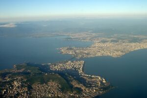
من أعلى لأسفل ومن اليسار لليمين: پانوراما المنطقة الوسطة من مورو دا كروز؛ Hercílio Luz Bridge at night; Florianópolis Cathedral; Beira Mar Avenue; Public Market; Joaquina Beach; Fortress of São José da Ponta Grossa. | |
| الكنية: فلوريپا، الجزيرة الساحرة | |
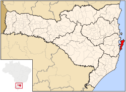 | |
| الإحداثيات: 27°36′44″S 48°29′7″W / 27.61222°S 48.48528°W | |
| Country | |
| الإقليم | الجنوبي |
| الولاية | |
| تأسست | 23 مارس 1673 (348 years) |
| السمِيْ | Floriano Peixoto |
| الحكومة | |
| • العمدة | Gean Loureiro (ديمقراط) |
| المساحة | |
| • بلدية | 675٫409 كم² (260٫777 ميل²) |
| المنسوب | 3 m (9 ft) |
| التعداد (2020 [1]) | |
| • بلدية | 508٬826 |
| • الكثافة | 750/km2 (2٬000/sq mi) |
| • Urban | 358٬180 |
| • العمرانية | 1٬111٬702 |
| صفة المواطن | Florianopolitano Manezinho (colloquial) |
| منطقة التوقيت | UTC-3 (UTC-3) |
| Postal Code | 88000-000 to 88099-999 |
| مفتاح الهاتف | (+55) 48 |
| الموقع الإلكتروني | Florianópolis, SC |
فلوريانوپوليس (Florianópolis ؛ النطق في البرتغالية: [floɾi.aˈnɔpolis]) هي عاصمة وثاني أكبر مدن ولاية سانتا كاتارينا، في الاقليم الجنوبي، في البرازيل. المدينة تضم جزيرة سانتا كاتارينا والجزر الصغيرة المحيطة بها، وكذلك جزء من البر الرئيسي. وقد بلغ عدد سكانها 508,826 نسمة، في تقدير التعداد لسنة 2020 من IBGE (المعهد البرازيلي للجغرافيا والإحصاء)، ثاني أكبر المدن تعداداً في الولاية (بعد جوينڤيل)، ورقم 47 في البرازيل. المنطقة العمرانية يُقدّر عدد سكانها بنحو 1,111,702 نسمة، رقم 21 بين أكبر المناطق في البلد. وتُعرف المدينة بامتلاكها ثالث أعلى مؤشر التنمية البشرية بين كل المدن البرازيلية (0.847).[2][3]
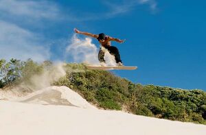
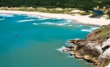
اقتصاد فلوريانوپوليس يرتكز بقوة على تكنولوجيا المعلومات والسياحة والخدمات.[4] ولدى المدينة 60 شاطئ وهي مركز surfing activity. Lagoa da Conceição is the most famous area for tourism, recreation, nature and radical sports. The New York Times reported that "Florianopolis is the Party Destination of the Year in 2009."[5] Newsweek placed Florianópolis in the "Ten most dynamic cities of the world" list in 2006.[6] Veja, a Brazilian publication, named the city as "the best place to live in Brazil."[7] As a result of this exposure, Florianópolis is growing as a second home destination for many Paulistas, Argentines, North Americans, and Europeans.
كما يشيع معرفة فلوريانوپوليس بالكنى Floripa and Ilha da Magia (Magic Island).[8][9] Most of the population lives on the mainland and on the island's central and northern parts. The southern half is less inhabited. Many small commercial fishermen populate the island. The fishing boats, the lacemakers, the folklore, the cuisine and the colonial architecture contribute to the growing tourism and attracts resources that compensate for the lack of any large industry. تنغمس القرى في التقاليد والتاريخ، such as Santo Antônio de Lisboa and Ribeirão da Ilha still resist the advances of modernity.[10]
يخدم مطار هرسيليو لوز الدولي المدينة. Florianópolis is home to the Universidade Federal de Santa Catarina (Federal University of Santa Catarina). There are also the Santa Catarina Federal Institute of Education, Science and Technology (Instituto Federal de Santa Catarina), and two campuses of the جامعة ولاية سانتا كاتارينا (State University of Santa Catarina), among other institutions of higher and professional education.
. . . . . . . . . . . . . . . . . . . . . . . . . . . . . . . . . . . . . . . . . . . . . . . . . . . . . . . . . . . . . . . . . . . . . . . . . . . . . . . . . . . . . . . . . . . . . . . . . . . . . . . . . . . . . . . . . . . . . . . . . . . . . . . . . . . . . . . . . . . . . . . . . . . . . . . . . . . . . . . . . . . . . . . .
أصل الاسم
الاسم فلوريانوپوليس هو تخليد لذكرى المارشال Floriano Peixoto، ثاني رئيس (1891–1894) لجمهورية الولايات المتحدة البرازيلية ومن الكلمة اليونانية polis، وتعني "مدينة". حتى 1893، the city was called Nossa Senhora do Desterro (Our Lady of Banishment) أو ببساطة "Desterro".
الجغرافيا
النبيت
Florianópolis has a native Atlantic Forest-type vegetation. This vegetation has an extremely diverse and unique mix of vegetation and forest types. The main ecoregion is the coastal Atlantic forest, the narrow strip of about 50–100 kilometers (31–62 miles) along the coast which covers about 20 percent of the region. This forest extends as far as 500–600 kilometers (310–370 miles) inland and its range is as high as 2,000 meters above sea level. Altitude determines at least three vegetation types in the Atlantic Forest: the lowland forest of the coastal plain, montane forests, and the high-altitude grassland or "campo rupestre".
The municipality contains part of the 17,104 hectares (42,260 acres) offshore Marinha do Arvoredo Biological Reserve, a fully protected conservation unit established in 1990.[11] It also contains part of the 84,130 hectares (207,900 acres) Serra do Tabuleiro State Park, a mountainous area covered in lush forests. The park protects the sources of the Vargem do Braço, Cubatão and Una rivers, which supply most of the drinking water for greater Florianópolis and the south coast region.[12] The municipality contains the 1,532 hectares (3,790 acres) Rio Vermelho State Park in the northeast of Santa Catarina Island, created in 2007.[13]
المناخ
Florianópolis experiences a warm humid subtropical climate (Koppen: Cfa), falling just short of a true tropical climate. The seasons of the year are distinct, with a well-defined summer and winter, and characteristic weather for autumn and spring. Due to the proximity of the sea, the relative humidity of the atmosphere is 80% on average.
The maximum temperatures of the hottest month varies from 25 to 38.8 °C (77.0 to 101.8 °F) and the minimum temperatures are from 6 to 11 °C (43 to 52 °F). The lowest temperature ever recorded was 0.7 °C (33.3 °F) in September 1980 while the highest temperature ever recorded was 38.8 °C (101.8 °F) in February 1973.[14]
| Climate data for Florianópolis (1981–2010, extremes 1961–present) | |||||||||||||
|---|---|---|---|---|---|---|---|---|---|---|---|---|---|
| Month | Jan | Feb | Mar | Apr | May | Jun | Jul | Aug | Sep | Oct | Nov | Dec | Year |
| Record high °C (°F) | 38.2 (100.8) |
38.8 (101.8) |
35.6 (96.1) |
35.4 (95.7) |
33.5 (92.3) |
32.0 (89.6) |
32.7 (90.9) |
35.0 (95.0) |
32.7 (90.9) |
32.5 (90.5) |
33.7 (92.7) |
38.2 (100.8) |
38.8 (101.8) |
| Mean daily maximum °C (°F) | 28.9 (84.0) |
29.3 (84.7) |
28.7 (83.7) |
26.6 (79.9) |
23.9 (75.0) |
21.9 (71.4) |
21.0 (69.8) |
21.5 (70.7) |
22.0 (71.6) |
23.9 (75.0) |
26.0 (78.8) |
28.0 (82.4) |
25.1 (77.2) |
| Daily mean °C (°F) | 24.9 (76.8) |
25.1 (77.2) |
24.5 (76.1) |
22.2 (72.0) |
19.2 (66.6) |
17.2 (63.0) |
16.4 (61.5) |
17.0 (62.6) |
18.3 (64.9) |
20.3 (68.5) |
22.2 (72.0) |
24.0 (75.2) |
20.9 (69.6) |
| Mean daily minimum °C (°F) | 21.4 (70.5) |
21.6 (70.9) |
20.8 (69.4) |
18.5 (65.3) |
15.3 (59.5) |
13.5 (56.3) |
12.9 (55.2) |
13.4 (56.1) |
15.2 (59.4) |
17.2 (63.0) |
18.6 (65.5) |
20.3 (68.5) |
17.4 (63.3) |
| Record low °C (°F) | 14.6 (58.3) |
14.8 (58.6) |
10.2 (50.4) |
7.7 (45.9) |
4.6 (40.3) |
1.7 (35.1) |
1.5 (34.7) |
3.8 (38.8) |
0.7 (33.3) |
9.1 (48.4) |
9.4 (48.9) |
12.5 (54.5) |
0.7 (33.3) |
| Average precipitation mm (inches) | 250.6 (9.87) |
201.6 (7.94) |
179.7 (7.07) |
123.5 (4.86) |
132.5 (5.22) |
75.7 (2.98) |
118.0 (4.65) |
74.0 (2.91) |
141.0 (5.55) |
148.9 (5.86) |
150.6 (5.93) |
172.5 (6.79) |
1٬768٫6 (69.63) |
| Average precipitation days (≥ 1.0 mm) | 16 | 15 | 14 | 9 | 9 | 7 | 9 | 7 | 11 | 13 | 13 | 12 | 135 |
| Average relative humidity (%) | 80.0 | 80.4 | 80.0 | 80.1 | 81.1 | 82.1 | 83.2 | 81.3 | 80.3 | 80.2 | 78.2 | 77.7 | 80.4 |
| Mean monthly sunshine hours | 176.8 | 164.8 | 184.2 | 172.0 | 175.1 | 151.5 | 152.1 | 156.6 | 130.4 | 144.4 | 184.0 | 189.9 | 1٬981٫8 |
| Source 1: Instituto Nacional de Meteorologia[14] | |||||||||||||
| Source 2: Meteo Climat (record highs and lows)[15] | |||||||||||||
التاريخ
Carijós Indians, a Tupi people,[16] were the first inhabitants[17] of the Florianópolis area. The traces of its presence are verified through archaeological sites and sambaquis dating up to 4000 years ago. The Indians called the place Meiembipe or "mountain along the channel".
Around 1514 the Portuguese landed and gave the area the name Ilha dos Patos, but in 1526 it was renamed Ilha de Santa Catarina (Saint Catherine's Island). The area supplied the vessels that went to the River Plate (Río de la Plata) Basin.
. . . . . . . . . . . . . . . . . . . . . . . . . . . . . . . . . . . . . . . . . . . . . . . . . . . . . . . . . . . . . . . . . . . . . . . . . . . . . . . . . . . . . . . . . . . . . . . . . . . . . . . . . . . . . . . . . . . . . . . . . . . . . . . . . . . . . . . . . . . . . . . . . . . . . . . . . . . . . . . . . . . . . . . .
الديمغرافيا
الدين
Religion in Florianópolis (2010)
According to the 2010 Brazilian Census, most of the population (63.68%) is Roman Catholic, other religious groups include Protestants and evangelicals (12.81%), Spiritists (7.48%), Umbandists (0.66%), No religion (11.76%), and people with other religions (3.39%).[18]
الاقتصاد

According to 2002 Sefaz statistics, agricultural activities represented 0.05%, manufacturing represented 3.41% and the sector of the commerce and service 96.54%.[19]
Tourism is one of the staples of Florianópolis' economy, and relates to not only Floripa's Azorean culture but also the fact that it is situated on the coastline.[20] Its environmental restrictions on building and commercial development have been more or less strictly enforced, helping it to keep its original character.[21]
To meet the demands of its academic crowd, the city invested heavily in everything from roads to schools, and now Florianópolis ranks high on every development measure, from literacy (97 percent) to electrification (near 100 percent). By the late 1990s, private companies were flocking to the island, or emerging from a technology "incubator" at the federal university. (Among the innovations it hatched: the computerized voting machines that have made Brazilian elections fraud-free and efficient). Local officials now say their aim is to be the Silicon Valley of Brazil, with beaches.[22]
In addition to its white sand beaches, Florianópolis offers many historical attractions, including the sites of the original Azorean colonists, the Lagoa da Conceição lagoon, and Santo Antônio de Lisboa. Tourism in Florianópolis has grown significantly over the past 10 years, with increasing numbers of visitors coming from other large cities in Brazil (particularly Porto Alegre, Curitiba, São Paulo and Rio de Janeiro) as well as other South American countries (particularly Argentina, with direct flights offered daily from Buenos Aires).[23]
During the past decade technology and software development firms also experienced strong growth, and today Information Technology services are one of the top revenue generators in Florianópolis.[24] Several technology centers are spread around Florianópolis, making the city an important pole in this economic sector.
The GDP for the city was R$6,259,393,000 (2005).[25]
The per capita income for the city was R$15,776 (2005).[26]
التعليم
الهيئات التعليمية
- Universidade Federal de Santa Catarina (UFSC);
- Universidade do Estado de Santa Catarina (UDESC);
- Serviço Nacional de Aprendizagem Comercial (Senac/SC)
- Complexo de Ensino Superior de Santa Catarina (CESUSC);
- Universidade do Sul de Santa Catarina (UNISUL);
- Universidade do Vale do Itajaí (UNIVALI);
- Centro Universitário Estácio de Sá de Santa Catarina;
- Instituto Federal de Educação, Ciência e Tecnologia de Santa Catarina (IFSC);
- and many others.
السياحة ونمط الحياة
Florianópolis is one of the most visited places in Brazil as it is an island with 42 beaches, lagoons and waterfalls.
. . . . . . . . . . . . . . . . . . . . . . . . . . . . . . . . . . . . . . . . . . . . . . . . . . . . . . . . . . . . . . . . . . . . . . . . . . . . . . . . . . . . . . . . . . . . . . . . . . . . . . . . . . . . . . . . . . . . . . . . . . . . . . . . . . . . . . . . . . . . . . . . . . . . . . . . . . . . . . . . . . . . . . . .
الشواطئ
Lagoa da Conceição (Lagoon of Conceição) is the largest lagoon on the island of Florianopolis[27] and one of the most visited area of the island by foreign travelers and backpackers. The area has the highest concentration of restaurants, bars, organic markets and shops. Many expats and Brazilian people from other cities choose to live by the lagoon because of its views, safety, nature and quality of life.
النقل
International airport
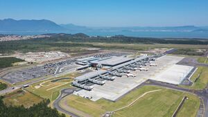
Florianópolis is served by Hercílio Luz International Airport for both domestic and international flights.[28] It is one of the leading airports in Brazil for charter flights, especially during the summer months and from destinations such as Santiago, Montevideo, Buenos Aires and Córdoba, besides domestic routes. The traffic has grown significantly at the airport and therefore the city plans to upgrade and expand the airport so that 2.7 million passengers can be accommodated annually. The architectural design of the expansion was chosen by a public competition held by Infraero in partnership with the Brazilian Architects Institute (IAB). Among the over 150 original entries, the proposal of São Paulo architect Mário Bizelli was chosen. Normally the projects for expansion and modernization of the 66 airports administered by Infraero are done by public tender based on the needs, criteria and conditions presented by the company's engineering area. On days when one of the two the local football (soccer) teams plays at home in a stadium near the airport, traffic comes to a complete standstill, often preventing vehicles from departing the airport itself.[بحاجة لمصدر] People with departing flights are advised to check the local football schedule to ensure they arrive at the airport on time.[بحاجة لمصدر]
قاعدة القوات الجوية
Florianópolis Air Force Base - BAFL, a base of the Brazilian Air Force, is located in Florianópolis.
المسافات
- برازيليا: 1673 كم؛
- Rio de Janeiro: 1,145 kilometres (711 mi);
- São Paulo: 700 kilometres (430 mi);
- Porto Alegre: 466 kilometres (290 mi);
- Curitiba: 300 kilometres (190 mi).
- Montevideo: 1,253 kilometres (779 miles);
- Asunción: 1,264 kilometres (785 miles);
- Buenos Aires: 1,753 kilometres (1,089 miles)
الرياضة
There are two professional football teams in the city. The derby between them is known as "O Clássico da Capital" ("The Capital's Classic").
البلدات التوأم – المدن الشقيقة
Florianópolis is twinned with:[29]
 Angra do Heroísmo, Portugal
 Asunción, Paraguay
 Constitución, Chile
 Córdoba, Argentina
 Fernando de la Mora, Paraguay
 Havana, Cuba
 Luján, Argentina
 Ponta Delgada, Portugal
 Praia da Vitória, Portugal
 Presidente Franco, Paraguay
 Roanoke, United States
المراجع
- ^ IBGE 2020
- ^ "Atlas do Desenvolvimento Humano no Brasil". 17 يوليو 2015. Archived from the original on 8 يوليو 2015. Retrieved 17 يوليو 2015.
- ^ "| Human Development Reports". hdr.undp.org. Retrieved 2021-04-10.
- ^ King, Tayfun (2 أكتوبر 2009). "Brazil's bid for tech-powered economy". BBC Click. British Broadcasting Corporation. Archived from the original on 20 ديسمبر 2014. Retrieved 3 ديسمبر 2014.
- ^ Sherwood, Seth (8 يناير 2009). "The Place to Be: Florianópolis, Brazil". The New York Times. Archived from the original on 6 ديسمبر 2013. Retrieved 3 ديسمبر 2014.
- ^ Foroohar, Rana (2 يوليو 2006). "The Ten Most Dynamic Cities". Newsweek. Archived from the original on 13 نوفمبر 2014. Retrieved 3 ديسمبر 2014.
- ^ "Veja o que fazer em Florianópolis e se encante!". Mundo Positivo (in البرتغالية). 11 أبريل 2014. Archived from the original on 4 أبريل 2015. Retrieved 3 ديسمبر 2014.
- ^ De Vries, Alexandra; Blore, Shawn (2012). Frommer's Brazil. [CollinsGem]. p. 438. ISBN 978-1118086063.
- ^ Menezes, Cacau (2020-12-14). "Ilha da Magia: encantos e belezas para todos os gostos". ND+ (in البرتغالية). Grupo Record. Retrieved 2021-09-19.
- ^ "The magic island". Centro de Informática e Automação do Estado de Santa Catarina. Archived from the original on 23 March 2012. Retrieved 3 December 2014.
- ^ (in pt)Unidade de Conservação: Reserva Biológica Marinha do Arvoredo, MMA: Ministério do Meio Ambiente, http://sistemas.mma.gov.br/cnuc/index.php?ido=relatorioparametrizado.exibeRelatorio&relatorioPadrao=true&idUc=214, retrieved on 27 April 2016
- ^ (in pt)Parque Estadual da Serra do Tabuleiro, FATMA: Fundação do meio Ambiente, http://www.fatma.sc.gov.br/conteudo/parque-estadual-da-serra-do-tabuleiro, retrieved on 11 June 2016
- ^ (in pt)Parque Estadual do Rio Vermelho, FATMA: Fundação do Meio Ambiente, http://www.fatma.sc.gov.br/conteudo/parque-estadual-do-rio-vermelho, retrieved on 2017-01-21
- ^ أ ب "Normais Climatológicas Do Brasil 1981–2010" (in البرتغالية). Instituto Nacional de Meteorologia. Archived from the original on 5 September 2014. Retrieved 14 October 2018.
- ^ "Station Florianópolis" (in الفرنسية). Meteo Climat. Retrieved 14 October 2018.
- ^ Brand, Donald D. (1941). "A Brief History of Anthropology in Brazil". New Mexico Anthropologist. 5 (4): 99–150. doi:10.1086/newmexianthr.5.4.4291250. ISSN 0734-7030. JSTOR 4291250. S2CID 161022821.
- ^ "Florianópolis | Brazil". Encyclopedia Britannica (in الإنجليزية). Retrieved 2021-04-10.
- ^ Prates, Marcos. "As capitais mais (e menos) evangélicas do Brasil". Exame.
- ^ Economy of Florianópolis – City Hall Website Archived 10 يونيو 2008 at the Wayback Machine
- ^ Santana, Guilherme (2003). "Tourism Development in Coastal Areas - Brazil: Economic, Demand and Environmental Issues". Journal of Coastal Research: 85–93. ISSN 0749-0208. JSTOR 40928752.
- ^ de Oliveira, Lisete Assen (2003). "The Seafront Area on the Island of Santa Catarina: Appropriation and Configuration in the Expansion of the City of Florianópolis". Journal of Coastal Research: 509–515. ISSN 0749-0208. JSTOR 40928802.
- ^ "Florianópolis - A ilha da tecnologia - Região ganha status de Vale do Silício brasileiro". Dinheiro na Web (in البرتغالية). Archived from the original on 6 April 2003. Retrieved 3 December 2014.
- ^ Brazilians and Argentines in Floripa – City Hall Website Archived 4 ديسمبر 2008 at the Wayback Machine
- ^ Information Technology in Floripa – City Hall Website Archived 4 ديسمبر 2008 at the Wayback Machine
- ^ GDP (PDF) (in البرتغالية). Florianópolis, Brazil: IBGE. 2005. ISBN 85-240-3919-1. Archived from the original (PDF) on 2 أكتوبر 2008. Retrieved 18 يوليو 2007.
- ^ per capita income (PDF) (in البرتغالية). Florianópolis, Brazil: IBGE. 2005. ISBN 85-240-3919-1. Archived from the original (PDF) on 2 أكتوبر 2008. Retrieved 18 يوليو 2007.
- ^ "Turismo em Florianópolis: saiba o que fazer na ilha de Santa Catarina". pureviagem.com.br. Archived from the original on 27 أغسطس 2017. Retrieved 28 أبريل 2018.
- ^ "Aeroporto Internacional de Florianópolis/Hercílio Luz" (in البرتغالية). Infraero. Archived from the original on 28 يناير 2015. Retrieved 3 ديسمبر 2014.
- ^ "Leis de Florianópolis SC - Busca por palavra chave". leismunicipais.com.br (in البرتغالية البرازيلية). Retrieved 2021-08-24.
قالب:Municipalities of Santa Catarina قالب:Santa Catarina MesoRegion Grande Florianopolis
- Pages using gadget WikiMiniAtlas
- CS1 البرتغالية-language sources (pt)
- CS1 الفرنسية-language sources (fr)
- CS1 البرتغالية البرازيلية-language sources (pt-br)
- Short description is different from Wikidata
- Pages using multiple image with auto scaled images
- Coordinates on Wikidata
- صفحات تستخدم جدول مستوطنة بقائمة محتملة لصفات المواطن
- Articles with unsourced statements from March 2019
- Articles with hatnote templates targeting a nonexistent page
- Florianópolis
- Populated places established in 1726
- 1726 establishments in Brazil


