ساؤون ولوار (إقليم فرنسي)
الساؤون واللوار
Saône-et-Loire | |
|---|---|
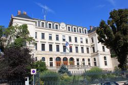
 Prefecture building of the Saône-et-Loire department, in Mâcon | |
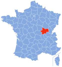
 Location of Saône-et-Loire in France | |
| الإحداثيات: 46°40′N 04°42′E / 46.667°N 4.700°E | |
| البلد | فرنسا |
| المنطقة | بورگون-فرانش-كومته |
| عاصمة الإقليم | Mâcon |
| مراكز الدوائر | Autun Chalon-sur-Saône Charolles Louhans |
| الحكومة | |
| • President of the General Council | André Accary |
| المساحة | |
| • الإجمالي | 8٬575 كم² (3٬311 ميل²) |
| التعداد (2007) | |
| • الإجمالي | 571٬193 |
| • الترتيب | 43nd |
| • الكثافة | 67/km2 (170/sq mi) |
| منطقة التوقيت | UTC+1 (CET) |
| • الصيف (التوقيت الصيفي) | UTC+2 (CEST) |
| رقم الإقليم | 71 |
| الدوائر الادارية | 5 |
| Cantons | 57 |
| Communes | 573 |
| ^1 French Land Register data, which exclude estuaries, and lakes, ponds, and glaciers larger than 1 km2 | |
ساؤون ولوار بالفرنسية Saône-et-Loire , أحد أقاليم فرنسا, سمي بهذا الاسم لمرور نهري ساؤون و اللوار في أراضيه.
. . . . . . . . . . . . . . . . . . . . . . . . . . . . . . . . . . . . . . . . . . . . . . . . . . . . . . . . . . . . . . . . . . . . . . . . . . . . . . . . . . . . . . . . . . . . . . . . . . . . . . . . . . . . . . . . . . . . . . . . . . . . . . . . . . . . . . . . . . . . . . . . . . . . . . . . . . . . . . . . . . . . . . . .
التاريخ
| Year | Pop. | ±% p.a. |
|---|---|---|
| 1801 | 452٬673 | — |
| 1806 | 471٬236 | +0.81% |
| 1821 | 498٬057 | +0.37% |
| 1831 | 524٬180 | +0.51% |
| 1841 | 551٬543 | +0.51% |
| 1851 | 574٬720 | +0.41% |
| 1861 | 582٬137 | +0.13% |
| 1872 | 598٬344 | +0.25% |
| 1881 | 625٬589 | +0.50% |
| 1891 | 619٬523 | −0.10% |
| 1901 | 620٬360 | +0.01% |
| 1911 | 604٬446 | −0.26% |
| 1921 | 554٬816 | −0.85% |
| 1931 | 538٬741 | −0.29% |
| 1936 | 525٬676 | −0.49% |
| 1946 | 506٬749 | −0.37% |
| 1954 | 511٬182 | +0.11% |
| 1962 | 535٬772 | +0.59% |
| 1968 | 550٬364 | +0.45% |
| 1975 | 569٬810 | +0.50% |
| 1982 | 571٬852 | +0.05% |
| 1990 | 559٬413 | −0.27% |
| 1999 | 544٬893 | −0.29% |
| 2006 | 549٬359 | +0.12% |
| 2016 | 555٬023 | +0.10% |
| source:[1] | ||
When it was formed during the French Revolution, as of March 4, 1790 in fulfillment of the law of December 22, 1789, the new department combined parts of the provinces of southern Burgundy and Bresse, uniting lands that had no previous common history nor political unity and which have no true geographical unity. Thus its history is that of Burgundy, and is especially to be found in the local histories of Autun, Mâcon, Chalon-sur-Saône, Charolles and Louhans.
الجغرافيا
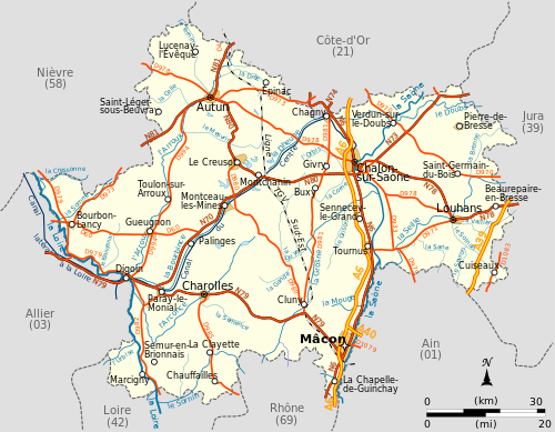
Saône-et-Loire is the seventh largest department of France. It is part of the region Bourgogne-Franche-Comté. In the west, the department is composed of the hills of the Autunois, the region around Autun, in the southwest the Charollais, and the Mâconnais in the south.
البلدات الرئيسية
| Rank | Commune | Canton | Arrondissement | Population |
|---|---|---|---|---|
| 1 | Chalon-sur-Saône | Chalon-sur-Saône-1 Chalon-sur-Saône-2 Chalon-sur-Saône-3 |
Chalon-sur-Saône | 45,166 |
| 2 | Mâcon | Mâcon-1 Mâcon-2 |
Mâcon | 33,350 |
| 3 | Le Creusot | Le Creusot-1 Le Creusot-2 |
Autun | 22,308 |
| 4 | Montceau-les-Mines | Montceau-les-Mines | Autun | 18,969 |
| 5 | Autun | Autun-1 Autun-2 |
Autun | 13,863 |
التقسيمات
The department consists of five arrondissements:
There are 29 cantons in the department and 567 communes.
السياسة
النواب الحاليون في الجمعية الوطنية
السياحة
Touristic sites :
- Roche de Solutré,
- Charolles,
- Abbaye de Cluny,
- Taizé and Taizé Community
- Dompierre-les-Ormes (Galerie européenne de la forêt et du bois, Arboretum de Pézanin).
Lake of Pézanin
انظر أيضاً
- Mâcon - Capital
- Cantons of the Saône-et-Loire department
- Communes of the Saône-et-Loire department
- Arrondissements of the Saône-et-Loire department
المصادر
وصلات خارجية
- (بالفرنسية) General Council website
- (بالفرنسية) Prefecture website
- (إنگليزية) Saone-et-Loire at the Open Directory Project
- ^ Site sur la Population et les Limites Administratives de la France
- ^ "Insee - Populations légales 2013". Insee. Retrieved September 11, 2016.
- ^ http://www.assemblee-nationale.fr/


