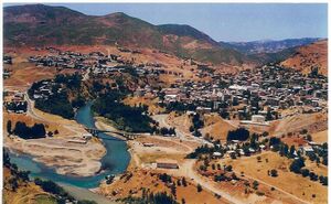
تونجايلي
تونجايلي
Dêrsim Tunceli | |
|---|---|
| T.C. Tunceli Belediyesi | |
 تونجايلي في وادي منظور | |
| الإحداثيات: 39°06′N 39°33′E / 39.100°N 39.550°E | |
| البلد | |
| المحافظة | محافظة تونجايلي |
| القضاء | قضاء تونجايلي |
| الحكومة | |
| • المختار | فاتح محمد ماچوغلو (TKP) |
| المساحة | |
| • District | 881٫76 كم² (340٫45 ميل²) |
| المنسوب | 940 m (3٬085 ft) |
| التعداد (2012)[2] | |
| • Urban | 31٬469 |
| • District | 35٬898 |
| • كثافة District | 41/km2 (110/sq mi) |
| منطقة التوقيت | UTC+3 (TRT) |
| الرمز البريدي | 62000 |
| مفتاح الهاتف | 0428 |
| Licence plate | 62 |
| الموقع الإلكتروني | http://www.tunceli.bel.tr |
تونجايلي (كردي: Dêrsim,[3] Zazaki: Mamekîye[4]) هي عاصمة محافظة تونجايلي تقع في تركيا ويبلغ تعداد سكانها حوالي 25,041 نسمة.
أصل الاسم
تونجايلي تعني أرض (إيل) البرونز (تونچ) بالتركية، بينما الاسم القديم للمحافظة، “رسيم” (أو دسيم)، ويعني باب (در) و فضة (سيم) بالكردية. وثمة سجال سياسي لا ينتهي حول إذا ما كان اسم البلدة هو تونجايلي أو درسيم. السلطات المحلية قررت أن تسميها رسيم في مايو 2019، بينما والي المحافظة أن ذلك هو ضد القانون أن تسميها درسيم.[5]
الاقتصاد
The main economic activity is animal breeding. Wheat is the only notable agricultural product. There are chromium salt and marble deposits. But only salt is produced. There are a few factories based on agriculture.[6]
المناخ
تتسم تونجايلي بمناخ قاري (تصنيف كوپن للمناخ) جاف صيفاً: Dsa) بصيف جاف شديد الحرارة وشتاء بارد متجمد ومثلِج.
| Climate data for تونجايلي (1960-2012) | |||||||||||||
|---|---|---|---|---|---|---|---|---|---|---|---|---|---|
| Month | Jan | Feb | Mar | Apr | May | Jun | Jul | Aug | Sep | Oct | Nov | Dec | Year |
| Record high °C (°F) | 14.2 (57.6) |
18.1 (64.6) |
26.0 (78.8) |
32.2 (90.0) |
36.6 (97.9) |
39.0 (102.2) |
43.5 (110.3) |
43.5 (110.3) |
40.3 (104.5) |
35.6 (96.1) |
27.0 (80.6) |
21.7 (71.1) |
43.5 (110.3) |
| Mean daily maximum °C (°F) | 2.7 (36.9) |
4.5 (40.1) |
10.9 (51.6) |
17.9 (64.2) |
23.9 (75.0) |
29.9 (85.8) |
35.0 (95.0) |
35.2 (95.4) |
30.5 (86.9) |
22.7 (72.9) |
13.4 (56.1) |
5.5 (41.9) |
19.3 (66.8) |
| Daily mean °C (°F) | −2.0 (28.4) |
−0.4 (31.3) |
5.6 (42.1) |
11.9 (53.4) |
17.1 (62.8) |
22.7 (72.9) |
27.3 (81.1) |
26.9 (80.4) |
21.6 (70.9) |
14.7 (58.5) |
6.9 (44.4) |
1.0 (33.8) |
12.8 (55.0) |
| Mean daily minimum °C (°F) | −5.8 (21.6) |
−4.6 (23.7) |
0.8 (33.4) |
6.2 (43.2) |
10.2 (50.4) |
14.5 (58.1) |
18.9 (66.0) |
18.4 (65.1) |
13.3 (55.9) |
8.2 (46.8) |
2.0 (35.6) |
−2.4 (27.7) |
6.6 (44.0) |
| Record low °C (°F) | −30.3 (−22.5) |
−29.0 (−20.2) |
−24.7 (−12.5) |
−7.1 (19.2) |
−0.1 (31.8) |
5.3 (41.5) |
9.2 (48.6) |
7.7 (45.9) |
2.6 (36.7) |
−4.0 (24.8) |
−16.4 (2.5) |
−25.6 (−14.1) |
−30.3 (−22.5) |
| Average precipitation mm (inches) | 127.2 (5.01) |
109.0 (4.29) |
111.2 (4.38) |
108.4 (4.27) |
70.1 (2.76) |
19.0 (0.75) |
3.7 (0.15) |
2.9 (0.11) |
13.9 (0.55) |
65.0 (2.56) |
104.9 (4.13) |
139.6 (5.50) |
874.9 (34.46) |
| Average precipitation days | 11.9 | 12.1 | 13.0 | 13.8 | 12.2 | 5.2 | 1.5 | 1.2 | 2.6 | 8.4 | 9.6 | 11.8 | 103.3 |
| Mean monthly sunshine hours | 105.4 | 112.0 | 167.4 | 192.0 | 279.0 | 336.0 | 368.9 | 350.3 | 291.0 | 213.9 | 150.0 | 93.0 | 2٬658٫9 |
| Source: Devlet Meteoroloji İşleri Genel Müdürlüğü [7] | |||||||||||||
انظر أيضاً
الهامش
- ^ "Area of regions (including lakes), km²". Regional Statistics Database. Turkish Statistical Institute. 2002. Retrieved 2013-03-05.
- ^ "Population of province/district centers and towns/villages by districts - 2012". Address Based Population Registration System (ABPRS) Database. Turkish Statistical Institute. Retrieved 2013-02-27.
- ^ adem Avcıkıran (2009). Kürtçe Anamnez Anamneza bi Kurmancî (PDF) (in التركية and الكردية). p. 56. Retrieved 17 December 2019.
- ^ "Mamekîye de konferansê terteleyê Dêrsimî" (in Zazaki). 21 November 2010. Retrieved 2 February 2020.
- ^ "A short history of Turkification: From Dersim to Tunceli". Ahval (in الإنجليزية). Retrieved 2020-01-20.
- ^ "TUNCELİ - Ekonomik Faaliyetler". www.cografya.gen.tr.
- ^ "Archived copy". Archived from the original on 2011-04-30. Retrieved 2011-03-19.
{{cite web}}: CS1 maint: archived copy as title (link)
- Pages using gadget WikiMiniAtlas
- CS1 التركية-language sources (tr)
- CS1 الكردية-language sources (ku)
- CS1 foreign language sources (ISO 639-2)
- Short description is different from Wikidata
- Coordinates on Wikidata
- Articles containing كردي-language text
- Pages using Lang-xx templates
- Articles containing Zazaki-language text
- محافظة تونجايلي
- مدن تركيا
- منطقة شرق الأناضول
- تونجايلي
- Populated places in Tunceli Province
- Districts of Tunceli Province
- Kurdish settlements in Turkey

