خرمآباد
خرمآباد
خرمآباد Khorramabad | |
|---|---|
مدينة | |
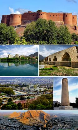
 صورة مجمعة لخرمآباد، تجاه عقارب الساعة: قلعة فلك الأفلاك، بحيرة كيو، جسر شاپوري، صورة لمدينة خرمآباد، منارة بريك، صورة پانورامية لخرمآباد. | |
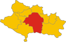
 موقع خرمآباد في محافظة لرستان | |
| الإحداثيات: 33°29′16″N 48°21′21″E / 33.48778°N 48.35583°E | |
| البلد | |
| المحافظة | لرستان |
| المقاطعة | خرمآباد |
| البخش | الوسطى |
| المنسوب | 1٬147 m (3٬763 ft) |
| التعداد (2006) | |
| • الإجمالي | 328٬544 |
| منطقة التوقيت | UTC+3:30 (توقيت إيران) |
| • الصيف (التوقيت الصيفي) | UTC+4:30 (توقيت إيران الصيفي) |
| الموقع الإلكتروني | www.Khorramabad.ir |
خرمآباد النطق (فارسية: خرمآباد - Khorram Abād, لري: خورمووه - Xurrmoa؛ مرومنة أيضاً Khorramābād، Khoramabad، Khurramabad، Khorram Abad و Khur Ramābād)[1]، هي مدينة وعاصمة محافظة لرستان، إيران. حسب تعداد 2006، كان عدد سكانها 328.544 نسمة، ضمن 75.945 أسرة.[2] تقع خرمآباد في جبال زاگروس. مطار خرمآباد يقع على بعد 3 كم جنوب المدينة.
غالبية سكان المدينة من اللور، اللاك، على الرغم من تقارب المجموعتين السكانيتين.[3] بالرغم من أنها ليست وجهة سياحية رئيسية، إلا أنها تضم المناظر الخلابة والمعالم السياحية المتعددة، مثل مواقع الكهوف السكنية الخمسة التي تعود إلى العصر الحجري القديم.[4] في وسط الدينة، توجد قلعة عملاقة تسمى فلك الأفلاك، من مخلفات العصر الساساني، وهي الآن متحف شعبي وطني.
اقتصادياً، تعتبر المدينة هي القاعدة الاقليمية لصناعات الزراعية.
التاريخ
قبل الإسلام
سيماش
During the late third millennium B.C. and early second millennium B.C., when Simashki sovereigns was ruling on عيلام, for the first time a fort was built on the peak of a natural cliff to protect the city against its enemies. Sixty hundred years later, Ellipi kings built a new fort on the ruins of the old one. Simash was the name of the place. It was the capital of Simashki dynasty.[5]
شاپورخست
في نصوص المؤرخين، شاپورخاست كانت تُعتبر واحدة من أهم مدن المنطقة وأكثرها تقدماً أثناء هذه الفترة. قلعة فلك الأفلاك ( Dež-e Shāpūr-Khwāst) بناها شاپور الأول الساساني.
العصر الإسلامي
Probably in the late seventh century CE, Shapurkhast was destroyed and the people of Shapurkhast moved to the western part of Falak-ol-Aflak Castle, which offered plenty of water as well as safety.
Hamdallah Mustawfi writes: Khorramabad was a beautiful city, now it is destroyed.
الهزارسپيان
The founder of the Hazaraspid dynasty was Abu Tahir ibn Muhammad, a descendant of the Shabankara chieftain Fadluya. Fadluya was initially a commander of the Salghurids of Fars and was appointed governor of Kuhgiluya[6] but eventually gained independence in Luristan and extended his realm as far as Isfahan. He assumed the prestigious title of atabeg.
الأسرة الصفوية
في عهد الأسرة الصفوية كانت خرمآباد مركز حكومي لرستان. In the wake of the demise of the Safavids, after the signing of the Treaty of Constantinople (1724) with Imperial Russia, the Ottomans conquered Khorramabad on 6 September 1725.[7]
الأسرة القاجارية
In this period, the city of Khorramabad was limited to environs of Falak-ol-Aflak Castle. This period was the beginning of a migration of people from small villages into Khorramabad. The increase in population led to the expansion of the city and the creation of new districts.
الأسرة الپهلوية
تأسست بلدية خرمآباد عام 1913 وكان أول مجلس للمدينة يضم سبعة أعضاء والذي تشكل عام 1916.
المناخ
| بيانات المناخ لـ خرمآباد | |||||||||||||
|---|---|---|---|---|---|---|---|---|---|---|---|---|---|
| الشهر | ينا | فب | مار | أبر | ماي | يون | يول | أغس | سبت | أكت | نوف | ديس | السنة |
| القصوى القياسية °س (°ف) | 24.0 (75.2) |
26.0 (78.8) |
31.0 (87.8) |
33.0 (91.4) |
41.0 (105.8) |
43.0 (109.4) |
47.0 (116.6) |
46.0 (114.8) |
43.0 (109.4) |
37.0 (98.6) |
30.0 (86.0) |
24.0 (75.2) |
47.0 (116.6) |
| متوسط القصوى اليومية °س (°ف) | 10.9 (51.6) |
13.3 (55.9) |
17.5 (63.5) |
22.6 (72.7) |
28.9 (84.0) |
36.0 (96.8) |
39.5 (103.1) |
39.1 (102.4) |
35.0 (95.0) |
27.7 (81.9) |
19.7 (67.5) |
13.1 (55.6) |
25.3 (77.5) |
| المتوسط اليومي °س (°ف) | 5.0 (41.0) |
7.1 (44.8) |
11.0 (51.8) |
15.7 (60.3) |
21.2 (70.2) |
27.0 (80.6) |
30.8 (87.4) |
29.8 (85.6) |
25.3 (77.5) |
19.1 (66.4) |
12.3 (54.1) |
6.9 (44.4) |
17.6 (63.7) |
| متوسط الدنيا اليومية °س (°ف) | 0.1 (32.2) |
1.4 (34.5) |
4.6 (40.3) |
8.3 (46.9) |
11.9 (53.4) |
15.4 (59.7) |
19.5 (67.1) |
18.7 (65.7) |
14.1 (57.4) |
10.0 (50.0) |
5.5 (41.9) |
1.8 (35.2) |
9.3 (48.7) |
| الصغرى القياسية °س (°ف) | −14.6 (5.7) |
−11.0 (12.2) |
−11 (12) |
−2.0 (28.4) |
−1.8 (28.8) |
7.0 (44.6) |
9.2 (48.6) |
8.0 (46.4) |
4.6 (40.3) |
−1.4 (29.5) |
−7.8 (18.0) |
−8.6 (16.5) |
−14.6 (5.7) |
| متوسط تساقط الأمطار mm (inches) | 86.0 (3.39) |
73.1 (2.88) |
82.5 (3.25) |
71.6 (2.82) |
36.5 (1.44) |
0.3 (0.01) |
0.1 (0.00) |
0.2 (0.01) |
1.2 (0.05) |
23.5 (0.93) |
54.3 (2.14) |
83.6 (3.29) |
512.9 (20.19) |
| Average rainy days | 11.9 | 10.7 | 12.9 | 11.0 | 6.2 | 0.4 | 0.3 | 0.2 | 0.4 | 4.8 | 7.6 | 10.1 | 76.5 |
| متوسط الرطوبة النسبية (%) | 69 | 64 | 58 | 54 | 43 | 28 | 24 | 25 | 28 | 39 | 55 | 66 | 46.1 |
| Mean monthly ساعات سطوع الشمس | 163.4 | 170.8 | 187.2 | 206.0 | 264.2 | 340.4 | 347.2 | 330.1 | 302.7 | 257.3 | 191.4 | 160.5 | 2٬921٫2 |
| [بحاجة لمصدر] | |||||||||||||
المعالم الرئيسية
قلعة فلك الأفلاك
گرداب سانگي
منارة بريك
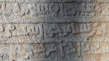
الحجر المنقوش
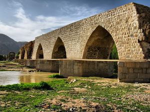
جسر شاپوري
الجامعات والكليات
مشاهير المدينة
- نصر الله كسريان (و. 1944) - مصور
- Masoud Rayegan (و. 1954) - ممثل
- Houshang Azami lorestani (و. 1936)
- Vahid Mousaeian (و. 1969) - مخرج سينمائي
- مهدي غازي (و. 1927)
- Homayoun Behzadi (و. 1942) - لاعب ومدرب كرة قدم
- Arash Kamalvand (و. 1989) - لاعب كرة طائرة
- Arash Miresmaeili (و. 1981) - judoka
- Bijan Koushki (و. 1979) - لاعب كرة قدم
- Gholamreza Mohammadi (و. 1970) - مصارع
- Morteza Sepahvand (و. 1979) - ملاكم محترف
- Reza Saghaei (و. 1939) - مغني
- Faraj Alipour و. 1958) - مغني
مدن شقيقة
 ياماگتا، ياماگتا، اليابان (منذ 2009)[9]
انظر أيضاً
المصادر
- ^ خرمآباد can be found at GEOnet Names Server, at this link, by opening the Advanced Search box, entering "-3071194" in the "Unique Feature Id" form, and clicking on "Search Database".
- ^ "تعداد جمهورية إيران الإسلامية 1385 (2006)". جمهورية إيران الإسلامية. Archived from the original (Excel) on 2011-11-11.
{{cite web}}:|archive-date=/|archive-url=timestamp mismatch; 2011-09-20 suggested (help) - ^ Anonby, Erik John "Update on Luri: How many languages" JRAS (Journal of the Royal Asiatic Society) Series 3 13(2): pp. 171–197, p.183, DOI:10.1017/S1356186303003067
- ^ Baumler, Mark F. and Speth, John D. (1993) "A Middle Paleolithic Assemblage from Kunji Cave, Iran" pp. 1–74 In Olszewski, Deborah and Dibble, Harold Lewis (editors) (1993) The Paleolithic prehistory of the Zagros-Taurus The University Museum of Archaeology and Anthropology, University of Pennsylvania, Philadelphia, Pennsylvania, ISBN 978-0-924171-24-6
- ^ بهرامي، سبزی، توسلی (2017). "مکانیابي جای نام سیماش شاهک نشین الیپي در خرم آباد و امکان یکي دانستن آن با سیماشکي عیلامي". مطالعات باستان شناسی: 30.
- ^ B. Spuller,Atabakan-e Lorestan[dead link], Encyclopædia Iranica.
- ^ Somel, Selcuk Aksin (2003). Historical Dictionary of the Ottoman Empire. Scarecrow Press. p. xlvi. ISBN 978-0810866065.
- ^ "Khoram Abad Climate Normals 1961-1990". National Oceanic and Atmospheric Administration. Retrieved December 28, 2012.
- ^ "لرستان و یاماگاتای ژاپن خواهرخوانده شدند" (in Persian). iran.
{{cite web}}: Unknown parameter|trans_title=ignored (|trans-title=suggested) (help)CS1 maint: unrecognized language (link)
وصلات خارجية
- CS1 errors: archive-url
- Articles with dead external links from December 2017
- CS1 errors: unsupported parameter
- Short description is different from Wikidata
- Pages using gadget WikiMiniAtlas
- Pages using infobox settlement with unknown parameters
- Pages using infobox settlement with image map1 but not image map
- Articles containing فارسية-language text
- Articles with unsourced statements from September 2011
- أماكن مأهولة في مقاطعة خرمآباد
- مدن إيران
- مدن محافظة لرستان
- عواصم محافظات إيران


