الپرانس
| The Pyrenees Mountains | |
|---|---|
| إسپانية: Pirineos فرنسية: Pyrénées قطلان: Pirineus أراگونية: Pirineus أوكسيتان: Pirenèus باسكية: Pirinioak, Auñamendiak | |
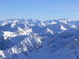 الپرانس الوسطى | |
| أعلى نقطة | |
| القمة | آنـِتو |
| الارتفاع | 3,404 m (11,168 ft) |
| الإحداثيات | 42°37′56″N 00°39′28″E / 42.63222°N 0.65778°E |
| الأبعاد | |
| الطول | 491 km (305 mi) |
| التسمية | |
| أصل الكلمة | مسماة على اسم Pyrene |
| الجغرافيا | |
| البلدان | |
| نطاق الإحداثيات | 42°40′N 1°00′E / 42.667°N 1.000°E |
| الجيولوجيا | |
| عمر الصخر | |
| نوع الصخر | |
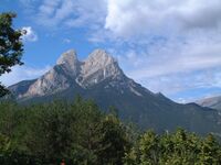
جبال البَرانس Pyrenees هي سلسلة جبلية تكوِّن حدودًا طبيعية بين فرنسا وإسبانيا. وتمتد هذه الجبال إلى نحو 435كم من خليج بسكاي حتى البحر المتوسط. تغطي هذه الجبال مساحة أكثر من 52,000 كم²، ويبلغ متوسط ارتفاعها 1,070م. ولكن بعض القمم في السلسلة الرئيسية ترتفع لأكثر من 3,000م. وتمثل قمة پيكو ده أنـِتو أعلى ارتفاع حيث يبلغ ارتفاعها 3,404م.[1]
تنتشر الحقول الجليدية على المنحدرات الشمالية من البرانس، وتحتوي الجبال على معادن الحديد والرصاص والفضة والكوبالت. ومن الصناعات المزدهرة في أسبانيا صناعة استخراج خام الحديد قرب بلباو في الجبال التي تنتهي عند خليج بسكاي. كما تُوجد بالجبال غابات من خشب التنوب والصنوبر والبلوط.
للجزء الأعظم، تشكل القشرة الأرضية الرئيسية فاصلاً بين إسپانيا وفرنسا، مع انحصار الدولة الضئيلة أندورا بينهما. وتاريخياً، يمتد تاج أراگون و مملكة نڤاره على جانبي سلسلة الجبال.[2][3]
وتمثل الجبال عائقًا للتجارة البرية، ولذا اضطرت أسبانيا وفرنسا طوال عدة سنوات إلى جعل معظم المبادلات التجارية بينهما تتم عن طريق البحر، وقد شُقَّت طرق عديدة عبر الجبال يتخللها خطان للسكك الحديدية: الأول بين بو في فرنسا وساراگوسا (سرقسطة) في أسبانيا عبر نفق كانفرانك. أما الخط الحديدي الثاني فهو بين تولوز في فرنسا وبين برشلونة في أسبانيا. ويسير هذا الخط صاعدًا إلى ارتفاع 1,580م عبر أكثر من أربعين نفقًا، وعلى مدى 92كم. وقد أقيم العديد من المنتجعات على المنحدرات الشمالية. وتقع أندورا أصغر إمارة على المنحدر الجنوبي من البرانس الشرقية، أما الباسك فهم يعيشون في البرانس الغربية.
أصل الاسم
في الأساطير اليونانية، Pyrene is a princess who gave her name to the Pyrenees. The Greek historian Herodotus says Pyrene is the name of a town in Celtic Europe.[4] According to Silius Italicus,[5] she was the virgin daughter of Bebryx, a king in Mediterranean Gaul by whom the hero Hercules was given hospitality during his quest to steal the cattle of Geryon[6] during his famous Labours. Hercules, characteristically drunk and lustful, violates the sacred code of hospitality and rapes his host's daughter. Pyrene gives birth to a serpent and runs away to the woods, afraid that her father will be angry. Alone, she pours out her story to the trees, attracting the attention of wild beasts who tear her to pieces.
After his victory over Geryon, Hercules passes through the kingdom of Bebryx again, finding the girl's lacerated remains. As is often the case in stories of this hero, the sober Hercules responds with heartbroken grief and remorse at the actions of his darker self, and lays Pyrene to rest tenderly, demanding that the surrounding geography join in mourning and preserve her name:[7] "struck by Herculean voice, the mountaintops shudder at the ridges; he kept crying out with a sorrowful noise 'Pyrene!' and all the rock-cliffs and wild-beast haunts echo back 'Pyrene!' … The mountains hold on to the wept-over name through the ages." Pliny the Elder connects the story of Hercules and Pyrene to Lusitania, but rejects it as fabulosa, highly fictional.[8]
Other classical sources derived the name from the Greek word for fire, باليونانية قديمة: πῦρ (IPA: /pŷːr/).[9] According to Greek historian Diodorus Siculus "in ancient times, we are told, certain herdsmen left a fire and the whole area of the mountains was entirely consumed; and due to this fire, since it raged continuously day after day, the surface of the earth was also burned and the mountains, because of what had taken place, were called the Pyrenees."[10]
Physiograpically, the Pyrenees are typically divided into three sections: the Atlantic (or Western), the Central, and the Eastern Pyrenees. Together, they form a distinct physiographic province of the larger Alpine System division.
الجغرافيا
التقسيمات السياسية
الپرانس الإسپانية هم جزء من المقاطعات التالية، من الشرق إلى الغرب: Girona, برشلونة، Lleida (كلهم في قطالونيا)، Huesca (في أراگون)، Navarra (في Navarre).
الپرانس الفرنسية are part of the following départements, from east to west: Pyrénées-Orientales (also known as Northern Catalonia), Aude, Ariège, Haute-Garonne, Hautes-Pyrénées, and Pyrénées-Atlantiques (the latter two of which include the Pyrenees National Park).
The independent principality of Andorra is sandwiched in the eastern portion of the mountain range بين الپرانس الإسپانية و الپرانس الفرنسية.

التقسيمات الفيزيوغرافية
فيزيوغرافياً، the Pyrenees may be divided into three sections: the Atlantic (or Western), the Central, and the Eastern Pyrenees. Together, they form a distinct physiographic province of the larger Alpine System division.
في الپرانس الغربية، من جبال الباسك بالقرب من خليج بسكاي في المحيط الأطلسي، the average elevation gradually increases from west to east.
تمتد الپرانس الوسطى باتجاه الشرق من ممر سومپورت إلى وادي آران, and they include the highest summits of this range:[11]
- پيكو دى أنـِتو 3,404 متر في حافة مالادِتا،[11]
- Pico Posets 3,375 متر،[11]
- مونتى پرديدو 3,355 متر.[11]
In the Eastern Pyrenees, with the exception of one break at the eastern extremity of the Pyrénées Ariégeoises في Ariège area, the mean elevation is remarkably uniform until a sudden decline occurs in the easternmost portion of the chain known as the Albères.[11]
السفوح
Most foothills of the Pyrenees are on the Spanish side, where there is a large and complex system of ranges stretching from Spanish Navarre, across northern Aragon and into Catalonia, almost reaching the Mediterranean coast with summits reaching 2,600 m (8,500 ft).[12] At the eastern end on the southern side lies a distinct area known as the Sub-Pyrenees.[13]
On the French side the slopes of the main range descend abruptly and there are no foothills except in the Corbières Massif in the northeastern corner of the mountain system.[14]
الجيولوجيا
The Pyrenees are older than the Alps: their sediments were first deposited in coastal basins during the Paleozoic and Mesozoic eras. During Ediacaran to Ordovician times, Pyrenees were located at the Northwest margin of Gondwana, where they formed a lateral continuity of neighbouring areas, such as the Montagne Noire and the Mouthoumet massifs and Southwestern territory of Sardinia.[15] Between 100 and 150 million years ago, during the Early Cretaceous Period, the Bay of Biscay fanned out, pushing present-day Spain against France and applying intense compressional pressure to large layers of sedimentary rock. The intense pressure and uplifting of the Earth's crust first affected the eastern part and moved progressively to the entire chain, culminating in the Eocene Epoch.
The eastern part of the Pyrenees consists largely of granite and gneissose rocks, while in the western part the granite peaks are flanked by layers of limestone. The massive and unworn character of the chain comes from its abundance of granite, which is particularly resistant to erosion, as well as weak glacial development.
The upper parts of the Pyrenees contain low-relief surfaces forming a peneplain. This peneplain originated no earlier than in Late Miocene times. Presumably it formed at height as extensive sedimentation raised the local base level considerably.[16]
البسيطة
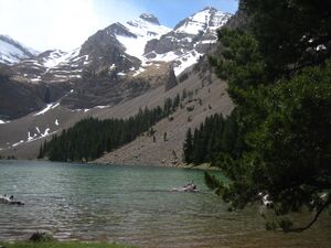
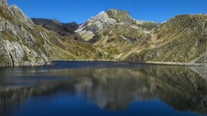
Conspicuous features of Pyrenean scenery are:
- the absence of great lakes, such as those that fill the lateral valleys of the Alps[11]
- the rarity and relative high elevation of usable passes[11]
- the large number of the mountain torrents locally called gaves, which often form lofty waterfalls, surpassed in Europe only by those of Scandinavia[11]
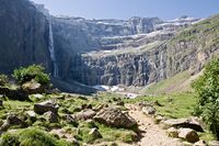
- the frequency with which the upper end of a valley assumes the form of a semicircle of precipitous cliffs, called a cirque.[11]
The highest waterfall is Gavarnie (462 m or 1,515 ft), at the head of the Gave de Pau; the Cirque de Gavarnie, in the same valley,[11] together with the nearby Cirque de Troumouse and Cirque d'Estaubé, are notable examples of the cirque formation.
Low passes are lacking, and the principal roads and the railroads between France and Spain run only in the lowlands at the western and eastern ends of the Pyrenees, near sea level. The main passes of note are:
- Col de la Perche (1,581 m (5,187 ft)), towards the east, between the valley of the Têt and the valley of the Segre,
- Col de Puymorens (1,920 m (6,300 ft)), on European route E09 between France and Spain.
- The nearby Pas de la Casa or Port d'Envalira, the highest road pass in the Pyrenees at 2,408 m (7,900 ft), and one of the highest points of the European road network, which provides the route from France to Andorra,
- The Port de la Bonaigua (2,070 m (6,790 ft)), in the middle of the range at the head of the Aran Valley.
- Plan de Beret (1,870 m (6,140 ft))
- Col du Pourtalet (1,794 m (5,886 ft)).
- The Col de Somport or Port de Canfranc (1,632 m (5,354 ft)), where there were old Roman roads.
- Col de la Pierre St Martin (1,766 m (5,794 ft))
- Puerto de Larrau (1,578 m (5,177 ft))
- The Roncevaux Pass (1,057 m (3,468 ft)), entirely in Navarre (Spain) is an important point on the Camino de Santiago pilgrimage route.
Because of the lack of low passes a number of tunnels have been created, beneath the passes at Somport, Envalira, and Puymorens and new routes in the center of the range at Bielsa and Vielha.
A notable visual feature of this mountain range is La Brèche de Roland, a gap in the ridge line, which – according to legend – was created by Roland.
Natural resources
The metallic ores of the Pyrenees are not in general of much importance now, though there were iron mines at several locations in Andorra, as well as at Vicdessos in Ariège, and the foot of Canigou in Pyrénées-Orientales long ago. Coal deposits capable of being profitably worked are situated chiefly on the Spanish slopes, but the French side has beds of lignite.[11] The open pit of Trimoun near the commune of Luzenac (Ariège) is one of the greatest sources of talc in Europe.
There are many marble quarries in the Pyrenees, most of which were opened by the Romans in ancient times. Quarried intermittently, they provided prestigious marbles such as Grand Antique (used in Rome and Constantinople by the Romans), statuary white marbles as well as coloured marbles used to decorate the royal palaces of the Louvre and Versailles in France and the Royal Palace of Madrid in Spain.[17][18]
Mineral springs are abundant and remarkable, and especially noteworthy are the hot springs. The hot springs, among which those of Les Escaldes in Andorra, Panticosa and Lles in Spain, Ax-les-Thermes, Bagnères-de-Luchon and Eaux-Chaudes in France may be mentioned, are sulfurous and mostly situated high, near the contact of the granite with the stratified rocks. The lower springs, such as those of Bagnères-de-Bigorre (Hautes-Pyrénées), Rennes-les-Bains (Aude), and Campagne-sur-Aude (Aude), are mostly selenitic and not hot.[11]
المناخ


يغلب على البيرِنيه مناخ معتدل جبلي لطيف في الشتاء معتدل في الصيف، أمطاره سنوية مع حد أدنى في الصيف. يراوح متوسط حرارة كانون الثاني بين 3 و4 درجات) على ارتفاع 500-600م، وتنخفض إلى - 8- - 9درجات على ارتفاع 2900م، ويرتفع متوسط تموز إلى 18-23 درجة عند أقدام الجبال و6 - 7 درجات على ارتفاع 2900م. وتتلقى السفوح الشمالية أمطاراً تتراوح بين 1500-2000 مم/السنة، وتنخفض على السفوح الجنوبية إلى النصف. ويغلب على الأقسام الغربية من جبال البيرِنيه مناخ بحري رطب، تصل كمية الأمطار فيها إلى (1400-1800مم/السنة). أما في الشرق فيسيطر مناخ البحر المتوسط الجاف صيفاً، وأمطاره في حدود (500-750مم/السنة). تؤلف أنهار البيرِنيه المجاري العليا لأنهار الإبرو والغارون وآدور. وهي دائمة الجريان على مدار السنة، أوديتها عميقة وخانقية، تتسع في مناطق الصخور الطرية، وذات مقاطع طولية شديدة الانحدار صالحة لبناء محطات كهرمائية، كما هي الحال على السفوح الفرنسية، كما توجد في البيرنيه بحيرات صغيرة من أصل جليدي.
التسمية
ما كان يسمى في الفترة الأندلسية بجبل البرانس هو جبل قرب قرطبة سكنه بعض الداخلين إلى الأندلس من المغاربة البرانس[19] وفي التراث العربي نجد تسميات أخرى لهذه السلاسل تختلف عن التسمية الحالية وهي البرينو [20] وهيكل الزهرة وجبل البرتات [21]
الحياة النباتية والحيوانية
تعد السفوح الشمالية أكثر غنى بالغابات من السفوح الجنوبية. وتتعاظم خصائص النبات من نموذج البحر المتوسط من الغرب إلى الشرق، كما تتزايد المساحات القفراء بالاتجاه نفسه. وتغلب الغابات المؤلفة من شجر البلوط دائم الخضرة وأشجار الماكي والغاريغ في الجنوب والشرق، حتى ارتفاع 600-700م، وتغلب التربة البنية المميزة لحوض البحر المتوسط على نطاق واسع. أما على السفوح الغربية والشمالية فتغلب الغابات ذات الأوراق العريضة والأشجار النفضية (المتساقطة الأوراق) وترب الغابات الداكنة. وتنتشر غابات السرو في القسم الشمالي للسفوح الجبلية. أما على الأجزاء العليا للنطاق الغابي الجبلي، فتغلب غابات الزان والشوح والتنوب المختلطة. تليها باتجاه القمم (1800-2000م) المروج الألبية وشبه الألبية.
الديموغرافيا

يعتمد السكان علـى زراعة التبغ والحبوب والعنب والخضراوات، وتربية الخيول والأبقار بأعداد قليلة، وتقتصر الصناعة على تصنيع التبغ وإنتاج الطاقة الكهرمائية وتعبئة المياه المعدنية. كما تعتمد البلاد في مواردها على السياحة القائمة على نظام الضرائب غير المباشرة. إذ يبلغ عدد السياح نحو 10 ملايين سائح في السنة. وتوجد فيها شبكة طرق مواصلات جيدة وفنادق فخمة. ويدعم الميزانية العامة الرسوم والضرائب على البضائع وتجارة الفحم، كما ربطت الأقاليم بشبكة بريدية وهاتفية جيدة.
انظر أيضاً
الهوامش
المصادر
- Paegelow, Claus (2008). Pyrenäen Bibliografie. Andorra, spanische & französische Pyrenäen, Pyrenees Bibliography. Andorra, Spain & French Pyrenees (in German and English). Verlag Claus Paegelow. ISBN 978-3-00-023936-6.
{{cite book}}: CS1 maint: unrecognized language (link)
تحوي هذه المقالة معلومات مترجمة من الطبعة الحادية عشرة لدائرة المعارف البريطانية لسنة 1911 وهي الآن من ضمن الملكية العامة.
المراجع
- ^ Barnolas, A. y Pujalte, V. (2004). «La Cordillera Pirenaica». Vera Torres, J. A. (ed.), ed. Geología de España. Sociedad Geológica de España e Instituto Geológico y Minero de España. pp. 231-343. ISBN 84-7840-546-1.
- ^ Preamble of the "Charter of the Catalan Language" Archived 2009-03-25 at the Wayback Machine
- ^ Collins Road Atlas of Europe. London: Harper Collins. 1995. pp. 28–29. ISBN 0-00-448148-8.
- ^ Herodotus, Histories 2.33. Archived 2012-04-04 at the Wayback Machine
- ^ Silius Italicus, Punica 3.415–441.
- ^ Although Geryon was usually located in the mythical west of the setting sun, he was also associated with Iberia; according to Strabo, his triple-body was preserved at Cadiz in the form of a tree.
- ^ Ben Tipping, Exemplary Epic: Silius Italicus' Punica (Oxford University Press, 2010), pp. 20–21 online.
- ^ Pliny the Elder, Natural History 3.3. Archived 2012-10-14 at the Wayback Machine
- ^ Dictionary of Greek and Roman Geography (1854) William Smith, LLD, Ed.[1]
- ^ Diodorus Siculus, The Library of History Vol III, 35 [2]
- ^ أ ب ت ث ج ح خ د ذ ر ز س خطأ استشهاد: وسم
<ref>غير صحيح؛ لا نص تم توفيره للمراجع المسماةEB1911 - ^ Pirineus-Prepirineus Archived 2008-07-23 at the Wayback Machine
- ^ Jordi Sacasas i Lluís, Geografia de Catalunya, Publicacions L'Abadia de Montserrat. ISBN 978-84-8415-915-5
- ^ Christophe Neff : Les Corbières maritimes – forment-elles un étage de végétation méditerranéenne thermophile masqué par la pression humaine ? In: Eric Fouache (Edit.): The Mediterranean World Environment and History. IAG Working Group on Geo-archeology, Symposium Proceedings. Environmental Dynamics and History in Mediterranean Areas, Paris, Université de Paris – Sorbonne 24 – 26 avril 2002. Paris, 2003, 191 – 202, (Elsevier France, ISBN 2-84299-452-3).
- ^ Padel Maxime, Sébastien Clausen, Marc Poujol, José-Javier Alvaro (2022). "Shifts in the Ediacaran to Lower Ordovician sedimentary zircon provenances of Northwest Gondwana: the Pyrenean files". Geologica Acta (in الإنجليزية). 20 (14): 2. doi:10.1344/GeologicaActa2022.20.14.
{{cite journal}}: CS1 maint: multiple names: authors list (link) - ^ Babault, Julien; Van Den Driessche, Jean; Bonnet, Stephanie; Castelltort, Sébastien; Crave, Alain (2005). "Origin of the highly elevated Pyrenean peneplain". Tectonics. 24 (2): n/a. Bibcode:2005Tecto..24.2010B. doi:10.1029/2004TC001697.
- ^ Pascal Julien, Marbres, de carrières en palais (Marbles, from quarries to palaces), Le Bec en l'air editor, 2006.
- ^ María Luisa Tárraga Baldó, Marble in the Palace of Madrid's decoration: Origins and impacts, Bulletin du Centre de recherche du château de Versailles (Bulletin of the Research Centre of the Château de Versailles), 2013.
- ^ معجم البلدان ياقوت الحموي الصفحة : 358
- ^ الكتاب : نزهة المشتاق في اختراق الآفاق المؤلف : الادريسي
- ^ نزهة المشتاق في اختراق الآفاق الإدريسي الصفحة : 236
وصلات خارجية
"Pyreneans Echoes" by SoundFiction, free concrete landscape music from the "Parc National des Hautes Pyrénées", (free download) http://soundcloud.com/soundfiction
- Virtual Tours of the Pyrenees
- (إنگليزية) Official website of France's Pyrenees National Park
- Bardenas Reales desert (Spain Pyrenees desert)
- Flying over the Pyrenees
- Skiing in the Pyrenees
- Great Routes: Pirineos, from a website of the Instituto de Turismo de España
- Glaciers of the Spanish Pyrenees
- The small Yellow Train (Petit Train Jaune) over Pont Séjourné near Font-Romeu
- Complete guide to the Pyrenees
- Guide to the Pyrenees mountains of Spain, Andorra, and France.
- Pages using gadget WikiMiniAtlas
- Short description is different from Wikidata
- Articles containing إسپانية-language text
- Pages using Lang-xx templates
- Articles containing فرنسية-language text
- Articles containing قطلان-language text
- Articles containing أراگونية-language text
- Articles containing أوكسيتان (بعد 1500)-language text
- Articles containing باسكية-language text
- Coordinates on Wikidata
- Wikidata value to be checked for Infobox mountain
- Articles containing Ancient Greek (to 1453)-language text
- Articles with hatnote templates targeting a nonexistent page
- مقالات مأخوذة من الطبعة الحادية عشرة لدائرة المعارف البريطانية
- الپرانس
- سلاسل جبال اوروبا
- Mountain ranges of France
- Mountain ranges of Spain
- Landforms of Andorra
- Geography of Aragon
- Ariège
- Geography of the Basque Country
- Geography of Catalonia
- Haute-Garonne
- Hautes-Pyrénées
- Pyrénées-Atlantiques
- Pyrénées-Orientales
- Green Spain
- أقاليم فيزيوغرافية


