محافظة أنقرة
محافظة أنقرة
Ankara ili | |
|---|---|
 Ankara Skyline | |
 موقع محافظة أنقرة في تركيا | |
| الإحداثيات: 39°36′N 32°30′E / 39.600°N 32.500°E | |
| البلد | |
| المنطقة | غرب الأناضول |
| المنطقة الفرعية | أنقرة |
| الحكومة | |
| • الدائرة الانتخابية | أنقرة |
| • المحافظ | واثپ شاهين |
| المساحة | |
| • إجمالي | 25٫706 كم² (9٫925 ميل²) |
| التعداد (2020)[1] | |
| • إجمالي | 5٫663٫322 |
| • الكثافة | 0٫22/km2 (0٫57/sq mi) |
| مفتاح الهاتف | 0312 |
| لوحة السيارة | 06 |
محافظة أنقرة Ankara Province (تركية: Ankara ili)، هي إحدى محافظات تركيا، وتقع في منطقة وسط الأناضول، وسط تركيا. عاصمتها، مدينة أنقرة. أُطلق اسم أنقرة أيضاً على إحدى ولايات الدولة العثمانية، وكانت تغطي مساحة أكبر من المحافظة الحالية.
التاريخ
 أنقرة، عاصمة محافظة أنقرة. |
موقع المدينة الحديثة كان مقراً لمستوطنات للعديد من الحضارات الأناضولية التاريخية في القِدم وفي الأزمنة الكلاسيكية، بما فيهم فريگ والليديون والفرس والإسكندر الأكبر والرومان و الگلاتا. مدينة أنقرة أصبحت معقلاً حصيناً للبيزنطيين؛ ثم سقطت في أيدي الأتراك السلاجقة ولاحقاً الدولة العثمانية. وأخيراً اختارها مصطفى كمال أتاتورك والحركة القومية التركية كمقر الحكومة المؤقتة و البرلمان التركي في 1920، وفي 1923 كعاصمة جمهورية تركيا حديثة التأسيس.
الديموغرافيا
| |||||||||||||||||||||||||||||||||||||||
المقاطعات
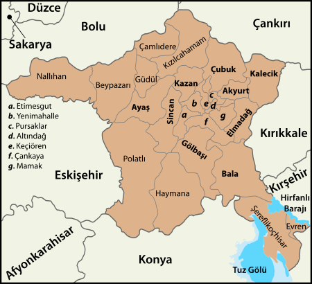
Ankara has 25 districts.[4]
| Number Plates (İlçe Kayıt) |
District | Population (31.12.2021) |
Area (km²) | Density (per km²) |
|---|---|---|---|---|
| 1872 | Akyurt | 38,588 | 212.16 | 182 |
| 1130 | Altındağ | 407,675 | 174.53 | 2,336 |
| 1157 | Ayaş | 13,093 | 1,111.74 | 12 |
| 1167 | Bala | 22,966 | 2,562.94 | 9 |
| 1187 | Beypazarı | 48,393 | 1,814.36 | 27 |
| 1227 | Çamlıdere | 8,350 | 632.63 | 13 |
| 1231 | Çankaya | 949,265 | 267.61 | 3,547 |
| 1260 | Çubuk | 91,363 | 1,361.60 | 67 |
| 1302 | Elmadağ | 44,236 | 568.07 | 78 |
| 1922 | Etimesgut | 606,472 | 49.19 | 12,329 |
| 1924 | Evren | 2,965 | 179.74 | 16 |
| 1744 | Gölbaşı | 142,961 | 738.30 | 194 |
| 1365 | Güdül | 8,155 | 383.65 | 21 |
| 1387 | Haymana | 27,298 | 2,983.56 | 9 |
| 1815 | Kahramankazan | 57,913 | 407.83 | 142 |
| 1427 | Kalecik | 12,502 | 1,340.46 | 9 |
| 1745 | Keçiören | 942,884 | 189.88 | 4,966 |
| 1473 | Kızılcahamam | 26,968 | 1,760.76 | 15 |
| 1746 | Mamak | 682,420 | 478.40 | 1,426 |
| 1539 | Nallıhan | 26,961 | 1,972.51 | 14 |
| 1578 | Polatlı | 127,526 | 3,465.81 | 37 |
| 2034 | Pursaklar | 159,676 | 251.52 | 635 |
| 1747 | Sincan | 561,411 | 344.26 | 1,631 |
| 1658 | Şereflikoçhisar | 33,475 | 2,127.79 | 16 |
| 1723 | Yenimahalle | 703,809 | 274.16 | 2,567 |
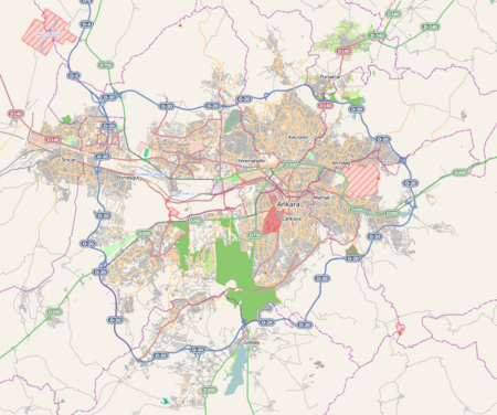
| ANKARA City (9 districts / urban)[5] Altındağ, Çankaya, Etimesgut, Gölbaşı, Keçiören, Mamak, Pursaklar, Sincan, Yenimahalle |
5,156,573 [6] | 2,767.85 [7] | 1,863 | |
| TOTAL | 5,747,325 [6] | 25,653.46 [8][7] | 224 | |
قالب:Turkey province population/Ankara
الجغرافيا
Ankara is mostly in the Central Anatolia region, and partly in the Black Sea region. Ankara has mountain forests to its north, and the dry plain of Konya to its south. The province is irrigated by the Kızılırmak and Sakarya River systems, the Sarıyar reservoir and many natural lakes and pools. 50% of the land is used for agriculture, 28% is forest and another 10% is meadow and grazing land. Lake Tuz, the second largest lake in Turkey, partly lies in the Şereflikoçhisar district of the province. The highest point of the province is the 2,015 meters tall Işık Mountain in the Kızılcahamam district.
المناخ
The climate is hot and dry in summer, rainy in spring and autumn, cold and snowy in winter, wetter in the north of the province than the drier plains to the south. The annual precipitation in the city of Ankara located the center of the province is 415 mm (1.362 ft),[9] the annual precipitation of Kızılcahamam located in the north of the province is 592 mm (1.942 ft), and the annual precipitation of Şereflikoçhisar located in the southeast of the province is 357 mm (1.171 ft).[10][11]
انظر أيضاً
المصادر
- ^ أ ب "The Results of Address Based Population Registration System, 2020". Turkish Statistical Institute. Archived from the original on 2021-10-28. Retrieved 7 December 2021.
- ^ Genel Nüfus Sayımları
- ^ tuik
- ^ "The Results of Address Based Population Registration System, 31-12-2017". Turkish Statistical Institute. Retrieved 1 February 2018.
- ^ "TURKEY: Ankara City". Citypopulation.de.
{{cite web}}: CS1 maint: url-status (link) - ^ أ ب خطأ استشهاد: وسم
<ref>غير صحيح؛ لا نص تم توفيره للمراجع المسماةPopulation of Turkey - ^ أ ب "Area of regions (including lakes), km²". Regional Statistics Database. Turkish Statistical Institute. 2002. Retrieved 2013-03-05.
- ^ خطأ استشهاد: وسم
<ref>غير صحيح؛ لا نص تم توفيره للمراجع المسماةAnkara.Province - ^ "Ankara" (in التركية). Turkish State Meteorological Service. Retrieved 8 January 2016.
- ^ "Kizilcahamam-Turkey". Weatherbase. Retrieved 14 October 2013.
- ^ "Coğrafi Yapı". Sereflikochisar.gov.tr. Archived from the original on 22 October 2007. Retrieved 10 October 2014.


