ڤيلا ڤليا
(تم التحويل من Vila Velha)
20°20′11″S 40°17′37″W / 20.33639°S 40.29361°W
ڤيلا ڤليا
Vila Velha | |
|---|---|
بلدية | |
| بلدية ڤيلا ڤليا | |
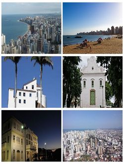
 'من الأعلى ، في اتجاه عقارب الساعة: منظر ڤيلا ڤليا من دير پنيا؛ پرايا دا كوستا؛ كنيسة المسبحة؛ منظر ڤيلا ڤليا من دير پنيا؛ متحف السكك الحديدية؛ دير پنيا. | |
| الكنية: The Land of the Green Shins (بالبرتغالية: Terra dos Canelas-Verdes) | |
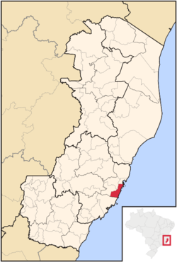
 الموقع في ولاية إسپريتو سانتو | |
| البلد | |
| المنطقة | Southeast |
| الولاية | |
| تأسست | 23 مايو 1535 |
| الحكومة | |
| • العمدة | Max Filho (PSDB) |
| المساحة | |
| • الإجمالي | 208 كم² (80 ميل²) |
| التعداد (2010) | |
| • الإجمالي | 427٬579 |
| • الكثافة | 1٬906/km2 (4٬940/sq mi) |
| منطقة التوقيت | UTC-3 (UTC-3) |
| Postal Code | 29100-000 |
| مفتاح الهاتف | +55 27 |
| الموقع الإلكتروني | Vila Velha, Espírito Santo |
ڤيلا ڤليا (Vila Velha ؛ [ˈvilɐ ˈvɛʎɐ]؛ في البرتغالية تعني "البلدة القديمة") هي بلدة ساحلية في إسپريتو سانتو، البرازيل. وتقع في مقابل ڤيتوريا، عاصمة الولاية. وبلغ عدد سكانها 396,323 (في 2005) ومساحتها 208.82 كم².[1]
الموقع
Vila Velha forms part of the Greater Vitória metropolitan area. To the north is Vitória, to the west Cariacica and Viana, to the south Guarapari, and to the east the Atlantic Ocean.
References
- ^ IBGE - "Archived copy". Archived from the original on January 9, 2007. Retrieved August 3, 2014.
{{cite web}}: Unknown parameter|deadurl=ignored (|url-status=suggested) (help)CS1 maint: archived copy as title (link)

