مقاطعة رپاهانوك، ڤرجينيا
(تم التحويل من Rappahannock County, Virginia)
Rappahannock County | |
|---|---|
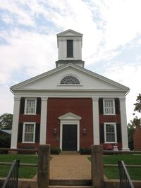
 Rappahannock County Courthouse in Washington, Virginia | |
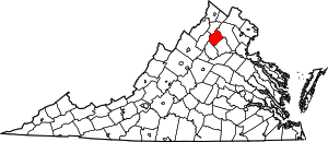
 الموقع ضمن ولاية Virginia | |
 موقع Virginia ضمن الولايات المتحدة | |
| الإحداثيات: 38°41′N 78°10′W / 38.69°N 78.17°W | |
| البلد | |
| State | |
| تأسست | 1833 |
| السمِيْ | Rappahannock River |
| Seat | Washington |
| Largest town | Washington |
| المساحة | |
| • الإجمالي | 267 ميل² (690 كم²) |
| • البر | 266 ميل² (690 كم²) |
| • الماء | 0٫8 ميل² (2 كم²) 0.3% |
| التعداد (2010) | |
| • الإجمالي | 7٬373 |
| • Estimate (2018)[1] | 7٬252 |
| • الكثافة | 28/sq mi (11/km2) |
| منطقة التوقيت | UTC−5 (Eastern) |
| • الصيف (التوقيت الصيفي) | UTC−4 (EDT) |
| Congressional district | 5th |
| الموقع الإلكتروني | rappahannockcountyva |
مقاطعة رپاهانوك إنگليزية: Rappahannock County هي إحدى المقاطعات في ولاية ڤرجينيا في الولايات المتحدة.
المقاطعات المجاورة
- Warren County, Virginia – شمال غرب
- Fauquier County, Virginia – شمال شرق
- Culpeper County, Virginia – جنوب شرق
- Madison County, Virginia – جنوب غرب
- Page County, Virginia – غرب
منطقة محمية وطنية
- Shenandoah National Park (part)
الجبال
The summits of the following mountains are located within Rappahannock County:
- Pignut Mountain
- Hogback Mountain
- Castleton Mountain
- Jenkins Mountain
- Jefferson Mountain
- Meetinghouse Mountain
- Little Mulky Mountain
- Little Jenkins Mountain
- Googe Mountain
- Round Mountain
- Hickerson Mountain
- Fork Mountain
- Battle Mountain [2]
- Little Battle Mountain
- Piney Ridge
- Pickerel Ridge
- Poes Mountain
- Turkey Mountain
- Aaron Mountain
- Red Oak Mountain

U.S. Route 211 as it passes through Rappahannock County; the Blue Ridge Mountains can be seen in the distance.
الطرق السريعة
الديمغرافيا
| التعداد التاريخي | |||
|---|---|---|---|
| التعداد | Pop. | %± | |
| 1840 | 9٬257 | — | |
| 1850 | 9٬782 | 5٫7% | |
| 1860 | 8٬850 | −9٫5% | |
| 1870 | 8٬261 | −6٫7% | |
| 1880 | 9٬291 | 12٫5% | |
| 1890 | 8٬678 | −6٫6% | |
| 1900 | 8٬843 | 1٫9% | |
| 1910 | 8٬044 | −9�0% | |
| 1920 | 8٬070 | 0٫3% | |
| 1930 | 7٬717 | −4٫4% | |
| 1940 | 7٬208 | −6٫6% | |
| 1950 | 6٬112 | −15٫2% | |
| 1960 | 5٬368 | −12٫2% | |
| 1970 | 5٬199 | −3٫1% | |
| 1980 | 6٬093 | 17٫2% | |
| 1990 | 6٬622 | 8٫7% | |
| 2000 | 6٬983 | 5٫5% | |
| 2010 | 7٬373 | 5٫6% | |
| 2018 (تق.) | 7٬252 | [1] | −1٫6% |
| Decennial Census[3] 1790–1960[4] 1900–1990[5] 1990–2000[6] | |||
الحكم
مجلس النظار
- Debbie Donehey (D) – Vice-Chair (Wakefield District)
- Christine Smith (R) – Chair (Piedmont)
- I. Christopher Parrish (R) – (Stonewall-Hawthorne District)
- Keir Whitson (R) – (Hampton District)
- Ron Frazier (R) – (Jackson District)
Politics
Presidential elections results
| Year | Republican | Democratic | Third parties |
|---|---|---|---|
| 2016 | 56.6% 2,539 | 39.0% 1,747 | 4.4% 197 |
| 2012 | 53.0% 2,311 | 45.4% 1,980 | 1.5% 66 |
| 2008 | 50.6% 2,227 | 47.8% 2,105 | 1.7% 73 |
| 2004 | 53.6% 2,172 | 45.4% 1,837 | 1.0% 41 |
| 2000 | 52.7% 1,850 | 41.6% 1,462 | 5.7% 201 |
| 1996 | 47.3% 1,505 | 44.2% 1,405 | 8.5% 271 |
| 1992 | 44.3% 1,410 | 40.0% 1,273 | 15.7% 498 |
| 1988 | 61.7% 1,657 | 37.3% 1,003 | 1.0% 26 |
| 1984 | 62.7% 1,696 | 36.9% 999 | 0.4% 12 |
| 1980 | 49.8% 1,179 | 44.6% 1,055 | 5.6% 133 |
| 1976 | 44.5% 881 | 54.1% 1,071 | 1.5% 29 |
| 1972 | 68.2% 1,055 | 30.5% 471 | 1.4% 21 |
| 1968 | 43.6% 594 | 28.9% 394 | 27.5% 375 |
| 1964 | 39.8% 449 | 59.9% 675 | 0.3% 3 |
| 1960 | 43.7% 426 | 55.8% 544 | 0.5% 5 |
| 1956 | 47.8% 514 | 48.7% 523 | 3.5% 38 |
| 1952 | 54.4% 619 | 45.5% 518 | 0.2% 2 |
| 1948 | 30.1% 311 | 59.7% 617 | 10.3% 106 |
| 1944 | 37.3% 297 | 62.4% 497 | 0.4% 3 |
| 1940 | 27.6% 225 | 72.1% 588 | 0.4% 3 |
| 1936 | 26.0% 241 | 73.9% 686 | 0.1% 1 |
| 1932 | 17.2% 124 | 81.9% 590 | 0.8% 6 |
| 1928 | 39.1% 329 | 60.9% 513 | |
| 1924 | 17.6% 89 | 78.2% 395 | 4.2% 21 |
| 1920 | 33.3% 210 | 66.4% 418 | 0.3% 2 |
| 1916 | 17.1% 84 | 81.5% 401 | 1.4% 7 |
| 1912 | 19.8% 94 | 75.1% 356 | 5.1% 24 |
التجمعات
البلدة
Census-designated places
Other unincorporated communities
- Amissville
- Boston
- Castleton
- Huntly
- Laurel Mills
- Massies Corner
- Peola Mills
- Revercombs Corner
- Sperryville
- Wakefield Manor
- Woodville
انظر أيضاً
الهامش
- ^ أ ب "Population and Housing Unit Estimates". Retrieved July 14, 2019.
- ^ "A Gallium Anomaly Utilized in Palaeogeographic Reconstruction of Battle Mountain, Rappahannock County, Virginia". Kansas Academy of Science. 2016-04-01. Retrieved 2016-07-14.
- ^ "U.S. Decennial Census". United States Census Bureau. Retrieved January 5, 2014.
- ^ "Historical Census Browser". University of Virginia Library. Retrieved January 5, 2014.
- ^ "Population of Counties by Decennial Census: 1900 to 1990". United States Census Bureau. Retrieved January 5, 2014.
- ^ "Census 2000 PHC-T-4. Ranking Tables for Counties: 1990 and 2000" (PDF). United States Census Bureau. Retrieved January 5, 2014.
- ^ Leip, David. "Dave Leip's Atlas of U.S. Presidential Elections". uselectionatlas.org. Retrieved 10 April 2018.
وصلات خارجية
- Rappahannock County, Virginia, the county government homepage
- Blue Ridge Independent News, an online local newspaper
- Rappahannock News, a print and online newspaper
- Memorial Foundation of the Germanna Colonies in Virginia, Inc.
- Rappahannock Historical Society, 328 Gay Street, Washington, VA 22747
- Library of Virginia Website

|
Fauquier County | Warren County | 
| |
| Page County | ||||
| Culpeper County | Madison County |
الكلمات الدالة:
تصنيفات:
- Pages using gadget WikiMiniAtlas
- Short description is different from Wikidata
- Coordinates on Wikidata
- مقاطعات Virginia
- Pages using infobox U.S. county with unknown parameters
- Articles containing إنگليزية-language text
- Pages using Lang-xx templates
- Jct template errors
- Pages using US Census population needing update
- مقاطعة رپاهانوك، ڤرجينيا
- Virginia counties
- Northern Virginia counties
- Washington metropolitan area
- 1833 establishments in Virginia
- Populated places established in 1833
- مقاطعات ڤرجينيا


