شرق إنگلترة
شرق إنگلترة East of England | |
|---|---|
 | |
| دولة ذات سيادة | المملكة المتحدة |
| البلد المكوّن | إنگلترة |
| أكبر مدينة | نورتش |
| مقاطعات | بدفوردشاير كمبردجشاير إسكس هرتفوردشاير نورفوك سفوك |
| الحكومة | |
| • Leaders' board | East of England Local Government Association |
| المساحة | |
| • الإجمالي | 19٬120 كم² (7٬380 ميل²) |
| ترتيب المساحة | 2nd |
| التعداد (2011) | |
| • الإجمالي | 5٬847٬000 |
| • الترتيب | 4th |
| • الكثافة | 310/km2 (790/sq mi) |
| GVA | |
| • Total | £146 billion |
| • Per capita | £23,970 (3rd) |
| ITL code | TLH |
| ONS code | E12000006 |
| الموقع الإلكتروني | www |
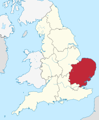
شرق إنگلترة East of England، هو أحد الأقاليم الإنگليزية التسعة الرسمية من المستوى الأول لأغراض إحصائية. تأسست عام 1994 وعُينت للاحصائيات من عام 1999. وتضم مقاطعات إسكس، هرتفوردشاير، بدفوردشاير، كمبردجشاير، نورفوك، وسفوك. وإسكس هي أكبر مقاطعة من حيث عدد السكان.
في تعداد 2011 وصل عدد سكان الاقليم إلى 5,847,000 نسمة.[1]
الجغرافيا
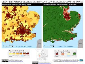
The East of England region has the lowest elevation range in the UK. Twenty percent of the region is below mean sea level, most of this in North Cambridgeshire, Norfolk and on the Essex Coast.[2][3] Most of the remaining area is of low elevation, with extensive glacial deposits.[4] The Fens, a large area of reclaimed marshland, are mostly in North Cambridgeshire.[5] The Fens include the lowest point in the country in the village of Holme: 2.75 metres (9.0 ft) below mean sea level. This area formerly included the body of open water known as Whittlesey Mere. The highest point in the region is at Clipper Down at 817 ft (249 m) above mean sea level, in the far southwestern corner of the region in the Ivinghoe Hills.[6][7][8]
Communities known as New Towns, responses to urban congestion and World War II destruction, appeared in Basildon and Harlow (Essex), as well as in Stevenage and Hemel Hempstead (Hertfordshire), in the 1950s and 1960s.[9] In the late 1960s, the Roskill Commission considered Cublington in Buckinghamshire, Thurleigh in Bedfordshire, Nuthampstead in Hertfordshire and Foulness in Essex as locations for a possible third airport for London. A new airport was not built, but a former Royal Air Force base at Stansted, which had previously been converted to civilian use redeveloped and expanded in the following decades.[10]
الاستخدام التاريخي
 |
|---|
The East of England succeeded the standard statistical region East Anglia (which excluded Essex, Hertfordshire and Bedfordshire, then in the South East). The East of England civil defence region was identical to today's region.[11]
شرق أنگليا مع مقاطعات البيت
Essex, despite meaning East-Saxons, previously formed part of South East England, along with Bedfordshire and Hertfordshire, a mixture of definite and debatable Home counties. The earliest use of the term is from 1695. Charles Davenant, in An essay upon ways and means of supplying the war, wrote, "The Eleven Home Counties, which are thought in Land Taxes to pay more than their proportion..." then cited a list including these four. The term does not appear to have been used in taxation since the 18th century.[12]
المناخ
الديموغرافيا
حمل المراهقين
الحرمان
الانتخابات
الأقاليم الاحصائية في الاتحاد الأوروپي
| من المستوى 1 | الرمز | من المستوى 2 | الرمز | من المستوى 3 | الرمز |
|---|---|---|---|---|---|
| شرق إنگلترة | UKH | شرق أنگليا | UKH1 | Peterborough | UKH11 |
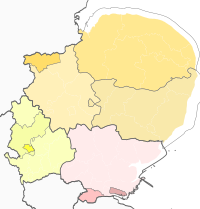
|
كمبردجشاير CC | UKH12 | |||
| نورفوك | UKH13 | ||||
| سوفوك | UKH14 | ||||
| بدفوردشاير وهرتفوردشاير | UKH2 | لوتون | UKH21 | ||
| هرتفوردشاير CC | UKH23 | ||||
| بدفورد | UKH24 | ||||
| وسط بدفوردشاير | UKH25 | ||||
| إسكس | UKH3 | Southend-on-Sea | UKH31 | ||
| ثوروك | UKH32 | ||||
| إسكس CC | UKH33 | ||||
الحكومة
الحكومة المحلية
شرق السهل الإنگليزي
الحكومة المحلية
يضم الاقليم رسمياً التقسيمات التالية:
| خريطة | Ceremonial county | Shire county / unitary | Districts |
|---|---|---|---|
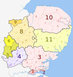 |
إسكس | 1. ثوروك U.A. | |
| 2. Southend-on-Sea U.A. | |||
| 3. إسكس | a) هارلو, b) Epping Forest, c) Brentwood, d) Basildon, e) Castle Point, f) Rochford, g) Maldon, h) Chelmsford, i) Uttlesford, j) Braintree, k) Colchester, l) Tendring | ||
| 4. هرتفوردشاير | a) الأنهار الثلاثة، b) Watford, c) Hertsmere, d) Welwyn Hatfield, e) Broxbourne, f) East Hertfordshire, g) Stevenage, h) North Hertfordshire, i) St Albans, j) Dacorum | ||
| بدفوردشاير | 5. لوتون U.A. | ||
| 6. بدفورد U.A. | |||
| 7. وسط بدفوردشاير U.A. | |||
| كمبردجشاير | 8. Cambridgeshire | a) كمبردج, b) South Cambridgeshire, c) Huntingdonshire, d) فنلاند, e) East Cambridgeshire | |
| 9. Peterborough U.A. | |||
| 10. Norfolk | a) نورويتش, b) جنوب نوفوك, c) Great Yarmouth, d) Broadland, e) North Norfolk, f) King's Lynn and West Norfolk, g) Breckland | ||
| 11. Suffolk | a) Ipswich, b) Suffolk Coastal, c) Waveney, d) Mid Suffolk, e) Babergh, f) St. Edmundsbury, g) Forest Heath | ||
التاريخ
الحرب العالمية الثانية
الإرث العلمي
الإرث الصناعي
الثقافة
الاقتصاد
هرتفوردشاير


بدفوردشاير


شرق أنگليا


إسكس/لندن الكبرى
النقل
سياسة النقل
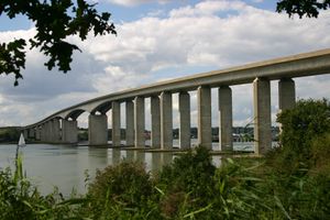
الطرق
السكك الحديدية
البحري
النقل الجوي
التعليم
الجامعات
الاعلام المحلي
انظر أيضاً
- شرق إنگلترة (دائرة انتخابية في البرلمان الاوروپي)
- الطاقم الاستراتيجي المحلي لشرق إنگلترة
- وكالة تنمية شرق إنگلترة
- أقاليم إنگلترة
- شرق أنگليا
قوائم:
المصادر
- ^ "2011 Census - Population and Household Estimates for England and Wales, March 2011" (PDF). Office of National Statistics. 2012. Retrieved 2012-07-16.
- ^ "A Summary of Climate Change To coincide with the publication of the UK Climate Change Risk Assessment (CCRA) 2012 Risks for the East of England" (PDF). Retrieved 22 August 2020.
- ^ "Norfolk topographic map, elevation, relief". topographic-map.com (in الإنجليزية). Retrieved 2020-08-22.
- ^ "East Anglia | region, England, United Kingdom". Encyclopedia Britannica (in الإنجليزية). Retrieved 2020-08-05.
- ^ "Fens | marshland, England, United Kingdom". Encyclopedia Britannica (in الإنجليزية). Retrieved 2020-08-05.
- ^ "Holme Fen | The Great Fen". www.greatfen.org.uk. Retrieved 2020-08-05.
- ^ "Whittlesey Mere | The Great Fen". www.greatfen.org.uk. Retrieved 2020-08-05.
- ^ Ltd, Copyright The mountain Guide-A.-Connect. "Clipper Down | England". UK mountain Guide (in الإنجليزية). Archived from the original on 29 October 2020. Retrieved 2020-08-05.
- ^ "Celebrating 70 Years of the New Towns Act". Town and Country Planning Association (in الإنجليزية). Retrieved 2020-08-25.
- ^ Roskill Commission on the Third London Airport (in الإنجليزية).
- ^ Haslam, Jeremy (January 2011). "Daws Castle, Somerset, and Civil Defence Measures in Southern and Midland England in the Ninth to Eleventh Centuries". Archaeological Journal (in الإنجليزية). 168 (1): 195–226. doi:10.1080/00665983.2011.11020834. ISSN 0066-5983. S2CID 161250564.
- ^ Home counties#In official use
وصلات خارجية
- Government's list of councils in the East of England
- Office for National Statistics
- Government Office for the East of England
- East of England Development Agency
- Official Visitor site for the East of England
- Offiical Film and TV locations website for the East of England
- East of England Tourism
- East of England Regional Assembly
- East of England International
- East of England Business Community Directory


