خط العرض 1° جنوباً

(تم التحويل من 1st parallel south)
Line across the Earth
خط العرض 1st جنوب
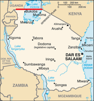
يشكل خط العرض 1° جنوباً معظم الحدود الشمالية لتنانيا مع أوغندا، وقطاع قصير من حدودها مع كينيا.

خط العرض 1° جنوباً (إنگليزية: 1st parallel south)، هي دائرة عرض بزاوية (69.2 ميل/111.36 كيلومتر) جنوب خط الإستواء. تمر دائرة العرض عبر المحيط الأطلسي، أفريقيا، المحيط الهندي، جنوب شرق آسيا، أستراسيا، المحيط الهادي، وأمريكا الجنوبية.

يُحدد خط العرض معظم الحدود بين أوغندا وتنزانيا، وقطاع صغير للغاية من الحدود بين كينيا وتنزانيا]].[1]

. . . . . . . . . . . . . . . . . . . . . . . . . . . . . . . . . . . . . . . . . . . . . . . . . . . . . . . . . . . . . . . . . . . . . . . . . . . . . . . . . . . . . . . . . . . . . . . . . . . . . . . . . . . . . . . . . . . . . . . . . . . . . . . . . . . . . . . . . . . . . . . . . . . . . . . . . . . . . . . . . . . . . . . .

حول العالم

بدءاً من خط الزوال الرئيسي، في الاتجاه الشرقي، يمر خط العرض 1° جنوباً عبر:

الإحداثيات البلد، الإقليم، أو البحر ملاحظات
1°0′S 0°0′E / 1.000°S 0.000°E / -1.000; 0.000 (Prime Meridian) Atlantic Ocean
1°0′S 8°52′E / 1.000°S 8.867°E / -1.000; 8.867 (Gabon) Gabon
1°0′S 14°25′E / 1.000°S 14.417°E / -1.000; 14.417 (Republic of the Congo) Republic of the Congo
1°0′S 17°20′E / 1.000°S 17.333°E / -1.000; 17.333 (Democratic Republic of the Congo) Democratic Republic of the Congo
1°0′S 29°35′E / 1.000°S 29.583°E / -1.000; 29.583 (Uganda) Uganda
1°0′S 30°45′E / 1.000°S 30.750°E / -1.000; 30.750 (Uganda / Tanzania Border) Uganda / Tanzania border Mostly in Lake Victoria
1°0′S 33°56′E / 1.000°S 33.933°E / -1.000; 33.933 (Kenya / Tanzania Border) Kenya / Tanzania border A short section of the border (about 11 km (6.8 mi)), entirely within Lake Victoria
1°0′S 34°1′E / 1.000°S 34.017°E / -1.000; 34.017 (Kenya) Kenya Passing about 30 km (19 mi) north of the capital, Nairobi
1°0′S 41°7′E / 1.000°S 41.117°E / -1.000; 41.117 (Somalia) Somalia
1°0′S 42°2′E / 1.000°S 42.033°E / -1.000; 42.033 (Indian Ocean) Indian Ocean Passing just south of Addu Atoll, Maldives
1°0′S 98°39′E / 1.000°S 98.650°E / -1.000; 98.650 (Indonesia) Indonesia Island of Siberut
1°0′S 98°56′E / 1.000°S 98.933°E / -1.000; 98.933 (Mentawai Strait) Mentawai Strait
1°0′S 100°21′E / 1.000°S 100.350°E / -1.000; 100.350 (Indonesia) Indonesia Island of Sumatra - passing just south of Padang
1°0′S 103°59′E / 1.000°S 103.983°E / -1.000; 103.983 (Karimata Strait) Karimata Strait
1°0′S 109°27′E / 1.000°S 109.450°E / -1.000; 109.450 (Indonesia) Indonesia Islands of Maya Karimata and Borneo
West Kalimantan
Central Kalimantan
East Kalimantan
Future capital of Indonesia
1°0′S 117°8′E / 1.000°S 117.133°E / -1.000; 117.133 (Makassar Strait) Makassar Strait
1°0′S 119°28′E / 1.000°S 119.467°E / -1.000; 119.467 (Indonesia) Indonesia Island of Sulawesi
1°0′S 120°30′E / 1.000°S 120.500°E / -1.000; 120.500 (Gulf of Tomini) Gulf of Tomini
1°0′S 121°23′E / 1.000°S 121.383°E / -1.000; 121.383 (Indonesia) Indonesia Island of Sulawesi
1°0′S 122°47′E / 1.000°S 122.783°E / -1.000; 122.783 (Banda Sea) Banda Sea
1°0′S 123°12′E / 1.000°S 123.200°E / -1.000; 123.200 (Indonesia) Indonesia Island of Sulawesi
1°0′S 123°22′E / 1.000°S 123.367°E / -1.000; 123.367 (Molucca Sea) Molucca Sea
1°0′S 128°19′E / 1.000°S 128.317°E / -1.000; 128.317 (Indonesia) Indonesia Island of Damar
1°0′S 128°24′E / 1.000°S 128.400°E / -1.000; 128.400 (Halmahera Sea) Halmahera Sea
1°0′S 130°38′E / 1.000°S 130.633°E / -1.000; 130.633 (Indonesia) Indonesia Islands of Salawati and New Guinea
1°0′S 134°3′E / 1.000°S 134.050°E / -1.000; 134.050 (Cenderawasih Bay) Cenderawasih Bay
1°0′S 134°48′E / 1.000°S 134.800°E / -1.000; 134.800 (Indonesia) Indonesia Island of Numfor
1°0′S 134°57′E / 1.000°S 134.950°E / -1.000; 134.950 (Cenderawasih Bay) Cenderawasih Bay
1°0′S 135°48′E / 1.000°S 135.800°E / -1.000; 135.800 (Indonesia) Indonesia Island of Biak
1°0′S 136°8′E / 1.000°S 136.133°E / -1.000; 136.133 (Pacific Ocean) Pacific Ocean Passing just north of the atolls of Pelleluhu and Heina, Papua New Guinea
Passing just south of the Kaniet Islands, Papua New Guinea
Passing just south of Banaba Island, Kiribati
Passing between the atolls of Nonouti and Tabiteuea, Kiribati
1°0′S 91°26′W / 1.000°S 91.433°W / -1.000; -91.433 (Ecuador) Ecuador Island of Isabela
1°0′S 91°4′W / 1.000°S 91.067°W / -1.000; -91.067 (Pacific Ocean) Pacific Ocean Passing just south of the island of San Cristóbal, Ecuador
1°0′S 80°51′W / 1.000°S 80.850°W / -1.000; -80.850 (Ecuador) Ecuador Passing just south of Manta
1°0′S 75°23′W / 1.000°S 75.383°W / -1.000; -75.383 (Peru) Peru
1°0′S 74°16′W / 1.000°S 74.267°W / -1.000; -74.267 (Colombia) Colombia
1°0′S 69°25′W / 1.000°S 69.417°W / -1.000; -69.417 (Brazil) Brazil Amazonas
Roraima
Amazonas
Pará
Amapá
Pará - islands of Grande do Gurupá and Marajó
Pará - passing just north of Belém
Maranhão
1°0′S 46°11′W / 1.000°S 46.183°W / -1.000; -46.183 (Atlantic Ocean) Atlantic Ocean


انظر أيضاً

المصادر

  1. ^ Médard, H. (1 May 2019). ""The Kagera River and the Making of a Contested Boundary: Territorial Legacies and Colonial Demarcations in Buganda (19th–20th Centuries) " with Ikram Kidari". The International Journal of African Historical Studies. 52: 11–30.