كينتانا رو
Quintana Roo | |
|---|---|
| Estado Libre y Soberano de Quintana Roo | |
| النشيد: Himno a Quintana Roo | |
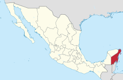
 ولاية كينتانا رو ضمن المكسيك | |
| البلد | المكسيك |
| العاصمة | Chetumal |
| أكبر مدينة | كانكون |
| البلديات | 11 |
| الانضمام | October 8, 1974[1] |
| Order | 30th |
| الحكومة | |
| • Governor | Carlos Joaquín |
| • Parliament | Congress of Quintana Roo |
| • Senators[2] | Pedro Joaquín Ludivina Menchaca José Luis García |
| • Deputies[3] | |
| المساحة | |
| • الإجمالي | 44٬705 كم² (17٬261 ميل²) |
| Ranked 19th | |
| أعلى منسوب | 230 m (750 ft) |
| التعداد (2015)[6] | |
| • الإجمالي | 1٬501٬562 |
| • الترتيب | 26th |
| • الكثافة | 34/km2 (87/sq mi) |
| • ترتيب الكثافة | 24th |
| صفة المواطن | Quintanarroense |
| منطقة التوقيت | UTC−5 (EST) |
| Postal code | 77 |
| Area code | |
| ISO 3166 code | MX-ROO |
| HDI | ▲ 0.759 high Ranked 11th |
| GDP | US$ 10,286,552.031 th[a] |
| الموقع الإلكتروني | www |
| ^ a. The state's GDP was $131,667,866 thousand of pesos in 2008,[5] amount corresponding to $10,286,552.031 thousand of dollars, being a dollar worth 12.80 pesos (value of June 3, 2010).[7] | |
كينتانا رو (Quintana Roo؛ النطق الإسپاني: [kinˈtana ˈro])، رسمياً ولاية كينتانا رو الحرة السيدة (إسپانية: Estado Libre y Soberano de Quintana Roo)، هي واحدة من 31 ولاية، مع المنطقة الاتحادية، يشكلون 32 كيان اتحادي بالمكسيك. وتنقسم إلى عشر بلديات وعاصمتها هي چتومال.
It is located in Southeastern Mexico, on the eastern part of the شبه جزيرة يوكاتان. It is bordered by the states of Campeche to the west and Yucatán to the northwest, and by the Orange Walk and Corozal districts of Belize, along with an offshore borderline with Belize District to the south. Quintana Roo has a coastline to the east with the Caribbean Sea and to the north with the Gulf of Mexico. It also claims territory which gives it a small border with Guatemala in the southwest of the state, although this disputed area is also claimed by Campeche.
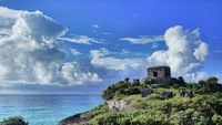
كينتانا رو تضم مدينة كانكون، جزر كوزومل و Isla Mujeres, and the towns of Bacalar, Playa del Carmen and Akumal, as well as the ancient Maya ruins of Chacchoben, Cobá, Kohunlich, موييل، تولوم، Xel-Há, and Xcaret. The Sian Ka'an biosphere reserve is also located in the state.
The state officially covers an area of 44,705 square kilometers (17,261 sq mi), but since 1997 there is a boundary dispute with the states of Yucatán and Campeche over an area of approximately 10,200 square kilometers (3,900 sq mi).[8][9]
The statewide population is expanding at a rapid rate due to the construction of hotels and the demand for workers. Many immigrants come from Yucatán, Campeche, Tabasco, and Veracruz. The state is frequently hit by severe hurricanes due to its exposed location, the most recent and severe being Hurricane Dean in 2007, which made landfall with sustained winds of 280 km/h (175 mph), with gusts up to 320 km/h (200 mph).
On February 1, 2015, Quintana Roo officially adopted a new time zone, Southeastern, which is five hours behind Coordinated Universal Time (UTC−05:00), and corresponds to Eastern Standard Time (EST).[10] Reasons cited for the change include coordination of air travel, banking operations, and more daylight hours, the latter of which will result in less energy usage.[10]
. . . . . . . . . . . . . . . . . . . . . . . . . . . . . . . . . . . . . . . . . . . . . . . . . . . . . . . . . . . . . . . . . . . . . . . . . . . . . . . . . . . . . . . . . . . . . . . . . . . . . . . . . . . . . . . . . . . . . . . . . . . . . . . . . . . . . . . . . . . . . . . . . . . . . . . . . . . . . . . . . . . . . . . .
التاريخ

الديمغرافيا
| Year | Pop. | ±% |
|---|---|---|
| 1895[11] | — | |
| 1900 | — | |
| 1910 | 9٬109 | — |
| 1921 | 10٬966 | +20.4% |
| 1930 | 10٬620 | −3.2% |
| 1940 | 18٬752 | +76.6% |
| 1950 | 26٬967 | +43.8% |
| 1960 | 50٬169 | +86.0% |
| 1970 | 88٬150 | +75.7% |
| 1980 | 225٬985 | +156.4% |
| 1990 | 493٬277 | +118.3% |
| 1995 | 703٬536 | +42.6% |
| 2000 | 874٬963 | +24.4% |
| 2005 | 1٬135٬309 | +29.8% |
| 2010 | 1٬325٬578 | +16.8% |
| 2015[12] | 1٬501٬562 | +13.3% |
النبيت والوحيش
انظر أيضاً
. . . . . . . . . . . . . . . . . . . . . . . . . . . . . . . . . . . . . . . . . . . . . . . . . . . . . . . . . . . . . . . . . . . . . . . . . . . . . . . . . . . . . . . . . . . . . . . . . . . . . . . . . . . . . . . . . . . . . . . . . . . . . . . . . . . . . . . . . . . . . . . . . . . . . . . . . . . . . . . . . . . . . . . .
الهامش
- ^ "Poder Legislativo del Estado de Quintana Roo" (PDF) (in Spanish).
{{cite news}}: CS1 maint: unrecognized language (link) - ^ "Senadores por Quintana Roo LXI Legislatura". Senado de la Republica. Retrieved April 5, 2011.
- ^ "Listado de Diputados por Grupo Parlamentario del Estado de Quintana Roo". Camara de Diputados. Retrieved April 6, 2011.
- ^ "Resumen". Cuentame INEGI. Retrieved February 12, 2013.
- ^ أ ب "Relieve". Cuentame INEGI. Retrieved April 6, 2011.
- ^ "Encuesta Intercensal 2015" (PDF). Retrieved December 8, 2015.
- ^ "Reporte: Jueves 3 de Junio del 2010. Cierre del peso mexicano". www.pesomexicano.com.mx. Retrieved August 10, 2010.
- ^ "Controversia Constitucional: Estado de Quintana Roo Vs. Estado de Yucatán (3 de Mayo de 1997)". Suprema Corte de Justicia de la Nacion. Retrieved April 6, 2011.
- ^ "Campeche insiste en que Quintana Roo le invadió terreno". Notisureste. Retrieved April 6, 2011.
- ^ أ ب "Quintana Roo estrena horario mañana (Spanish)" (in Spanish). Retrieved February 1, 2015.
{{cite web}}: CS1 maint: unrecognized language (link) - ^ "Mexico: extended population list". GeoHive. Archived from the original on March 11, 2012. Retrieved 2011-07-29.
{{cite web}}: Unknown parameter|deadurl=ignored (|url-status=suggested) (help) - ^ "Encuesta Intercensal 2015" (PDF). INEGI. Retrieved 2015-12-08.
References
- Dumond, Don E.1985 The Talking Crosses of Yucatán: A New Look at their History. Ethnohistory 32(4):291–308.
- Freidel, David., Schele, Linda., et al. 1993 Maya Cosmos: Three thousand years on the Shaman's Path. New York: W. Morrow
- Harrison, Peter D. 1985 Some Aspects of Preconquest Settlement in Southern Quintana Roo, Mexico. Lowland Maya Settlement Patterns edited by Wendy Ashmore Albuquerque: University of New Mexico Press, A School of American Research Book.
- Villa Rojas, Alfonso. 1945 The Maya of East Central Quintana Roo: The Pagan-Christian Religious Complex. Washington, D.C.: Carnegie Institution.
للاستزادة
- Anderson, E. N. and Felix Medina Tzuc. Animals and the Maya in Southeast Mexico. University of Arizona Press. Tucson, Arizona. 2005.
- Brannon, Jeffery T. and Gilbert M. Joseph. Eds. 1991 Land, labor & capital in modern Yucatán: essays in regional history and political economy. Tuscaloosa: University of Alabama Press.
- Barton Bray, David, Marcelo Carreon, Leticia Merino, and Victoria Santos. "On the Road to Sustainable Forestry: The Maya of Quintana Roo are Striving to Combine Economic Efficiency, Ecological Sustainability, and a Democratic Society." Cultural Survival Quarterly 17.1, 38-41. 1993.
- Daltabuit, Magali and Oriol Pi-Sunyer. 1990. Tourism Development in Quintana Roo, Mexico. Cultural Survival Quarterly 14.2, 9-13. http://209.200.101.189/publications/csq/csq-article.cfm?id=837
- Dumond, Don E. 1997 The Machete and the Cross. Campesino Rebellion in Yucatán. Lincoln and London: University of Nebraska Press.
- Encyclopædia Britannica 2008. Quintana Roo. Encyclopædia Britannica, Inc. Accessed 2008-02-21.
- Forero, Oscar A. and Michael R. Redclift. "The Role of the Mexican State in the Development of Chicle Extraction in Yucatán, and the Continuing Importance of Coyotaje." Journal of Latin American Studies 38.1, 65-93. 2006.
- Gabbert, Wolfgang. Becoming Maya—Ethnicity and Social Inequality in Yucatán Since 1500. University of Arizona Press. Tucson, Arizona. 2004.
- Hervik, Peter. Mayan People Within and Beyond Boundaries—Social Categories and Lived Identity in Yucatán. Harwood Academic Publishers. Amsterdam, The Netherlands. 1999.
- Jones, Grant D. Maya Resistance to Spanish Rule—Time and History on a Colonial Frontier. University of New Mexico Press. Albuquerque, New Mexico. 1989.
- Juarez, Ana M. 2002. "Ecological Degradation, Global Tourism, and Inequality: Maya Interpretations of the Changing Environment in Quintana Roo, Mexico". Human Organization 61.2, 113-124.
- Morely, Sylvanus Griswold. The Ancient Maya. Stanford University Press. Stanford, California. 1947.
- Morely, Sylvanus Griswold and George W. Brainerd. The Ancient Maya, 3rd ed. Stanford University Press. Stanford, California. 1956.
- Pi-Sunyer, Oriol and R. Brooke Thomas. 1997. Tourism, Environmentalism, and Cultural Survival in Quintana Roo. "In" Life and Death Matters: Human Rights at the End of the Millennium. Barbara R. Johnston, ed. p. 187-212. Walnut Creek, California. Altamira Press.
- Roys, Ralph L. The Political Geography of the Yucatán Maya. Carnegie Institution of Washington Publication 613. Washington, D. C. 1957.
- Rugeley, Terry. 2004 "Yaxcabá and the caste war of Yucatán: An Archaeological Perspective" In Alexander, Rani T. ed. Yaxcabá and the caste war of Yucatán Albuquerque: University of New Mexico Press
- Schlesinger, Victoria. Animals and Plants of the Ancient Maya: A Guide. University of Texas Press. Austin, Texas. 2001.
- Sharer, Robert J. The Ancient Maya, 4th ed. Stanford University Press. Stanford, California. 1983.
- Villa Rojas, Alfonso. The Maya of East Central Quintana Roo. Carnegie Institute of Washington Publication 559. Washington, D. C. 1945.
- Young, Peter A, ed. Secrets of the Maya. Hatherleigh Press. Long Island City, New York. 2003
- Link to tables of population data from Census of 2005 INEGI: Instituto Nacional de Estadística, Geografía e Informática
وصلات خارجية
 Geographic data related to كينتانا رو at OpenStreetMap
- Quintana Roo State Government (بالإسپانية)
- CS1 errors: unsupported parameter
- Short description is different from Wikidata
- Pages using infobox settlement with unknown parameters
- Pages using infobox settlement with the wikidata parameter
- Pages using infobox settlement with no coordinates
- Articles containing إسپانية-language text
- Pages using Lang-xx templates
- Quintana Roo
- States of Mexico
- Southern Mexico
- Southeastern Mexico
- Yucatán Peninsula
- 1974 establishments in Mexico
- دول وأقاليم تأسست في 1974
- ولايات المكسيك


