نهر أب
| Ob | |
|---|---|
 نهر الأب في نوڤوسيبيرسك | |
 خريطة حوض نهر الأب | |
| الاسم المحلي | Error {{native name}}: an IETF language tag as parameter {{{1}}} is required (help) |
| الموقع | |
| البلد | روسيا |
| المناطق | كراي ألطاي، أوبلاست نوڤوسيبيرسك، أوبلاست تومسك، أكروگ خانتي-مانسي الذاتي، ياماليا |
| المدن | بييسك، برناول، نوڤوسيبيرسك، نيژنى ڤارتوڤسك، سورگوت |
| السمات الطبيعية | |
| المنبع | كاتون |
| ⁃ الموقع | جبل بلوخا، جمهورية ألطاي |
| ⁃ الإحداثيات | 49°45′0″N 86°34′0″E / 49.75000°N 86.56667°E |
| ⁃ المنسوب | 2,300 متر |
| 2nd source | بييا |
| ⁃ الموقع | بحيرة تلتسكويى، جمهورية ألطاي |
| ⁃ الإحداثيات | 51°47′11″N 87°14′49″E / 51.78639°N 87.24694°E |
| ⁃ المنسوب | 434 متر |
| 3rd source | أبعد منبع: نظام أب-إرتش |
| ⁃ الموقع | بالقرب من ممر مانگ-تاي-تشيا-تا-فان، جبال ألطاي، شينجيانگ، الصين |
| ⁃ الإحداثيات | 47°52′39″N 89°58′12″E / 47.87750°N 89.97000°E |
| ⁃ المنسوب | 2,960 متر |
| Source confluence | بالقرب من بييسك |
| ⁃ الموقع | كراي ألطاي |
| ⁃ الإحداثيات | 52°25′54″N 85°01′26″E / 52.43167°N 85.02389°E |
| ⁃ المنسوب | 195 متر |
| المصب | خليج أب |
- الموقع | دلتا أب، يماليا |
- الإحداثيات | 66°32′02″N 71°23′41″E / 66.53389°N 71.39472°E |
- المنسوب | 0 متر |
| الطول | 3,700 كم |
| مساحة الحوض | 2,972,497 km2 (1,147,688 sq mi) 2,994,238 km2 (1,156,082 sq mi) |
| التدفق | |
| ⁃ الموقع | ساليخارد[1] (حجم الحوض: 2,917,508 كم²[2]) |
| ⁃ المتوسط | (فترة البيانات: 1971-2015)12,889 m3/s (455,200 cu ft/s)[3]
12,475 m3/s (440,600 cu ft/s)[4] 12,500 m3/s (440,000 cu ft/s) (فترة البيانات: 2003-2006)373 km3/a (11,800 m3/s) (فترة البيانات: 1999-2008)427 km3/a (13,500 m3/s) |
| ⁃ أدنى تدفق | 2,360 m3/s (83,000 cu ft/s) |
| ⁃ أقصى تدفق | 40,200 m3/s (1,420,000 cu ft/s) |
| التدفق | |
| ⁃ الموقع | مصب الأب، خليج أب (بحر كارا)، روسيا |
| ⁃ المتوسط | Multiannual discharge
(فترة البيانات: 1940-2017)402 km3/a (12,700 m3/s)[5] (فترة البيانات: 1984-2018)414 km3/a (13,100 m3/s) 12,692 m3/s (448,200 cu ft/s) 12,830 m3/s (453,000 cu ft/s) |
| سمات الحوض | |
| الروافد | |
| - اليسرى | كاتون، آنوي، تشاريش، Aley، پارابل, ڤاسيوگان، إرتش، سڤرنايا سوسڤا |
| - اليمنى | بييا، بيرد، إينيا، توم، تشوليم، كت، تيم, ڤخ، پيم, كازيم |
 | |
نهر أوبOb River بالروسية (Обь)، هو نهر روسي تبلغ مساحة حوضه ثلاثة ملايين كيلومتر مربع، ويمتد أيضا إلى أراضي كازاخستان ومنغوليا والصين. وهو أحد ثلاثة أكبر أنهار في سيبيريا الغربية. وهو على غرار كل من نهري إينيسـِي (Ienisseï ) ولينا (Léna) ينبع من ألطاي (Altaï) ويصب في بحر كارا، وهو يجري متخذا مسارا من الجنوب إلى الشمال.

يبلغ طول الممرات المائية الصالحة للملاحة لنهر أوب وروافده نحو 30,600 كم. ويبلغ عرض النهر في الجزء الأسفل بين 3 – 6كم، بينما يبلغ العرض عند المصب 80 كم في المتوسط. يسد الجليد مجرى النهر من أكتوبر إلى يونيو. وفي فصل الصيف، يمثِّـل النهر طريقًا مائيًا مهمًا لنقل الحبوب ومنتجات الألبان والماشية والصوف واللحوم. وتذهب الغالبية من تلك المنتجات إلى خطوط السكة الحديدية لنقلها إلى الجزء الغربي من روسيا ولكن بعضها يُصدّر عبر المحيط المتجمد الشمالي.
- يشكل مع رافده إيرتيش أحد أطول الأنهار في العالم بما يفوق 5400كم.
- وهو يسمح بالملاحة النهرية الموسمية، كما نشأت وتعيش على ضفافه العديد من المدن مثل نوڤوسيبيرسك وأومسك، التي تعتبر مراكز صناعية.
الأسماء
The internationally known name of the river is based on the Russian name Обь (Obʹ, ru). Possibly from Proto-Indo-Iranian *Hā́p-, "river, water" (compare Vedic Sanskrit áp-, Persian āb, Tajik ob, and Pashto obə, "water"). Katz (1990)[6] proposes Komi ob 'river' as the immediate source of derivation for the Russian name. Katz's proposal of a common Finno-Ugric root, borrowed early on from a pre-Indo-Iranian source related to Sanskrit ambhas- 'water' is deemed improbable by Rédei (1992),[7] who prefers to analyse this as a later loan from a descendant of the non-nasal root form *Hā́p-.
The Ob is known to the Khanty people as the As (the source of the name "Ostyak"), Yag, Kolta and Yema; to the Nenets people as the Kolta or Kuay; and to the Siberian Tatars as the Umar or Omass.[8]
الجغرافيا

The Ob forms 25 km (16 mi) southwest of Biysk in Altai Krai at the confluence of the Biya and Katun rivers. Both these streams have their origin in the Altai Mountains, which gradually give way to the Ob Plateau.[9] The Biya has its sources in Lake Teletskoye and the 700 kilometres (430 mi) long Katun in a glacier on Mount Byelukha.[8]
The Ob itself is in Russia. Its tributaries extend into northern Kazakhstan, a western corner of China and a tiny upland parcel of the western tip of Mongolia, where the wider borders match the drainage basin almost precisely. The river splits into more than one arm after the large Irtysh flows into it at about 69° E. Originating in China, the Irtysh is the furthest source of the Ob. From their respective sources to the confluence, the Irtysh measures 4,248 kilometers (2,640 mi) and the Ob 2,538 km (1,577 mi). Other noteworthy tributaries are: from the east, the Tom, Chulym, Ket, Tym and Vakh rivers; and, from the west and south, the Vasyugan, Irtysh (with the Ishim and Tobol rivers), and Severnaya Sosva.
The Ob zigzags west and north until it reaches 55° N, where it curves to the northwest, south of the Siberian Uvaly, at the western end of which it bends northwards, wheeling finally eastwards into the Gulf of Ob, a 1,000-kilometre-long (620-mile) bay of the Kara Sea, separating the Yamal Peninsula from the Gyda Peninsula.
The combined Ob-Irtysh system, the fourth-longest river system of Asia (after Yenisei, and China's Yangzi and Yellow rivers), is 5,410 kilometres (3,360 mi) long, and the area of its basin 2,990,000 square kilometres (1,150,000 sq mi). The river basin of the Ob consists mostly of steppe, taiga, swamps, tundra, and semi-desert topography. The floodplains of the Ob are characterised by many tributaries and lakes. The Ob is icebound at southern Barnaul from early in November to near the end of April, and at northern Salekhard, 150 km (93 mi) above its mouth, from the end of October to the beginning of June.[needs update][8] The Ob River crosses several climatic zones. The upper Ob valley, in the south, supports grapes, melons and watermelons, whereas the lower reaches of the Ob are Arctic tundra. The most temperate climates on the Ob are at Biysk, Barnaul, and Novosibirsk.

الاستخدام البشري

The Ob provides irrigation, drinking water, hydroelectric energy, and fishing (the river hosts more than 50 species of fish). There are several hydroelectric power plants along the Ob river, the largest being Novosibirskaya GES.[10]
The navigable waters within the Ob basin reach a total length of 15,000 km (9,300 mi).[8] The importance of navigation in the Ob basin for transport was particularly great before the completion of the Trans-Siberian Railway, since, despite the general south-to-north direction of the flow of Ob and most of its tributaries, the width of the Ob basin provided for (somewhat indirect) transport in the east–west direction as well.
التاريخ
The Novgorodians were aware of the lands of western Siberia from at least the 11th century, which were designated by the Russian word Yugra.[11] Novgorod established two trade routes to the Ob River, both starting from the town of Ustyug.[12] The first route went along the Sukhona and Vychegda, then along the Usa to the lower reaches of the Ob.[12] The second route went down the Northern Dvina, then along the coasts of the White Sea and Kara Sea, before reaching the mouth of the Ob.[12]
The Russian settlements of Beryozov and Obdorsk were founded towards the end of the 16th century on the lower reaches of the Ob, while Surgut was founded on the middle course of the Ob.[13]
Until the early 20th century, a particularly important western river-port was Tyumen, located on the Tura, a tributary of the Tobol. Reached by an extension of the Yekaterinburg–Perm railway in 1885, and thus obtaining a rail link to the Kama and Volga rivers in the heart of Russia, Tyumen became an important railhead for some years until the railway extended further east. In the eastern reaches of the Ob basin, Tomsk on the Tom functioned as an important terminus.
Tyumen had its first steamboat in 1836, and steamboats have navigated the middle reaches of the Ob since 1845. In 1916, there were 49 steamers on the Ob; 10 on the Yenisei.
In an attempt to extend the Ob navigable system even further, a system of canals, utilising the Ket, 900 km (560 mi) long in all, was built in the late 19th-century to connect the Ob with the Yenisei, but soon abandoned as being uncompetitive with the railway.
The Trans-Siberian Railway, once completed, provided for more direct, year-round transport in the east–west direction. But the Ob river-system still remained important for connecting the huge expanses of Tyumen Oblast and Tomsk Oblast with the major cities along the Trans-Siberian route, such as Novosibirsk or Omsk. In the second half of the 20th century, construction of rail links to Labytnangi, Tobolsk, and the oil and gas cities of Surgut, and Nizhnevartovsk provided more railheads, but did not diminish the importance of the waterways for reaching places still not served by the rail.
A dam built near Novosibirsk in 1956 created the then-largest artificial lake in Siberia, called Novosibirsk Reservoir. From the 1960s through 1980s, Soviet engineers and administrators contemplated a gigantic project to divert some of the waters of Ob and Irtysh to Kazakhstan and the Soviet Central Asian republics, replenishing the Aral Sea as well. The project never left the drawing board, abandoned in 1986 for economic and environmental considerations.[14][15]
التلوث
The water in the river is significantly polluted. In the lower reaches, the maximum permissible concentrations of petroleum products are exceeded by 9–10 times. The oxygen content in the water is 4 times lower than normal[16]
روافده
| من الغرب | من الشرق |
|---|---|
المدن
Cities along the river include:
- Barnaul
- Kamen-na-Obi
- Novosibirsk (Russia's third largest city and Siberia's largest by population)
- Kolpashevo
- Langepas
- Megion
- Nizhnevartovsk
- Surgut
- Khanty-Mansiysk
- Beryozovo
- Labytnangi
- Salekhard
جسور
From a confluence to a source:
- Surgut Bridge
- Railway bridge in Surgut
- Shegarsky bridge
- The bridge of "northern bypass" of Novosibirsk
- Dimitrov bridge in Novosibirsk
- First railway bridge across the Ob (Trans-Siberian Railway)
- Communal (October) bridge in Novosibirsk
- Metro bridge in Novosibirsk – longest Metro Bridge in the world
- Bugrinsky Bridge
- Komsomol railway bridge in Novosibirsk
- The bridge above the lock of Novosibirskaya HPP
- Railway bridge in Kamen-na-Obi
- Communal bridge (railway, automobile) in Barnaul
- New bridge in Barnaul
معرض الصور
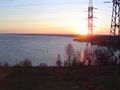
مشهد من نهر الأب قرب محطة توليد الطاقة بنوڤوسيبيرسك
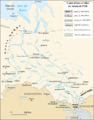
الحوض النهري لنهر أب

صورة جوية لدلتا نهر أب


انظر أيضا
المصادر
- ^ "Ob River at Salekhard". River Discharge Database. Center for Sustainability and the Global Environment. 2010-02-13. Archived from the original on 2010-06-12. Retrieved 2010-11-06.
- ^ https://online.ucpress.edu/elementa/article/9/1/00098/117201/Changing-freshwater-contributions-to-the-ArcticA.
{{cite web}}: Missing or empty|title=(help) - ^ https://online.ucpress.edu/elementa/article/9/1/00098/117201/Changing-freshwater-contributions-to-the-ArcticA.
{{cite web}}: Missing or empty|title=(help) - ^ "Ob River at Salekhard". River Discharge Database. Center for Sustainability and the Global Environment. 2010-02-13. Archived from the original on 2010-06-12. Retrieved 2010-11-06.
- ^ http://www.arctic.noaa.gov/Report-Card/Report-Card-2018/ArtMID/7878/ArticleID/786/Riser-Discharge.
{{cite web}}: Missing or empty|title=(help) - ^ Katz, Hartmut. Zum Flußnamen Ob. — Specimena Sibirica III, pp. 93–95. Wien.
- ^ Rédei, Károly. Szófejtések. — Nyelvtudományi Közlemenyek 93, pp. 125–135.
- ^ أ ب ت ث One or more of the preceding sentences incorporates text from a publication now in the public domain: Chisholm, Hugh, ed. (1911). . دائرة المعارف البريطانية. Vol. 19 (eleventh ed.). Cambridge University Press. p. 944.
{{cite encyclopedia}}: Cite has empty unknown parameter:|coauthors=(help) - ^ Приобское плато Archived 2022-07-02 at the Wayback Machine; Great Soviet Encyclopedia in 30 vols. — Ch. ed. A.M. Prokhorov. – 3rd ed. – M. Soviet Encyclopedia, 1969–1978. (in روسية)
- ^ "Location of Novosibirskaya GES". Google Maps. Archived from the original on 9 September 2022. Retrieved 1 July 2017.
- ^ Rasputin, Valentin (29 October 1997). Siberia, Siberia (in الإنجليزية). Northwestern University Press. p. 36. ISBN 978-0-8101-1575-0.
- ^ أ ب ت Naumov, Igor V. (22 November 2006). The History of Siberia (in الإنجليزية). Routledge. p. 53. ISBN 978-1-134-20703-9.
- ^ Kerner, Robert Joseph (15 November 2023). The Urge to the Sea: The Course of Russian History: The Role of Rivers, Portages, Ostrogs, Monasteries, and Furs (in الإنجليزية). Univ of California Press. p. 72. ISBN 978-0-520-35030-4.
- ^ Douglas R. Weiner, "A Little Corner of Freedom: Russian Nature Protection from Stalin to Gorbachev" Archived 2017-01-09 at the Wayback Machine. University of California Press, 1999. ISBN 0-520-23213-5. p. 415
- ^ Michael H. Glantz, "Creeping Environmental Problems and Sustainable Development in the Aral Sea..." Archived 2017-01-09 at the Wayback Machine. ISBN 0-521-62086-4. p. 174
- ^ "10 самых грязных рек России". Коммерсантъ (in الروسية). 2020-11-02. Retrieved 2023-12-05.
- تحوي هذه المقالة معلومات مترجمة من الطبعة الحادية عشرة لدائرة المعارف البريطانية لسنة 1911 وهي الآن من ضمن الملكية العامة.
وصلات خارجية
| مناطق العالم | |||||||||||||||||||||||||
|---|---|---|---|---|---|---|---|---|---|---|---|---|---|---|---|---|---|---|---|---|---|---|---|---|---|
|
| ||||||||||||||||||||||||
| انظر أيضاً قارات العالم | |||||||||||||||||||||||||
- Pages using gadget WikiMiniAtlas
- CS1 errors: missing title
- CS1 errors: bare URL
- مقالات المعرفة المحتوية على معلومات من دائرة المعارف البريطانية طبعة 1911
- Wikipedia articles incorporating text from the 1911 Encyclopædia Britannica
- Articles with روسية-language sources (ru)
- CS1 الروسية-language sources (ru)
- Short description is different from Wikidata
- Native name template errors
- Coordinates on Wikidata
- Wikipedia articles in need of updating from October 2023
- All Wikipedia articles in need of updating
- مقالات مأخوذة من الطبعة الحادية عشرة لدائرة المعارف البريطانية
- نهر أب
- أنهار كراي ألطاي
- أنهار أكروگ خانتي-مانسي الذاتي
- أنهار أوبلاست نوڤوسيبيرسك
- أنهار أوبلاست تومسك
- أنهار أكروگ يمالو-ننتس الذاتي
- جغرافيا سيبيريا
- أنهار مضفرة في روسيا
- سهل سيبيريا الغربي
- صفحات مع الخرائط