مناطق بلاروس
| Regions and the Special administrative district of Belarus Рэгіёны і Спецыяльны адміністратыўны раён Беларусі (Belarusian) Регионы и Специальный административный район Беларуси (Russian) | |
|---|---|
 | |
| التصنيف | Unitary State |
| الموقع | Republic of Belarus |
| العدد | 7 Regions |
| عدد السكان | (Regions only):1,072,381 (Grodno) – 1,440,718 (Gomel) |
| المساحة | (Regions only):40،361.6 km2 (15،583.72 sq mi) (Grodno) – 25،118.1 km2 (9،698.14 sq mi) (Gomel) |
| الحكومة | Region government |
| التقسيمات | Raion |
 |
|---|
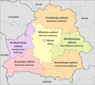
At the top level of administration, Belarus is divided into six regions and the city of Minsk,[1] which has a special status being the capital of Belarus. Minsk is also the capital of Minsk Region.[2]
At the second level, the regions are divided into raions ("districts").
The layout and extent of the regions were set in 1960 when Belarus (then Byelorussian Soviet Socialist Republic) was a part of the Soviet Union.[3]
History
At the start of the 20th century, the boundaries of the Belarusian lands within the Russian Empire were still being defined. Basically in 1900 it contained the entire Minsk Governorate and Mogilev Governorate, the majority of Grodno Governorate, parts of Vitebsk Governorate and the parts of Vilna Governorate (the latter is now in Lithuania).[3] World War I, the independence of Poland, as well as the 1920-1921 Polish–Soviet War affected the boundaries. In 1921, Belarus had what is now all of Minsk Governorate except for the western fringe, the western part of Gomel Region, a western slice of Mahilyow, and a small part of Vitebsk Region. In 1926 the eastern part of Gomel region was added. [3]
In Soviet Belarus, new administrative units, called voblast (cognate of Russian word oblast with prothetic v-) were introduced in 1938. And again, during World War II, the boundaries fluctuated. In 1939 they were reset with Belarus gaining territory to the west, Baranavichy, Belastok (Bialystok), Brest, Pinsk, and Vileyka oblasts. In 1944 Belastok was eliminated and the new oblasts of Babruysk, Grodno, and Polotsk were created. At that same time, Vileika Voblast was renamed Molodechno Voblast.[3]
At different times between 1938 and 1960, the following voblasts existed:
- Babruysk Voblast, created 1944, eliminated 1954
- Baranavichy Voblast, created 1939, eliminated 1954
- Belastok Voblast, created 1939, eliminated 1944 (now Bialystok in Poland)
- Brest Voblast, created 1939
- Gomel Voblast, created 1938
- Grodno Voblast, created 1944
- Maladzyechna Voblast renamed from Vileyka Voblast 1944, eliminated 1960
- Mogilev Voblast, created 1938
- Minsk Voblast, created 1938
- Navahrudak Voblast, created 1939, renamed Baranavichy Voblast December 1939
- Pinsk Voblast, created 1939, eliminated 1954
- Polatsk Voblast, created 1944, eliminated 1954
- Polesia Voblast, created 1938, eliminated 1954
- Vitebsk Voblast, created 1938
- Vileyka Voblast, created 1939, renamed to Maladzyechna Voblast 1944
المناطق
| Flag | Subdivision | Capital | Belarusian | Population (2009 estimate)[4] | Area (km²) | Density | Percentage of Belarus | |
|---|---|---|---|---|---|---|---|---|
| All Belarus | Minsk | Беларусь | 9,503,807 | 207,617.26 | 46.55 | 100.00% | ||
| 1 | Мінск | 1,836,808 | 305.50 | 7144.92 | 18.91% | |||
| 2 | Brest Region | Brest | Брэсцкая | 1,401,177 | 32,790.68 | 43.69 | 14.82% | |
| 3 | Gomel Region | Gomel | Гомельская | 1,440,718 | 40,361.66 | 36.25 | 15.14% | |
| 4 | Grodno Region | Grodno | Гродзенская | 1,072,381 | 25,118.07 | 44.11 | 11.40% | |
| 5 | Mogilev Region | Mogilev | Магілёўская | 1,099,074 | 29,079.01 | 38.73 | 11.61% | |
| 6 | Minsk Region | Minsk | Мінская | 1,422,528 | 39,912.35 | 36.17 | 15.03% | |
| 7 | Vitebsk Region | Vitebsk | Вiцебская | 1,230,821 | 40,049.99 | 31.55 | 13.08% | |
انظر أيضاً
- ISO 3166-2:BY, the ISO codes of the voblasts of Belarus.
- List of regions of Belarus by Human Development Index
المراجع
- ^ Belarus Regions
- ^ Minsk summary, at the website of the Belarus embassy in Russia.
- ^ أ ب ت ث "Regions of Belarus". Statoids.
- ^ Official 2009 census results
وصلات خارجية
- Portal-inline template with redlinked portals
- Pages with empty portal template
- محافظات روسيا البيضاء
- صفحات بها قالب:Ill-WD2 دون وصلات لغات
- Pages using country topics with unknown parameters
- Regions of Belarus
- قوائم تقسيمات بلدان
- تقسيمات البلدان في أوروپا
- تقسيمات ادارية من المستوى الأول لبلد
- Belarus geography-related lists
