مقاطعة پالو پنتو، تكساس
Palo Pinto County | |
|---|---|
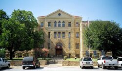
 محكمة مقاطعة پالو پنتو في پالو پنتو. المبنى بالحجر الجيري أضيف إلى السجل الوطني للأماكن التاريخية في 1997. | |
|
Flag | |
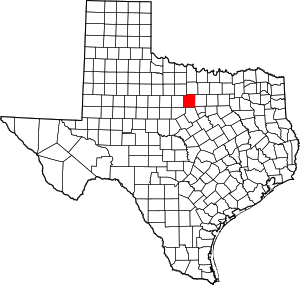
 الموقع ضمن ولاية Texas | |
 موقع Texas ضمن الولايات المتحدة | |
| الإحداثيات: 32°45′N 98°19′W / 32.75°N 98.31°W | |
| البلد | |
| State | |
| تأسست | 1857 |
| السمِيْ | غدير پالو پنتو |
| Largest city | Mineral Wells |
| المساحة | |
| • الإجمالي | 986 ميل² (2٬550 كم²) |
| • البر | 952 ميل² (2٬470 كم²) |
| • الماء | 34 ميل² (90 كم²) 3.4%% |
| التعداد (2010) | |
| • الإجمالي | 28٬111 |
| • الكثافة | 30/sq mi (10/km2) |
| منطقة التوقيت | UTC−6 (Central) |
| • الصيف (التوقيت الصيفي) | UTC−5 (CDT) |
| Congressional district | 11th |
| الموقع الإلكتروني | www |
مقاطعة پالو پنتو إنگليزية: Palo Pinto County هي إحدى المقاطعات في ولاية تكساس، الولايات المتحدة. وفي تعداد 2010 بلغ عدد سكانها 28,111 نسمة.[1] مقر المقاطعة هو پالو پنتو.[2] أنشِئت المقاطعة في 1856 ونـُظـِّمت في العام التالي.[3]
تضم مقاطعة پالو پنتو Mineral Wells, TX Micropolitan Statistical Area, which is part of the Dallas–Fort Worth, TX Combined Statistical Area. It is located in the Western Cross Timbers Ecoregion.
. . . . . . . . . . . . . . . . . . . . . . . . . . . . . . . . . . . . . . . . . . . . . . . . . . . . . . . . . . . . . . . . . . . . . . . . . . . . . . . . . . . . . . . . . . . . . . . . . . . . . . . . . . . . . . . . . . . . . . . . . . . . . . . . . . . . . . . . . . . . . . . . . . . . . . . . . . . . . . . . . . . . . . . .
التاريخ
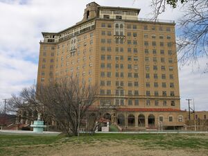
 فندق بيكر المهجور في منرال ولز |
الأمريكان الأصليون
The Brazos Indian Reservation, founded by General Randolph B. Marcy in 1854, provided a safety area from warring Comanche for Delaware, Shawnee, Tonkawa, Wichita, Choctaw, and Caddo. Within the reservation, each tribe had its own village and cultivated agricultural crops. Government-contracted beef cattle were delivered each week. Citizens were unable to distinguish between reservation and nonreservation tribes, blaming Comanche and Kiowa depredations on the reservation Indians. A newspaper in Jacksboro, Texas, titled The White Man advocated removal of all tribes from North Texas.[4][5]
During December 1858, Choctaw Tom, who was a Yowani married to a Hasinai woman, who was at times an interpreter to Sam Houston, and a group of reservation Indians received permission for an off-the-reservation hunt. On December 27, Captain Peter Garland and a vigilante group charged Choctaw Tom's camp, indiscriminately murdering and injuring women and children along with the men. .[6]
التجمعات
المدن
- Gordon
- Graford
- Mineral Wells (partly in Parker County)
- Mingus
- Strawn
مكان مخصص بالإحصاء
- Palo Pinto (مقر المقاطعة)
تجمعات أخرى غير مشهرة
أشخاص بارزون
- Steve Tyrell, singer and recording artist
السياسة
| Year | Republican | Democratic | Third parties |
|---|---|---|---|
| 2016 | 80.7% 8,284 | 16.6% 1,708 | 2.7% 278 |
| 2012 | 79.1% 7,393 | 19.4% 1,811 | 1.6% 147 |
| 2008 | 73.5% 7,264 | 25.3% 2,499 | 1.3% 127 |
| 2004 | 71.3% 7,137 | 28.1% 2,816 | 0.6% 61 |
| 2000 | 62.4% 5,690 | 35.8% 3,263 | 1.8% 165 |
| 1996 | 42.4% 3,666 | 45.5% 3,938 | 12.1% 1,051 |
| 1992 | 30.8% 2,852 | 36.6% 3,392 | 32.7% 3,031 |
| 1988 | 53.9% 4,649 | 45.5% 3,930 | 0.6% 55 |
| 1984 | 62.8% 5,701 | 36.9% 3,349 | 0.3% 27 |
| 1980 | 48.0% 4,068 | 50.0% 4,244 | 2.0% 172 |
| 1976 | 34.0% 2,684 | 65.4% 5,170 | 0.7% 51 |
| 1972 | 69.8% 5,058 | 30.1% 2,181 | 0.1% 8 |
| 1968 | 35.3% 2,627 | 47.8% 3,552 | 16.9% 1,257 |
| 1964 | 31.6% 1,748 | 68.4% 3,791 | 0.0% 2 |
| 1960 | 46.9% 2,695 | 52.6% 3,022 | 0.4% 25 |
| 1956 | 54.2% 2,818 | 45.6% 2,369 | 0.2% 12 |
| 1952 | 51.2% 3,029 | 48.6% 2,876 | 0.2% 12 |
| 1948 | 19.4% 977 | 74.1% 3,736 | 6.6% 332 |
| 1944 | 10.1% 416 | 79.8% 3,291 | 10.2% 419 |
| 1940 | 16.5% 510 | 83.2% 2,571 | 0.3% 9 |
| 1936 | 11.9% 371 | 87.7% 2,738 | 0.5% 14 |
| 1932 | 12.5% 392 | 87.0% 2,722 | 0.5% 14 |
| 1928 | 63.3% 2,001 | 36.7% 1,161 | |
| 1924 | 18.0% 473 | 73.2% 1,926 | 8.8% 232 |
| 1920 | 15.8% 342 | 75.7% 1,645 | 8.5% 185 |
| 1916 | 6.7% 124 | 77.4% 1,431 | 15.9% 293 |
| 1912 | 3.8% 68 | 69.3% 1,231 | 26.9% 478 |
انظر أيضاً
- National Register of Historic Places listings in Palo Pinto County, Texas
- Recorded Texas Historic Landmarks in Palo Pinto County
المراجع
- ^ "State & County QuickFacts". United States Census Bureau. Archived from the original on October 18, 2011. Retrieved December 22, 2013.
- ^ "Find a County". National Association of Counties. Retrieved 2011-06-07.
- ^ "Texas: Individual County Chronologies". Texas Atlas of Historical County Boundaries. The Newberry Library. 2008. Retrieved May 26, 2015.
- ^ Crouch, Carrie J: Brazos Indian Reservation from the Handbook of Texas Online. Retrieved 05 May 2010. Texas State Historical Association.
- ^ Minor, David: White Man from the Handbook of Texas Online. Retrieved 05 May 2010. Texas State Historical Association.
- ^ "Choctaw Tom". Fort Tours. Retrieved 5 May 2010.
- ^ Leip, David. "Dave Leip's Atlas of U.S. Presidential Elections". uselectionatlas.org. Retrieved 8 April 2018.
. . . . . . . . . . . . . . . . . . . . . . . . . . . . . . . . . . . . . . . . . . . . . . . . . . . . . . . . . . . . . . . . . . . . . . . . . . . . . . . . . . . . . . . . . . . . . . . . . . . . . . . . . . . . . . . . . . . . . . . . . . . . . . . . . . . . . . . . . . . . . . . . . . . . . . . . . . . . . . . . . . . . . . . .
وصلات خارجية
- Palo Pinto County government's website
- Historic Palo Pinto County materials hosted by the Portal to Texas History
- Palo Pinto County from the Handbook of Texas Online
32°45′N 98°19′W / 32.75°N 98.31°W{{#coordinates:}}: لا يمكن أن يكون هناك أكثر من وسم أساسي واحد لكل صفحة

|
مقاطعة جاك | مقاطعة ينگ | 
| |
| مقاطعة پاركر | مقاطعة ستيفنز | |||
| مقاطعة هود | مقاطعة إيراث | مقاطعة إيستلاند |
- Pages using gadget WikiMiniAtlas
- صفحات ذات وسوم إحداثيات غير صحيحة
- Short description is different from Wikidata
- Coordinates on Wikidata
- مقاطعات Texas
- Articles containing إنگليزية-language text
- Pages using Lang-xx templates
- Pages with empty portal template
- مقاطعة پالو پنتو، تكساس
- مقاطعات تكساس
- أماكن مأهولة تأسست في 1857
