مقاطعة دلتا، تكساس
Delta County | |
|---|---|
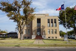
 Delta County Courthouse in Cooper | |
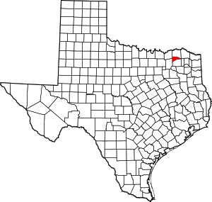
 الموقع ضمن ولاية Texas | |
 موقع Texas ضمن الولايات المتحدة | |
| الإحداثيات: 33°23′N 95°40′W / 33.39°N 95.67°W | |
| البلد | |
| State | |
| تأسست | 1870 |
| Seat | Cooper |
| Largest city | Cooper |
| المساحة | |
| • الإجمالي | 278 ميل² (720 كم²) |
| • البر | 257 ميل² (670 كم²) |
| • الماء | 21 ميل² (50 كم²) 7.6%% |
| التعداد (2016) | |
| • الإجمالي | 5٬215 |
| • الكثافة | 20/sq mi (8/km2) |
| منطقة التوقيت | UTC−6 (Central) |
| • الصيف (التوقيت الصيفي) | UTC−5 (CDT) |
| Congressional district | 4th |
| الموقع الإلكتروني | www |
مقاطعة دلتا إنگليزية: Delta County هي إحدى المقاطعات في ولاية تكساس، الولايات المتحدة الأمريكية.
. . . . . . . . . . . . . . . . . . . . . . . . . . . . . . . . . . . . . . . . . . . . . . . . . . . . . . . . . . . . . . . . . . . . . . . . . . . . . . . . . . . . . . . . . . . . . . . . . . . . . . . . . . . . . . . . . . . . . . . . . . . . . . . . . . . . . . . . . . . . . . . . . . . . . . . . . . . . . . . . . . . . . . . .
Adjacent counties
- Lamar County (north)
- Red River County (east)
- Franklin County (east)
- Hopkins County (south)
- Hunt County (southwest)
- Fannin County (northwest)
Demographics
| التعداد التاريخي | |||
|---|---|---|---|
| التعداد | Pop. | %± | |
| 1880 | 5٬597 | — | |
| 1890 | 9٬117 | 62٫9% | |
| 1900 | 15٬249 | 67٫3% | |
| 1910 | 14٬566 | −4٫5% | |
| 1920 | 15٬887 | 9٫1% | |
| 1930 | 13٬138 | −17٫3% | |
| 1940 | 12٬858 | −2٫1% | |
| 1950 | 8٬964 | −30٫3% | |
| 1960 | 5٬860 | −34٫6% | |
| 1970 | 4٬927 | −15٫9% | |
| 1980 | 4٬839 | −1٫8% | |
| 1990 | 4٬857 | 0٫4% | |
| 2000 | 5٬327 | 9٫7% | |
| 2010 | 5٬231 | −1٫8% | |
| 2016 (تق.) | 5٬215 | [1] | −0٫3% |
| U.S. Decennial Census[2] 1850–2010[3] 2010–2014[4] | |||
Communities
Cities
- Cooper
- Pecan Gap (small part in Fannin County)
- Commerce (majority in Hunt County)
Unincorporated communities
Ghost Town
Multiple County City
Politics
| Year | Republican | Democratic | Third parties |
|---|---|---|---|
| 2016 | 80.5% 1,836 | 17.5% 400 | 2.0% 45 |
| 2012 | 75.5% 1,524 | 22.5% 454 | 2.0% 40 |
| 2008 | 72.3% 1,580 | 26.9% 589 | 0.8% 18 |
| 2004 | 69.5% 1,447 | 30.1% 627 | 0.4% 8 |
| 2000 | 60.2% 1,143 | 38.2% 726 | 1.6% 31 |
| 1996 | 42.7% 744 | 48.7% 849 | 8.6% 150 |
| 1992 | 29.7% 599 | 42.9% 864 | 27.4% 552 |
| 1988 | 40.4% 849 | 59.2% 1,244 | 0.4% 8 |
| 1984 | 51.2% 1,024 | 48.6% 973 | 0.2% 4 |
| 1980 | 35.8% 767 | 62.9% 1,347 | 1.3% 28 |
| 1976 | 21.2% 421 | 78.5% 1,563 | 0.4% 7 |
| 1972 | 61.9% 957 | 37.6% 581 | 0.5% 8 |
| 1968 | 19.7% 370 | 55.1% 1,037 | 25.2% 475 |
| 1964 | 17.3% 339 | 82.6% 1,619 | 0.1% 2 |
| 1960 | 25.1% 460 | 74.2% 1,360 | 0.7% 12 |
| 1956 | 32.2% 605 | 67.2% 1,262 | 0.5% 10 |
| 1952 | 30.8% 707 | 69.1% 1,585 | 0.1% 3 |
| 1948 | 7.7% 146 | 83.9% 1,594 | 8.4% 160 |
| 1944 | 6.7% 133 | 85.9% 1,706 | 7.5% 148 |
| 1940 | 7.9% 190 | 92.1% 2,214 | |
| 1936 | 5.3% 82 | 94.6% 1,466 | 0.1% 1 |
| 1932 | 4.1% 87 | 95.8% 2,013 | 0.1% 1 |
| 1928 | 44.0% 753 | 55.9% 958 | 0.1% 2 |
| 1924 | 17.6% 479 | 80.5% 2,186 | 1.9% 51 |
| 1920 | 21.0% 315 | 72.2% 1,081 | 6.8% 102 |
| 1916 | 5.0% 72 | 86.5% 1,254 | 8.6% 124 |
| 1912 | 7.1% 57 | 87.3% 705 | 5.7% 46 |
. . . . . . . . . . . . . . . . . . . . . . . . . . . . . . . . . . . . . . . . . . . . . . . . . . . . . . . . . . . . . . . . . . . . . . . . . . . . . . . . . . . . . . . . . . . . . . . . . . . . . . . . . . . . . . . . . . . . . . . . . . . . . . . . . . . . . . . . . . . . . . . . . . . . . . . . . . . . . . . . . . . . . . . .
انظر أيضاً
- List of counties in Texas
- Dry counties
- List of museums in North Texas
- Recorded Texas Historic Landmarks in Delta County
References
- ^ "Population and Housing Unit Estimates". Retrieved June 9, 2017.
- ^ "U.S. Decennial Census". United States Census Bureau. Archived from the original on April 26, 2015. Retrieved April 22, 2015.
{{cite web}}: Unknown parameter|deadurl=ignored (|url-status=suggested) (help) - ^ "Texas Almanac: Population History of Counties from 1850–2010" (PDF). Texas Almanac. Retrieved April 22, 2015.
- ^ خطأ استشهاد: وسم
<ref>غير صحيح؛ لا نص تم توفيره للمراجع المسماةQF - ^ Leip, David. "Dave Leip's Atlas of U.S. Presidential Elections". uselectionatlas.org. Retrieved 2018-07-21.
وصلات خارجية
- Delta County website
- Delta County Chamber of Commerce website
- Delta County in Handbook of Texas Online
- Delta County History at HistoricTexas.net
- Jot 'Em Down, Delta County, Texas data at Internet Accuracy Project

|
Red River County | Lamar County | Fannin County | 
|
| Franklin County | ||||
| Hopkins County | Hopkins County | Hunt County |
- CS1 errors: unsupported parameter
- Pages using gadget WikiMiniAtlas
- Short description is different from Wikidata
- مقاطعات Texas
- Articles containing إنگليزية-language text
- Pages using Lang-xx templates
- Pages using US Census population needing update
- Pages with empty portal template
- Coordinates on Wikidata
- Delta County, Texas
- 1870 establishments in Texas
- Populated places established in 1870
- Dallas–Fort Worth metroplex counties
- مقاطعات ولاية تكساس الأمريكية
