كيپ هاتـِراس
كيپ هاتـِراس Cape Hatteras | |
|---|---|
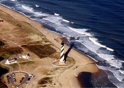
 An aerial view of the Cape Hatteras Lighthouse prior to its 1999 relocation | |
| الإحداثيات: 35°13′21″N 75°31′48″W / 35.22250°N 75.53000°W | |
| الموقع | جزيرة هاتـِراس، مقاطعة دير, كارولينا الشمالية، الولايات المتحدة |
كيپ هاتـِراس (Cape Hatteras ؛ /ˈhætərəs/) هي رأس يقع عند ثنية بارزة في جزيرة هاتـِراس، احدى الجزر الحاجزة في كارولينا الشمالية.
For thousands of years, these barrier islands have survived onslaughts of wind and sea. Long stretches of beach, sand dunes, marshes, and maritime forests create a unique environment where wind and waves shape the topography. A large area of the Outer Banks is part of a National Park, called the Cape Hatteras National Seashore. It is also the nearest landmass on the North American mainland to Bermuda, which is about 563 ميل بحري (648 mi; 1،043 km) to the east-southeast.
The treacherous waters off the coast of the Outer Banks are known as the Graveyard of the Atlantic, Over 600 ships wrecked here as victims of shallow shoals, storms, and war. Diamond Shoals, a bank of shifting sand ridges hidden beneath the turbulent sea off Cape Hatteras, has never promised safe passage for ships. In the past 400 years, the graveyard has claimed many lives, but island villagers saved many. As early as the 1870s, villagers served in the United States Life-Saving Service. Others staffed lighthouses built to guide mariners. Few ships wreck today, but storms still uncover the ruins of the old wrecks that lie along the beaches of the Outer Banks.
Cape Hatteras National Seashore protects parts of three barrier islands: Bodie Island, Hatteras Island, and Ocracoke Island. Beach and sound access ramps, campgrounds, nature trails, and lighthouses can be found and explored on all three islands.[1]
The community of Buxton lies on the inland side of the Cape itself, at the widest part of Hatteras Island. It is the largest community on the island, and is home to the governmental offices and schools for the island.
التاريخ
الجغرافيا
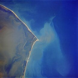
Cape Hatteras lies in the chain of long, thin barrier islands of the Outer Banks, which arch out into the Atlantic Ocean away from the U.S. mainland, then back toward the mainland, creating lagoons and estuaries sheltered from the Atlantic Ocean. It is the site where the two great basins of the East Coast meet.[2] The cape's shoals are known as Diamond Shoals.
المناخ
| بيانات المناخ لـ كيپ هاتـِراس (Billy Mitchell Airport), 1991–2020 normals,[أ] extremes 1898–present[ب] | |||||||||||||
|---|---|---|---|---|---|---|---|---|---|---|---|---|---|
| الشهر | ينا | فب | مار | أبر | ماي | يون | يول | أغس | سبت | أكت | نوف | ديس | السنة |
| القصوى القياسية °ف (°س) | 75 (24) |
76 (24) |
82 (28) |
89 (32) |
91 (33) |
97 (36) |
96 (36) |
94 (34) |
92 (33) |
89 (32) |
81 (27) |
78 (26) |
97 (36) |
| متوسط القصوى اليومية °ف (°س) | 55.4 (13.0) |
56.7 (13.7) |
61.4 (16.3) |
69.4 (20.8) |
76.7 (24.8) |
84.0 (28.9) |
87.3 (30.7) |
87.0 (30.6) |
83.0 (28.3) |
75.0 (23.9) |
66.8 (19.3) |
59.3 (15.2) |
71.8 (22.1) |
| المتوسط اليومي °ف (°س) | 48.0 (8.9) |
49.1 (9.5) |
53.8 (12.1) |
61.8 (16.6) |
69.7 (20.9) |
77.5 (25.3) |
81.3 (27.4) |
80.7 (27.1) |
76.9 (24.9) |
68.2 (20.1) |
58.7 (14.8) |
52.1 (11.2) |
64.8 (18.2) |
| متوسط الدنيا اليومية °ف (°س) | 40.6 (4.8) |
41.5 (5.3) |
46.2 (7.9) |
54.1 (12.3) |
62.7 (17.1) |
70.9 (21.6) |
75.3 (24.1) |
74.4 (23.6) |
70.8 (21.6) |
61.3 (16.3) |
51.5 (10.8) |
44.9 (7.2) |
57.8 (14.3) |
| متوسط الدنيا °ف (°س) | 24.2 (−4.3) |
27.4 (−2.6) |
31.7 (−0.2) |
40.6 (4.8) |
49.2 (9.6) |
59.3 (15.2) |
67.0 (19.4) |
65.3 (18.5) |
59.3 (15.2) |
46.2 (7.9) |
36.6 (2.6) |
30.6 (−0.8) |
22.6 (−5.2) |
| الصغرى القياسية °ف (°س) | 6 (−14) |
11 (−12) |
19 (−7) |
26 (−3) |
39 (4) |
44 (7) |
52 (11) |
56 (13) |
45 (7) |
32 (0) |
22 (−6) |
12 (−11) |
6 (−14) |
| متوسط تساقط الأمطار inches (mm) | 4.91 (125) |
4.34 (110) |
4.43 (113) |
3.92 (100) |
4.37 (111) |
4.41 (112) |
5.39 (137) |
6.73 (171) |
7.63 (194) |
5.59 (142) |
4.76 (121) |
4.73 (120) |
61.21 (1٬555) |
| متوسط هطول الثلج inches (cm) | 0.3 (0.76) |
0.1 (0.25) |
0.0 (0.0) |
0.0 (0.0) |
0.0 (0.0) |
0.0 (0.0) |
0.0 (0.0) |
0.0 (0.0) |
0.0 (0.0) |
0.0 (0.0) |
0.0 (0.0) |
1.3 (3.3) |
1.7 (4.3) |
| Average precipitation days (≥ 0.01 in) | 10.9 | 10.5 | 10.7 | 8.9 | 9.1 | 10.1 | 11.5 | 11.8 | 11.2 | 9.5 | 9.8 | 11.2 | 125.2 |
| متوسط الرطوبة النسبية (%) | 75.3 | 74.3 | 74.1 | 72.3 | 77.3 | 79.0 | 80.9 | 80.6 | 78.5 | 75.8 | 75.1 | 75.1 | 76.5 |
| Mean monthly ساعات سطوع الشمس | 153.7 | 162.8 | 224.8 | 261.3 | 278.3 | 272.4 | 282.9 | 267.1 | 233.0 | 207.2 | 170.8 | 142.8 | 2٬657٫1 |
| نسبة السطوع المحتمل للشمس | 49 | 53 | 61 | 66 | 64 | 63 | 64 | 64 | 63 | 59 | 55 | 47 | 60 |
| Source: NOAA (snowfall 1981–2010, relative humidity and sun 1961–1990)[3][4][5][6] | |||||||||||||
ملاحظات
- ^ Mean monthly maxima and minima (i.e. the expected highest and lowest temperature readings at any point during the year or given month) calculated based on data at said location from 1991 to 2020.
- ^ Official temperature and precipitation records for Cape Hatteras were kept at Hatteras from January 1893 to February 1957, and at Billy Mitchell Airport since March 1957. Snowfall and snow depth records date to 1 January 1908 and 1 January 1948 respectively.[3] For more information, see ThreadEx.
المراجع
- ^ USC 459
- ^ Heavey, Bill (June 5, 1996). "Point Well Taken". The Washington Post. p. C9. ProQuest 307904917.
- ^ أ ب "NOWData - NOAA Online Weather Data". National Oceanic and Atmospheric Administration. Retrieved May 5, 2021.
- ^ "Station Name: NC CAPE HATTERAS AP". National Oceanic and Atmospheric Administration. Retrieved May 6, 2021.
- ^ "Summary of Monthly Normals 1981–2010". National Oceanic and Atmospheric Administration. Retrieved May 6, 2021.
- ^ "WMO Climate Normals for CAPE HATTERAS, NC 1961–1990". National Oceanic and Atmospheric Administration. Retrieved May 27, 2014.
وصلات خارجية
- National Park Service: Cape Hatteras National Seashore
- Graveyard of the Atlantic Museum
- Nautical chart of Cape Hatteras
- (2003) Monthly wind roses for Cape Hatteras, by National Oceanic and Atmospheric Administration
| سبقه بكستن |
شواطئ الآوتر بانكس | تبعه فرسكو |


