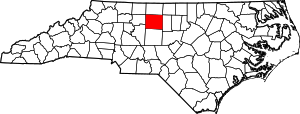
مقاطعة گيلفورد، كارولاينا الشمالية
Guilford County | |
|---|---|
 Old Guilford County Courthouse in Greensboro | |
 الموقع ضمن ولاية North Carolina | |
 موقع North Carolina ضمن الولايات المتحدة | |
| الإحداثيات: 36°05′N 79°46′W / 36.083°N 79.767°W | |
| البلد | |
| State | |
| تأسست | 1771 |
| السمِيْ | Francis North, 1st Earl of Guilford |
| Seat | گرينزبورو (courthouse also located in High Point) |
| Largest city | گرينزبورو |
| المساحة | |
| • الإجمالي | 658 ميل² (1٬700 كم²) |
| • البر | 646 ميل² (1٬670 كم²) |
| • الماء | 12 ميل² (30 كم²) 1.8%% |
| التعداد | |
| • Estimate (2018) | 533٬670 |
| • الكثافة | 792٫7/sq mi (306٫1/km2) |
| منطقة التوقيت | UTC−5 (Eastern) |
| • الصيف (التوقيت الصيفي) | UTC−4 (EDT) |
| Congressional districts | 6th، 13th |
| الموقع الإلكتروني | www |
مقاطعة گيلفورد إنگليزية: Guilford County هي إحدى مقاطعات ولاية كارولاينا الشمالية في الولايات المتحدة الأمريكية. مركز المقاطعة أو مقعدها هي مدينة گرينزبورو. تأسست هذه المقاطعة سنة 1771.أصل هذه المقاطعة يأتي من: مقاطعة أورانج ومقاطعة روان.
. . . . . . . . . . . . . . . . . . . . . . . . . . . . . . . . . . . . . . . . . . . . . . . . . . . . . . . . . . . . . . . . . . . . . . . . . . . . . . . . . . . . . . . . . . . . . . . . . . . . . . . . . . . . . . . . . . . . . . . . . . . . . . . . . . . . . . . . . . . . . . . . . . . . . . . . . . . . . . . . . . . . . . . .
الجغرافيا
المقاطعات المجاورة
- Rockingham County (north)
- Alamance County (east)
- Randolph County (south)
- Davidson County (southwest)
- Forsyth County (west)
الديمغرافيا
| التعداد التاريخي | |||
|---|---|---|---|
| التعداد | Pop. | %± | |
| 1790 | 7٬300 | — | |
| 1800 | 9٬442 | 29٫3% | |
| 1810 | 11٬420 | 20٫9% | |
| 1820 | 14٬511 | 27٫1% | |
| 1830 | 18٬737 | 29٫1% | |
| 1840 | 19٬175 | 2٫3% | |
| 1850 | 19٬754 | 3�0% | |
| 1860 | 20٬056 | 1٫5% | |
| 1870 | 21٬736 | 8٫4% | |
| 1880 | 23٬585 | 8٫5% | |
| 1890 | 28٬052 | 18٫9% | |
| 1900 | 39٬074 | 39٫3% | |
| 1910 | 60٬497 | 54٫8% | |
| 1920 | 79٬272 | 31�0% | |
| 1930 | 133٬010 | 67٫8% | |
| 1940 | 153٬916 | 15٫7% | |
| 1950 | 191٬057 | 24٫1% | |
| 1960 | 246٬520 | 29�0% | |
| 1970 | 288٬590 | 17٫1% | |
| 1980 | 317٬154 | 9٫9% | |
| 1990 | 347٬420 | 9٫5% | |
| 2000 | 421٬048 | 21٫2% | |
| 2010 | 488٬406 | 16�0% | |
| 2018 (تق.) | 533٬670 | [1] | 9٫3% |
| U.S. Decennial Census[2] 1790-1960[3] 1900-1990[4] 1990-2000[5] 2010-2013[6] | |||
القانون والحكم
Guilford County is a member of the regional Piedmont Triad Council of Governments.
| Year | Republican | Democratic | Third parties |
|---|---|---|---|
| 2016 | 38.1% 98,062 | 58.0% 149,248 | 3.9% 10,095 |
| 2012 | 41.3% 104,789 | 57.7% 146,365 | 1.1% 2,698 |
| 2008 | 40.4% 97,718 | 58.8% 142,101 | 0.8% 1,952 |
| 2004 | 49.3% 98,254 | 50.2% 100,042 | 0.5% 1,018 |
| 2000 | 50.8% 84,394 | 48.6% 80,787 | 0.7% 1,083 |
| 1996 | 45.9% 67,727 | 46.9% 69,208 | 7.2% 10,652 |
| 1992 | 41.1% 60,140 | 45.3% 66,319 | 13.6% 19,940 |
| 1988 | 56.4% 66,060 | 43.0% 50,351 | 0.7% 821 |
| 1984 | 61.3% 73,096 | 38.6% 46,027 | 0.2% 213 |
| 1980 | 51.9% 53,291 | 43.4% 44,516 | 4.7% 4,815 |
| 1976 | 49.0% 45,441 | 50.5% 46,826 | 0.5% 473 |
| 1972 | 69.5% 61,381 | 29.2% 25,800 | 1.3% 1,185 |
| 1968 | 46.2% 38,996 | 30.4% 25,604 | 23.4% 19,751 |
| 1964 | 47.1% 35,635 | 52.9% 39,969 | |
| 1960 | 57.6% 41,357 | 42.4% 30,486 | |
| 1956 | 59.9% 32,751 | 40.1% 21,948 | |
| 1952 | 53.4% 33,310 | 46.6% 29,028 | |
| 1948 | 40.1% 14,167 | 48.7% 17,224 | 11.2% 3,958 |
| 1944 | 35.6% 12,962 | 64.5% 23,495 | |
| 1940 | 26.9% 9,770 | 73.1% 26,565 | |
| 1936 | 27.1% 9,514 | 72.9% 25,579 | |
| 1932 | 31.9% 9,263 | 66.4% 19,301 | 1.7% 495 |
| 1928 | 62.6% 16,541 | 37.4% 9,872 | |
| 1924 | 42.8% 6,822 | 55.2% 8,804 | 2.0% 317 |
| 1920 | 45.2% 7,920 | 54.8% 9,615 | |
| 1916 | 44.1% 3,670 | 55.4% 4,616 | 0.5% 44 |
| 1912 | 7.3% 460 | 60.4% 3,830 | 32.3% 2,048 |
انظر أيضاً
- National Register of Historic Places listings in Guilford County, North Carolina
- USS Guilford (APA-112)
المراجع
- ^ "Population and Housing Unit Estimates". Retrieved July 22, 2019.
- ^ "U.S. Decennial Census". United States Census Bureau. Retrieved January 17, 2015.
- ^ "Historical Census Browser". University of Virginia Library. Retrieved January 17, 2015.
- ^ Forstall, Richard L., ed. (March 27, 1995). "Population of Counties by Decennial Census: 1900 to 1990". United States Census Bureau. Retrieved January 17, 2015.
- ^ "Census 2000 PHC-T-4. Ranking Tables for Counties: 1990 and 2000" (PDF). United States Census Bureau. April 2, 2001. Retrieved January 17, 2015.
- ^ خطأ استشهاد: وسم
<ref>غير صحيح؛ لا نص تم توفيره للمراجع المسماةQF - ^ Leip, David. "Dave Leip's Atlas of U.S. Presidential Elections". uselectionatlas.org. Retrieved 2018-03-15.
. . . . . . . . . . . . . . . . . . . . . . . . . . . . . . . . . . . . . . . . . . . . . . . . . . . . . . . . . . . . . . . . . . . . . . . . . . . . . . . . . . . . . . . . . . . . . . . . . . . . . . . . . . . . . . . . . . . . . . . . . . . . . . . . . . . . . . . . . . . . . . . . . . . . . . . . . . . . . . . . . . . . . . . .
وصلات خارجية
- Guilford County government official website
- NCGenWeb Guilford County - free genealogy resources for the county

|
Rockingham County | 
| ||
| Alamance County | Forsyth County | |||
| Randolph County | Davidson County |
- Short description is different from Wikidata
- Pages using gadget WikiMiniAtlas
- مقاطعات North Carolina
- Articles containing إنگليزية-language text
- Pages using Lang-xx templates
- Pages using US Census population needing update
- مقاطعة گيلفورد، كارولاينا الشمالية
- Populated places on the Underground Railroad
- تأسيسات 1771 في الولايات المتحدة
- أماكن مأهولة تأسست في 1771

