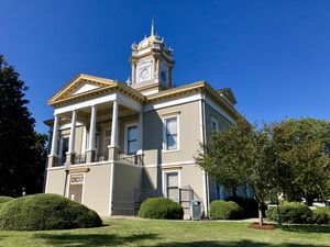
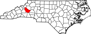
مقاطعة برك، كارولاينا الشمالية
Burke County | |
|---|---|
 | |
| الشعار: "All About Advancing" | |
 الموقع ضمن ولاية North Carolina | |
 موقع North Carolina ضمن الولايات المتحدة | |
| الإحداثيات: خطأ لوا في وحدة:Coordinates على السطر 612: bad argument #1 to 'sub' (string expected, got nil). | |
| البلد | |
| State | |
| تأسست | 1777 |
| السمِيْ | Thomas Burke |
| Seat | Morganton |
| Largest city | Morganton |
| المساحة | |
| • الإجمالي | 514٫24 ميل² (1٬331٫9 كم²) |
| • البر | 506٫24 ميل² (1٬311٫2 كم²) |
| • الماء | 8٫00 ميل² (20٫7 كم²) 1.56% |
| التعداد (2020) | |
| • الإجمالي | 87٬570 |
| • Estimate (2022) | 87٬881 |
| • الكثافة | 172٫98/sq mi (66٫79/km2) |
| منطقة التوقيت | UTC−5 (Eastern) |
| • الصيف (التوقيت الصيفي) | UTC−4 (EDT) |
| Congressional district | 10th |
| الموقع الإلكتروني | www |
مقاطعة برك إنگليزية: Burke County هي إحدى مقاطعات ولاية كارولاينا الشمالية في الولايات المتحدة الأمريكية. مركز المقاطعة أو مقعدها هي مدينة مورغانتون. تأسست هذه المقاطعة سنة 1777.أصل هذه المقاطعة يأتي من: مقاطعة روان.
. . . . . . . . . . . . . . . . . . . . . . . . . . . . . . . . . . . . . . . . . . . . . . . . . . . . . . . . . . . . . . . . . . . . . . . . . . . . . . . . . . . . . . . . . . . . . . . . . . . . . . . . . . . . . . . . . . . . . . . . . . . . . . . . . . . . . . . . . . . . . . . . . . . . . . . . . . . . . . . . . . . . . . . .
National protected areas
- Blue Ridge Parkway (part)
- Linville Falls
- Linville Gorge Wilderness (part)
- Pisgah National Forest (part)
State and local protected areas
- Johns River Game Land[1]
- Lake James State Park (part)
- Pisgah National Forest Game Land (part)[1]
- Pisgah (WRC) Game Land (part)[1]
- South Mountains Game Lands (part)[1]
- South Mountains State Park
Major water bodies
- Canoe Creek
- Catawba River
- Dales Creek
- Drowning Creek
- Hall Creek
- Henry Fork
- Irish Creek
- Jacob Fork
- Lake James
- Lake Rhodhiss
- Linville River
- Little River
- Old Catawba River
- Pearcey Creek
- Rock Creek
- Roses Creek
- Silver Creek
- Upper Creek
Adjacent counties
- Avery County - northwest
- Caldwell County - north
- Catawba County - east
- Cleveland County - south
- Rutherford County - south
- McDowell County - west
الطرق السريعة الرئيسية
- Invalid type: I
- Invalid type: US
- Invalid type: US-Bus
- Invalid type: US
- Invalid type: US-Bus
- Invalid type: US
- Invalid type: US
- Invalid type: NC
- Invalid type: NC
- Invalid type: NC
- Invalid type: NC
- Invalid type: NC
البنية التحتية الرئيسية
- Foothills Regional Airport (partially in Caldwell County)
- Hickory Regional Airport (partially in Catawba County)
السكان
| التعداد التاريخي | |||
|---|---|---|---|
| التعداد | Pop. | %± | |
| 1790 | 8٬106 | — | |
| 1800 | 9٬929 | 22٫5% | |
| 1810 | 11٬007 | 10٫9% | |
| 1820 | 13٬411 | 21٫8% | |
| 1830 | 17٬888 | 33٫4% | |
| 1840 | 15٬799 | −11٫7% | |
| 1850 | 7٬772 | −50٫8% | |
| 1860 | 9٬237 | 18٫8% | |
| 1870 | 9٬777 | 5٫8% | |
| 1880 | 12٬809 | 31�0% | |
| 1890 | 14٬939 | 16٫6% | |
| 1900 | 17٬699 | 18٫5% | |
| 1910 | 21٬408 | 21�0% | |
| 1920 | 23٬297 | 8٫8% | |
| 1930 | 29٬410 | 26٫2% | |
| 1940 | 38٬615 | 31٫3% | |
| 1950 | 45٬518 | 17٫9% | |
| 1960 | 52٬701 | 15٫8% | |
| 1970 | 60٬364 | 14٫5% | |
| 1980 | 72٬504 | 20٫1% | |
| 1990 | 75٬744 | 4٫5% | |
| 2000 | 89٬148 | 17٫7% | |
| 2010 | 90٬912 | 2�0% | |
| 2020 | 87٬570 | −3٫7% | |
| 2022 (تق.) | 87٬881 | [2] | 0٫4% |
| U.S. Decennial Census[3] 1790–1960[4] 1900–1990[5] 1990–2000[6] 2010–2014[7] 2020[8] | |||
2020 census
| Race | Number | Percentage |
|---|---|---|
| White (non-Hispanic) | 68,664 | 78.41% |
| Black or African American (non-Hispanic) | 4,762 | 5.44% |
| Native American | 238 | 0.27% |
| Asian | 3,150 | 3.6% |
| Pacific Islander | 64 | 0.07% |
| Other/Mixed | 3,508 | 4.01% |
| Hispanic or Latino | 7,184 | 8.2% |
As of the 2020 United States census, 87,570 people, 36,634 households, and 25,391 families resided in the county.
Government and politics
Burke County leans heavily Republican in presidential elections. The last Democrat to carry the county was Jimmy Carter in 1976. Lyndon Johnson, who won the county as a Democrat in 1964, was the only other one to do so since World War II. However, as late as the 1990s, Democratic presidential candidates have managed to garner 40% of the county's vote. As was typical for all of the South outside the Appalachian highlands and a few stronghold Republican counties, Burke County was mostly solidly Democratic before WWII.
In the North Carolina Senate, Burke County lies within the 46th Senate district, which also covers Cleveland County and is represented by RepublicanWarren Daniel. In the North Carolina House of Representatives, the northern two-thirds of Burke County comprises the 86th District represented by Republican Hugh Blackwell. The southern third lies within the 112nd district, which also covers Rutherford County and is represented by Republican David Rogers.
Burke County is a member of the regional Western Piedmont Council of Governments. The county is governed by a five-member Board of Commissioners, elected to serve four-year terms.[10]
| السنة | الجمهوري | الديمقراطي | حزب ثالث | |||
|---|---|---|---|---|---|---|
| رقم. | % | رقم. | % | رقم. | % | |
| 2020 | 31,019 | 69٫55% | 13,118 | 29٫41% | 465 | 1٫04% |
| 2016 | 26,238 | 67٫42% | 11,251 | 28٫91% | 1,431 | 3٫68% |
| 2012 | 22,267 | 60٫93% | 13,701 | 37٫49% | 576 | 1٫58% |
| 2008 | 22,102 | 59٫03% | 14,901 | 39٫80% | 440 | 1٫18% |
| 2004 | 18,922 | 61٫51% | 11,728 | 38٫12% | 112 | 0٫36% |
| 2000 | 18,466 | 60٫23% | 11,924 | 38٫89% | 268 | 0٫87% |
| 1996 | 13,853 | 48٫97% | 11,678 | 41٫28% | 2,760 | 9٫76% |
| 1992 | 13,397 | 44٫48% | 12,565 | 41٫71% | 4,160 | 13٫81% |
| 1988 | 15,933 | 59٫41% | 10,848 | 40٫45% | 38 | 0٫14% |
| 1984 | 18,766 | 64٫32% | 10,353 | 35٫48% | 59 | 0٫20% |
| 1980 | 12,956 | 50٫97% | 11,680 | 45٫95% | 781 | 3٫07% |
| 1976 | 10,070 | 41٫22% | 14,254 | 58٫34% | 107 | 0٫44% |
| 1972 | 14,447 | 68٫96% | 6,197 | 29٫58% | 306 | 1٫46% |
| 1968 | 11,068 | 48٫84% | 5,704 | 25٫17% | 5,892 | 26�00% |
| 1964 | 10,081 | 44٫03% | 12,815 | 55٫97% | 0 | 0�00% |
| 1960 | 12,925 | 56٫34% | 10,015 | 43٫66% | 0 | 0�00% |
| 1956 | 11,823 | 59٫65% | 7,999 | 40٫35% | 0 | 0�00% |
| 1952 | 11,113 | 58٫97% | 7,732 | 41٫03% | 0 | 0�00% |
| 1948 | 6,374 | 47٫26% | 6,226 | 46٫16% | 888 | 6٫58% |
| 1944 | 5,855 | 46٫28% | 6,795 | 53٫72% | 0 | 0�00% |
| 1940 | 4,889 | 40٫30% | 7,242 | 59٫70% | 0 | 0�00% |
| 1936 | 5,506 | 42٫48% | 7,454 | 57٫52% | 0 | 0�00% |
| 1932 | 4,823 | 44٫92% | 5,866 | 54٫64% | 47 | 0٫44% |
| 1928 | 5,108 | 63٫94% | 2,881 | 36٫06% | 0 | 0�00% |
| 1924 | 3,190 | 43٫54% | 4,137 | 56٫46% | 0 | 0�00% |
| 1920 | 3,592 | 52٫41% | 3,262 | 47٫59% | 0 | 0�00% |
| 1916 | 1,474 | 47٫63% | 1,621 | 52٫37% | 0 | 0�00% |
| 1912 | 48 | 1٫78% | 1,365 | 50٫54% | 1,288 | 47٫69% |
. . . . . . . . . . . . . . . . . . . . . . . . . . . . . . . . . . . . . . . . . . . . . . . . . . . . . . . . . . . . . . . . . . . . . . . . . . . . . . . . . . . . . . . . . . . . . . . . . . . . . . . . . . . . . . . . . . . . . . . . . . . . . . . . . . . . . . . . . . . . . . . . . . . . . . . . . . . . . . . . . . . . . . . .
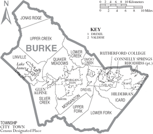
Communities
City
- Morganton (county seat and largest city)
Towns
Townships
- Drexel
- Icard
- Jonas Ridge
- Linville
- Lovelady
- Lower Creek
- Lower Fork
- Quaker Meadows
- Silver Creek
- Smoky Creek
- Upper Creek
- Upper Fork
- Hildebran
- Connelly Springs
- Rutherford College
- Valdese
Census-designated places
Unincorporated communities
- Amherst
- Enola
- Jonas Ridge
- Linville Falls
- Petersburg
- Pleasant Grove
- Sunnyside
في الثقافة الشعبية
Although never explicitly mentioned by name in the novel, the hideout of Robur-the villain in Jules Verne's Master of the World-is thought to be Table Rock Mountain in Burke County.
Many scenes from the 1992 film Last of the Mohicans were filmed in Burke County. A full-scale fort was built next to the Linville boat access on Lake James for the filming. The fort was later destroyed and the land replanted with trees. Many of the extras who played settlers, British soldiers, and Native Americans were locals from Burke and surrounding counties.
The final scene from The Hunt for Red October had the backdrop filmed on Lake James, while the actors stayed in Hollywood.
In 2011, scenes for the Lionsgate adaptation of The Hunger Games were filmed near Hildebran, North Carolina, at the Henry River Mill Village.
See also
- List of counties in North Carolina
- National Register of Historic Places listings in Burke County, North Carolina
- Burke County Regiment of the Salisbury District Brigade
References
- ^ أ ب ت ث "NCWRC Game Lands". www.ncpaws.org. Retrieved 2023-03-30.
- ^ "U.S. Census Bureau QuickFacts: Burke County, North Carolina". www.census.gov. Retrieved May 31, 2022.
- ^ "U.S. Decennial Census". United States Census Bureau. Retrieved January 12, 2015.
- ^ "Historical Census Browser". University of Virginia Library. Retrieved January 12, 2015.
- ^ Forstall, Richard L., ed. (March 27, 1995). "Population of Counties by Decennial Census: 1900 to 1990". United States Census Bureau. Retrieved January 12, 2015.
- ^ "Census 2000 PHC-T-4. Ranking Tables for Counties: 1990 and 2000" (PDF). United States Census Bureau. April 2, 2001. Archived (PDF) from the original on 2010-03-27. Retrieved January 12, 2015.
- ^ "State & County QuickFacts". United States Census Bureau. Archived from the original on June 6, 2011. Retrieved October 17, 2013.
- ^ "U.S. Census Bureau QuickFacts: Burke County, North Carolina". www.census.gov. Retrieved May 31, 2022.
- ^ "Explore Census Data". data.census.gov. Retrieved 2021-12-21.
- ^ "Burke County Board of Commissioners". Archived from the original on July 3, 2017. Retrieved May 30, 2017.
- ^ Leip, David. "Dave Leip's Atlas of U.S. Presidential Elections". uselectionatlas.org. Retrieved March 14, 2018.
External links
![]() Geographic data related to مقاطعة برك، كارولاينا الشمالية at OpenStreetMap
Geographic data related to مقاطعة برك، كارولاينا الشمالية at OpenStreetMap
قالب:Burke County, North Carolina
خطأ لوا في وحدة:Authority_control على السطر 278: attempt to call field '_showMessage' (a nil value). 35°45′N 81°43′W / 35.75°N 81.71°W
- Pages using gadget WikiMiniAtlas
- Short description is different from Wikidata
- مقاطعات North Carolina
- Pages using infobox U.S. county with unknown parameters
- Articles containing إنگليزية-language text
- Pages using Lang-xx templates
- Articles with hatnote templates targeting a nonexistent page
- Jct template errors
- Coordinates on Wikidata
- Burke County, North Carolina
- Counties of Appalachia
- Western North Carolina

