كيموخو
Kummuh Kummaḫa | |||||||||
|---|---|---|---|---|---|---|---|---|---|
| ؟–708 ق.م. | |||||||||
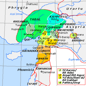
 كيموخو بين الدويلات الحيثية الحديثة | |||||||||
| العاصمة | كيموخو 37°33′N 38°30′E / 37.550°N 38.500°E | ||||||||
| اللغات المشتركة | اللوڤية الهيروغليفية | ||||||||
| الدين | الديانة اللوڤية | ||||||||
| الحكومة | ملكية | ||||||||
| الحقبة التاريخية | العصر الحديدي | ||||||||
• تأسست | ؟ | ||||||||
• انحلت | 708 ق.م. | ||||||||
| |||||||||
| اليوم جزء من | تركيا | ||||||||
كيموخو Kimukhu أو كوموه Kummuh كانت مملكة حثية حديثة من العصر الحديدي تقع على الضفة الغربية لأعالي نهر الفرات داخل الحلقة الشرقية للنهر بين مليد وكركميش. تشير المصادر الآشورية إلى كل من البلد وعاصمتها بنفس الاسم. استقر العلماء على أن المدينة تطابق مدينة سميساط في الفترة الكلاسيكية، والتي أمست سمسات هويوك في العصر الحالي، والتي غمرتها الآن مياه سد بُنيَ حديثًا. تشير المصادر الأورارتية إلى أنه Kummaha.[1] The name is also attested in at least one local royal inscription dating to the 8th century BCE.[2] Other places that are mentioned in historical sources as lying within Kummuh are lands of Kištan and Halpi, and cities of Wita, Halpa, Parala, Sukiti and Sarita(?).[3] جاورت كيموخو ممالك مليد إلى الشمال، Gurgum إلى الغرب و كركميش إلى الجنوب، بينما واجهت من الشرق آشور ولاحقاً أورارتو.
Several indigenous rock inscriptions have been found in the region, all written in Hieroglyphic Luwian, attesting to the continuity of Hittite traditions. وفي حولياته، أشار الملك الآشوري سرگون الثاني إلى ملك كيموخو بالـ 'حيثي'، وحمل العديد من حكام كيموخو نفس الأسماء كالمشاهير من الملوك الحيثيين في الألفية الثانية ق.م.: Hattušili(?), Šuppiluliuma, and Muwattalli (in Assyrian sources Qatazilu, Ušpilulume، و Muttallu, respectively).[4]
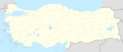
موقع كيموخو في تركيا |
التاريخ
From the Middle Hittite Period (15th century BCE) onwards, the Hittite archives of Hattuša refer to a city of Kummaha,[5] which might be identical to the later city of Kummuh.[6]
Most of the information about Kummuh comes from Assyrian sources. From the beginning of the 9th to the middle of the 8th centuries, Kummuh seems to have remained a peaceful tributary state allied with Assyria. In 866 BCE, Kummuh king Qatazilu paid tribute to Assyrian king Ashurnasirpal II in the city of Huzirina (modern-day Sultantepe). In 858 BCE, Assyrian king Shalmaneser III reported in his Kurkh Monolith that Qatazilu submitted to him peacefully after the Assyrian king crossed the Euphrates on a campaign to the west. A similar report is mentioned for another campaign in 857. In 853 BCE, a new king in Kummuh, Kundašpi, was reported by Shalmaneser III as being among the northern Syrian kings who submitted to him in the city of Pitru.[7]
In 805 BCE, as reported on the Pazarcık Stele, the Kummuh king Ušpilulume (Šuppiluliuma) asked for the assistance of the Assyrian king Adad-nirari III against the a coalition of eight kings led by Ataršumki of Arpad. Adad-nirari apparently travelled with his mother Šammuramat, defeated the alliance, and established the border between Kummuh and Gurgum at Pazarcık. In 773 BCE, the same boundary was re-established by Assyrian general (turtanu) Šamši-ilu acting on behalf of Assyrian king Shalmaneser IV. Around 750 BCE Kummuh was attacked by the Urartian king Sarduri II who captured the cities of Wita and Halpi, and made the Kummuh king Kuštašpi pay a tribute. In 743, BCE Kuštašpi was among the Urartu-Arpad alliance against Tiglath-pileser III of Assyria. The alliance was defeated but Tiglath-pieleser III pardoned Kuštašpi along with the kings of Melid and Gurgum. Kuštašpi appears as a tributary of Tiglath-pileser III in 738 and 732.
In 712 BCE, after the Kingdom of Melid was dismembered by the Assyrian king Sargon II, the city of Melid itself was given to Kummuh king Muttallu.
In 708 BCE, Sargon II accused Muttallu of allying himself with Urartu and sent his army into Kummuh. According to the annals, Muttallu escaped but the royal family and the population was deported to Babylonia, and settlers from Bit-Yakin (in Babylonia) were brought to Kummuh. Thereafter the region became a province of Assyria and was under the jurisdiction of the turtanu of the left, whose seat of power was apparently the city of Kummuh.
After the Assyrian empire collapsed, a city of the name of Kimuhu, which is almost certainly Kummuh, appears in a conflict between Egyptians and Babylonians in 607–606 BCE. The Babylonian king Nabopolassar captured the city and stationed a garrison there, whereupon the Egyptian army under the command of Necho II laid siege to it and captured it after a four-month siege.[8]
Kummuh later gave its name to the classical Commagene.
ملوك كيموخو
| الملك | المعاصر الآشوري |
|---|---|
| Qatazilu (Hattušili?) | Assurnasirpal II (884-859 BCE) Shalmaneser III (859-824 BCE) |
| Kundašpi | Shalmaneser III (859-824 BCE) |
| Ušpilulume (Šuppiluliuma) | Adad-nirari III (811-783 BCE) Shalmaneser IV (783-773 BCE) |
| Hattušili?[9] | ? Ashur-Dan III (773-755 BCE) ? Ashur-nirari V (755-745 BCE) |
| Kuštašpi | ? Ashur-nirari V (755-745 BCE) Tiglat-pileser III (745-727 BCE) |
| Mutallu (Muwattalli) | Sargon II (722-705 BCE) |
نقوش
Several monuments with Hieroglyphic Luwian inscriptions dating to the kingdom of Kummuh have been found in the region, as at Samsat, Ancoz, Boybeypınarı, Malpınarı and Adıyaman. The one found in Boybeypınarı is the longest and best preserved of them. It is made of several basalt blocks and dates to the reign of Šuppiluliuma. The Malpınarı inscription is carved on a natural rock cliff and dates to the reign of Hattušili, son of Šuppiluliuma.[10] An improved reading of ANCOZ 5 mentions the pair "Hattušili and Šuppiluliuma, father and son" (as opposed to a father Šuppiluliuma and son Hattušili), which may suggest the existence of either a second Šuppiluliuma or second Hattušili.[9]
الهامش
- ^ Kummuhi as it appears in Assyrian sources should not be confused with Katmuhi which is a separate settlement on the bank of Tigris. Hawkins, J. D. (2000) Corpus of Hieroglyphic Luwian Inscriptions, v1, part 1, p. 330.
- ^ See Malpınarı Rock Inscription
- ^ Hawkins, Corpus, p. 331.
- ^ Hawkins, J. D. (1983) Reallexicon der Assyriologie 6, p. 338.
- ^ Otten, H. (1983) Reallexicon der Assyriologie 6, p. 334.
- ^ Hittite Kummaha may also be identified with the modern-day Kemah, which is located further to the north, outside of the region of Kummuh; see Garstang, J. and Gurney, O. R. (1959) Geography of the Hittite Empire, p. 35.
- ^ Also mentioned in Kurkh Monolith
- ^ ABC 4: Chronicle Concerning the Late Years of Nabopolassar
- ^ أ ب Existence of a Hattušili is based on Malpınarı inscription as well as several of the Ancoz inscriptions which indicate a certain Hattušili, son of Šuppiluliuma. If Šuppiluliuma is the same person as Ušpilulume of the Assyrian sources, his son Hattušili must have ruled before Kuštašpi. Another possibility would be matching Hattušili with Qatazilu of the 9th century, which would suggest the existence of another Šuppiluliuma preceding Qatazilu, see Hawkins, Corpus, p.330.
Another inscription, ANCOZ 5, mentions the pair "Hattušili and Šuppiluliuma, father and son" which suggests the existence of either a second Šuppiluliuma or second Hattušili, requiring a dynastic order of either Šuppiluliuma-Hattušili-Šuppiluliuma or Hattušili-Šuppiluliuma-Hattušili, see Poetto, M. (2010) "L'iscrizione luvio-geroglifica ANCOZ 5 (A) rivista e completata" , Hethitica XVI (Gs Neu), 131-142.
- ^ See Hawkins, Corpus, p.330-360, for a treatment of most of the inscriptions.

