كوتونو
كوتونو
Cotonou | |
|---|---|
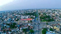 صورة جوية لكوتونو في يناير 2017 | |
| الإحداثيات: 6°22′N 2°26′E / 6.367°N 2.433°E | |
| البلد | |
| Department | Littoral Department |
| الحكومة | |
| • العمدة | Nicéphore Soglo (2008–2015) |
| المساحة | |
| • الإجمالي | 79 كم² (31 ميل²) |
| المنسوب | 51 m (167 ft) |
| التعداد (2013)[1] | |
| • الإجمالي | 679٬012 |
| • الكثافة | 8٬600/km2 (22٬000/sq mi) |
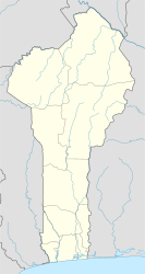
كوتونو (Cotonou ؛ النطق الفرنسي: [kɔtɔnu]؛ فون: Kútɔ̀nú)[2] هي أكبر مدينة والمركز الاقتصادي لـبنين. بلغ التعداد الرسمي للمدينة 761,137 نسمة في 2006؛ إلا أن بعض التقديرات تبلغ 1.2 مليون نسمة. التعداد في 1960 كان مجرد 70,000 نسمة. وتواصل المنطقة الحضرية التوسع، خصوصاً باتجاه الغرب. تقع المدينة في جنوب شرق البلد، بين المحيط الأطلسي و بحيرة نوكويه.[3]
بالإضافة لكونها أكبر مدن بنين، فإنها مقر الحكومة، بالرغم من أن پورتو-نوڤو هي العاصمة الرسمية. وهي مقر معظم المباني الحكومية والبعثات الدبلوماسية.
التاريخ
الاسم "كوتونو" يعني "على نهر الموت" بلغة الفون. في مطلع القرن 19، كانت كوتونو (وكانت تُكتب آنذاك "Kutonou") قرية صيادين صغيرة. بالرغم من أنها كانت تابعة لمملكة داهومي، ففي 1851 الجمهورية الفرنسية الثانية أبرمت معاهدة مع الملك Ghezo سمحت لهم بتأسيس نقطة تبادل تجاري في كوتونو. وفي عهد الملك Glele (1858–89)، الأراضي كان قد تم التنازل عنها لصالح الامبراطورية الفرنسية الثانية عبر معاهدة وُقِعت في 1878.[4]في 1883، احتلت البحرية الفرنسية المدينة لمنع البريطانيين من احتلال المنطقة. بعد وفاة گليلى في 1889، حاول الملك بيهانزين، دون جدوى، التملص من المعاهدة. ولذلك سرعان ما تطورت البلدة لتصبح أكبر ميناء في المنطقة.
الجغرافيا

تقع كوتونو على الشريط الساحلي بين بحيرة نوكويه والمحيط الأطلسي. المدينة قسمها قناة، هي لاگون كوتونو، الذي حفره الفرنسيون في 1855. توجد ثلاثة جسور في تلك المنطقة. ينساب نهر أويميه إلى المحيط الأطلسي عند كوتونو.
أنشأت المدينة بنية تحتية تضم النقل الجوي والبحري والنهري (إلى پورتو نوڤو)، وطرق برية تسهل التجارة مع جاراتها نيجيريا والنيجر وبوركينا فاسو و توگو.
المناخ
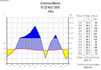
Under Köppen's climate classification, Cotonou features a tropical wet and dry climate, alternating with two rainy seasons (April–July and September–October, 800 to 1,200 mm (47 in) of rain per year) and two dry seasons. In December and January, the city is affected by harmattan winds. Temperatures are relatively constant throughout the year, with the average high temperatures hovering around 30 °C (86 °F), and average low temperatures at around 25 °C (77 °F).
| أخفClimate data for كوتونو (1961–1990, extremes 1910–الحاضر) | |||||||||||||
|---|---|---|---|---|---|---|---|---|---|---|---|---|---|
| Month | Jan | Feb | Mar | Apr | May | Jun | Jul | Aug | Sep | Oct | Nov | Dec | Year |
| Record high °C (°F) | 36.1 (97.0) |
38.6 (101.5) |
36.0 (96.8) |
35.4 (95.7) |
39.0 (102.2) |
33.0 (91.4) |
33.5 (92.3) |
31.8 (89.2) |
31.6 (88.9) |
33.4 (92.1) |
35.4 (95.7) |
36.6 (97.9) |
39.0 (102.2) |
| Mean daily maximum °C (°F) | 30.8 (87.4) |
31.6 (88.9) |
31.9 (89.4) |
31.6 (88.9) |
31.0 (87.8) |
29.2 (84.6) |
28.0 (82.4) |
27.8 (82.0) |
28.4 (83.1) |
29.6 (85.3) |
30.9 (87.6) |
30.8 (87.4) |
30.1 (86.2) |
| Daily mean °C (°F) | 27.3 (81.1) |
28.5 (83.3) |
28.9 (84.0) |
28.6 (83.5) |
27.8 (82.0) |
26.5 (79.7) |
25.8 (78.4) |
25.6 (78.1) |
26.0 (78.8) |
26.7 (80.1) |
27.6 (81.7) |
27.3 (81.1) |
27.2 (81.0) |
| Mean daily minimum °C (°F) | 23.8 (74.8) |
25.4 (77.7) |
25.9 (78.6) |
25.6 (78.1) |
24.6 (76.3) |
23.7 (74.7) |
23.7 (74.7) |
23.4 (74.1) |
23.6 (74.5) |
23.8 (74.8) |
24.3 (75.7) |
23.8 (74.8) |
24.3 (75.7) |
| Record low °C (°F) | 17.0 (62.6) |
17.9 (64.2) |
18.5 (65.3) |
20.7 (69.3) |
19.6 (67.3) |
20.0 (68.0) |
18.8 (65.8) |
19.8 (67.6) |
20.0 (68.0) |
19.1 (66.4) |
21.0 (69.8) |
17.9 (64.2) |
17.0 (62.6) |
| Average precipitation mm (inches) | 9.2 (0.36) |
36.8 (1.45) |
73.8 (2.91) |
137.0 (5.39) |
196.9 (7.75) |
356.0 (14.02) |
147.0 (5.79) |
64.9 (2.56) |
99.0 (3.90) |
126.7 (4.99) |
41.4 (1.63) |
19.6 (0.77) |
1٬308٫3 (51.51) |
| Average precipitation days (≥ 1.0 mm) | 1 | 2 | 4 | 7 | 11 | 15 | 8 | 5 | 8 | 8 | 4 | 2 | 75 |
| Average relative humidity (%) | 82 | 82 | 80 | 82 | 83 | 87 | 86 | 86 | 86 | 86 | 85 | 83 | 84 |
| Mean monthly sunshine hours | 213.9 | 210.0 | 223.2 | 219.0 | 213.9 | 141.0 | 136.4 | 148.8 | 165.0 | 207.7 | 243.0 | 223.2 | 2٬345٫1 |
| Mean daily sunshine hours | 6.9 | 7.5 | 7.2 | 7.3 | 6.9 | 4.7 | 4.4 | 4.8 | 5.5 | 6.7 | 8.1 | 7.2 | 6.4 |
| Source 1: NOAA[5] | |||||||||||||
| Source 2: Deutscher Wetterdienst (humidity, 1951–1967),[6] Meteo Climat (record highs and lows)[7] | |||||||||||||
الديمغرافيا
- 1979: 320,348 (census count)
- 1992: 536,827 (census count)
- 2002: 665,100 (census count)
- 2013: 679,012 (census count)
French is the official language of Benin. Other languages spoken in Cotonou include Fon, Mina, Aja and Yoruba.
المواصلات
الاقتصاد
Important manufactured goods include palm oil, brewing, textiles, and cement.[8] Motor vehicles and bicycles are assembled, and there are sawmills in the city. Petroleum products, bauxite, and iron are major exports. There are offshore platforms drilling for oil. The city is a center for the automotive trade, with European brands being sold from vast open-air parking lots. In the past, Citroën assembled cars (for instance, the Citroën 2CV and Ami 8) locally.[9]
By 2012, piracy in the Gulf of Guinea had significantly decreased trade at the port of Cotonou.[10]
In the Missebo area, Cotonou is a textile market of African print mainly handled by Indian wholesalers and retailers.
أماكن العبادة
التعليم
المدينة تضم حرماً لـجامعة بنين للعلوم والتكنولوجيا (Université des sciences et technologies du Bénin) وحرماً للجامعة الأفريقية للتكنولوجيا والادارة (Université africaine de technologie et de management).
المدن الشقيقة والبلدات التوأم
| البلد | المدينة | الولاية / المنطقة | منذ |
|---|---|---|---|
| 1995 | |||
| 1987 | |||
| 1967 |
انظر أيضاً
- Timeline of Cotonou
- اتفاقية كوتونو Cotonou Agreement
- List of deep water ports
- Railway stations in Benin
- موسيقى بنين
المراجع
- ^ "Benin: Departments, Major Cities & Towns". CityPopulation.de. Retrieved 29 May 2019.
- ^ Spelt Kotonu في
 Chisholm, Hugh, ed. (1911). . دائرة المعارف البريطانية. Vol. 1 (eleventh ed.). Cambridge University Press. p. 67.
 {{cite encyclopedia}}: Cite has empty unknown parameter:|coauthors=(help) - ^ GNS: Country Files Archived مايو 4, 2012 at the Wayback Machine. Earth-info.nga.mil. Retrieved on 2011-06-15.
- ^ Mathurin C. Houngnikpo, Samuel Decalo, Historical Dictionary of Benin, Rowman & Littlefield, USA, 2013, p. 117
- ^ "Cotonou, Benin Climate Normals 1961-1990". National Oceanic and Atmospheric Administration. Retrieved December 19, 2018.
- ^
"Klimatafel von Cotonou, Prov. Atlantique (Süd) / Benin" (PDF). Baseline climate means (1961-1990) from stations all over the world (in German). Deutscher Wetterdienst. Retrieved 11 June 2016.
{{cite web}}: CS1 maint: unrecognized language (link) - ^
"Station Cotonou" (in French). Meteo Climat. Retrieved 11 June 2016.
{{cite web}}: CS1 maint: unrecognized language (link) - ^ Britannica, Cotonou, britannica.com, USA, accessed on July 7, 2019
- ^ World Cars 1972. Automobile Club of Italy/Herald Books, New York: 1972. p. 403, ISBN 0-910714-04-5
- ^ Associated Press (2012-02-27). "UN says piracy off Africa's west coast is increasing, becoming more violent". The Washington Post. Retrieved 2012-02-29.
وصلات خارجية
- Pages using gadget WikiMiniAtlas
- مقالات المعرفة المحتوية على معلومات من دائرة المعارف البريطانية طبعة 1911
- Short description is different from Wikidata
- Coordinates on Wikidata
- Articles containing فون-language text
- Pages using Lang-xx templates
- Pages with empty portal template
- كوتونو
- Communes of Benin
- أماكن مأهولة في بنين
- Port cities in Africa
- غرب أفريقيا الفرنسي
