ضلع أناند
ضلع أناند
Anand district | |
|---|---|
Clockwise from top-left: Borsad Stepwell, Jamia Masjid in Khambhat, Kshemkalyani Mata Temple in Sojitra, GCET college, Amul factory in Anand | |
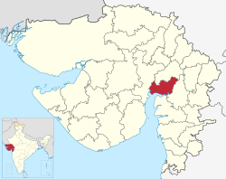
 Location of district in Gujarat | |
| الإحداثيات: {{WikidataCoord}} – malformed coordinate data | |
| البلد | |
| الولاية | گجرات |
| Headquarters | أناند |
| المساحة | |
| • الإجمالي | 3٬204 كم² (1٬237 ميل²) |
| التعداد (2011) | |
| • الإجمالي | 2٬092٬745 |
| • الترتيب | 14th in state |
| • الكثافة | 650/km2 (1٬700/sq mi) |
| اللغات | |
| • الرسمية | Gujarati, هندي |
| منطقة التوقيت | UTC+5:30 (IST) |
| لوحة السيارة | GJ-23[1] |
| الموقع الإلكتروني | https://ananddp.gujarat.gov.in/Anand |
ضلع أناند هو ضلع إداري في ولاية گجرات في غرب الهند and whose popular nickname is Charotar.[3] It was carved out of the Kheda district in 1997. Anand is the administrative headquarters of the district. It is bounded by Kheda District to the north, Vadodara District to the east, Ahmedabad District to the west, and the Gulf of Khambhat to the south. Major towns are Umreth, كهمبات, Karamsad, Tarapur, Petlad, Borsad and Sojitra.
السكان
| Year | Pop. | ±% p.a. |
|---|---|---|
| 1901 | 512٬296 | — |
| 1911 | 502٬049 | −0.20% |
| 1921 | 509٬946 | +0.16% |
| 1931 | 554٬746 | +0.85% |
| 1941 | 659٬996 | +1.75% |
| 1951 | 796٬376 | +1.90% |
| 1961 | 958٬629 | +1.87% |
| 1971 | 1٬173٬757 | +2.05% |
| 1981 | 1٬448٬666 | +2.13% |
| 1991 | 1٬642٬615 | +1.26% |
| 2001 | 1٬856٬872 | +1.23% |
| 2011 | 2٬092٬745 | +1.20% |
| source:[4] | ||
According to the 2011 census, Anand district has a population of 2,092,745 (With total Males 1,088,253 and total Females 1,002,023),[5] roughly equal to the nation of North Macedonia[6] or the US state of New Mexico.[7] This gives it a ranking of 219th in India (out of a total of 640).[5] The district has a population density of 711 inhabitants per square kilometre (1,840/sq mi).[5] Its population growth rate over the decade 2001-2011 was 12.57%.[5] Anand has a sex ratio of 921 females for every 1000 males,[5] and a literacy rate of 85.79% (Males 93.23% and females 77.76%).[8] 30.34% of the population lived in urban areas. Scheduled Castes and Scheduled Tribes made up 4.99% and 1.19% of the population respectively.[5]
At the time of the 2011 Census of India, 96.66% of the population in the district spoke Gujarati, 2.10% Hindi and 0.58% Urdu as their first language.[10]
الطلوقات
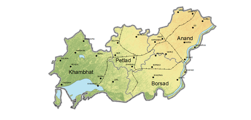
Anand District is administratively divided into eight talukas or subdistricts: أناند، Anklav, Borsad, كهمبات، Petlad, Sojitra, Tarapur, and Umreth.[11]
السياسة
| الضلع | الرقم | الدائرة | الاسم | الحزب | تعليقات | |
|---|---|---|---|---|---|---|
| أناند | 108 | كهمبات | Chirag Patel | Indian National Congress | Resigned on 19 December 2023[12] | |
| Bharatiya Janata Party | Elected on 04 June 2024 | |||||
| 109 | Borsad | Ramanbhai Solanki | Bharatiya Janata Party | |||
| 110 | Anklav | Amit Chavda | Indian National Congress | CLP Leader | ||
| 111 | Umreth | Govindbhai Parmar | Bharatiya Janata Party | |||
| 112 | أناند | Yogesh Patel | Bharatiya Janata Party | |||
| 113 | Petlad | Kamlesh Patel | Bharatiya Janata Party | |||
| 114 | Sojitra | Vipul Patel | Bharatiya Janata Party | |||
معالم
- مدينة أناند - مسقط رأس Tribhuvandas Patel، مؤسس Anand Milk Union Limited and Cooperative movement, Milk City.[13]
- Amul - Origin of Operation Flood, the White Revolution of India
- National Dairy Development Board - Headquarters
- Institute of Rural Management Anand
- جامعة أناند الزراعية[14]
- جامعة سردار پاتل- Located in Vallabh Vidyanagar in Anand District.
- Karamsad - Native place of Sardar Patel.
- كهمبهات - A historic and ancient port in the bay of Khambhat, known for its trade with foreign countries.
- Bhadran - was given nickname "Paris of Gaekwad state" due to its prosperity and civil works carried by Maharaja Sayajirao Gaekwad III about one century ago.
- Umreth - مدينة تراث الجاينية
- Vadtal
انظر أيضاً
المراجع
- ^ "RTO Gujarat Codes". Archived from the original on 2016-05-21. Retrieved 2016-05-28.
- ^ "Anand Pin Code". MapsofIndia.com. Retrieved 2016-05-28.
- ^ "History of Anand District". Gujarat Government. Archived from the original on 10 February 2015. Retrieved 9 October 2012.
- ^ Decadal Variation In Population Since 1901
- ^ أ ب ت ث ج ح "District Census Hand Book – Anand" (PDF). Census of India. Registrar General and Census Commissioner of India.
- ^ US Directorate of Intelligence. "Country Comparison:Population". Archived from the original on June 13, 2007. Retrieved 2011-10-01.
Macedonia 2,077,328 July 2011 est.
- ^ "2010 Resident Population Data". U. S. Census Bureau. Archived from the original on 2013-10-19. Retrieved 2011-09-30.
New Mexico - 2,059,179
- ^ "Anand District Panchayat". ananddp.gujarat.gov.in. 2016. Retrieved 2016-05-28.
- ^ "C-16 Population By Religion - Gujarat". census.gov.in. Office of the Registrar General & Census Commissioner, India.
- ^ أ ب "Table C-16 Population by Mother Tongue: Gujarat". censusindia.gov.in. Registrar General and Census Commissioner of India.
- ^ "Gujarat Administrative Divisions 2011" (PDF). Office of The Registrar General & Census Commissioner, Ministry of Home Affairs, Government of India. Archived (PDF) from the original on 26 October 2011.
- ^ "Khambhat Congress MLA Chirag Patel resigns". DeshGujarat (in الإنجليزية الأمريكية). 2023-12-19. Retrieved 2023-12-19.
- ^ "Anand City". Archived from the original on 2008-09-13. Retrieved 2008-12-07.
- ^ "Welcome to Anand Agricultural University | Anand Agricultural University, Anand". Archived from the original on 2019-08-27. Retrieved 2009-08-25.
وصلات خارجية
| ضلع أناند
]].- Official website

 Geographic data related to ضلع أناند at OpenStreetMap
خطأ لوا في وحدة:Authority_control على السطر 278: attempt to call field '_showMessage' (a nil value).
- CS1 الإنجليزية الأمريكية-language sources (en-us)
- Short description is different from Wikidata
- Pages using Sister project links with wikidata mismatch
- Pages using Sister project links with hidden wikidata
- Portal-inline template with redlinked portals
- Pages with empty portal template
- ضلع أناند
- أماكن مأهولة تأسست في 1997
- أضلع گجرات
- تأسيسات 1997 في گجرات
- صفحات مع الخرائط


