زيگن-ڤيتگنشتاين
| ||||||||||||||||||||||||||||||||||||||||||||||||||||||||||
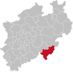
زيگن-ڤيتگنشتاين Siegen-Wittgenstein هي Kreis (district) in the southeast of North Rhine-Westphalia, Germany. Neighboring districts are Olpe, Hochsauerlandkreis, Waldeck-Frankenberg, Marburg-Biedenkopf, Lahn-Dill, Westerwaldkreis, and Altenkirchen.
. . . . . . . . . . . . . . . . . . . . . . . . . . . . . . . . . . . . . . . . . . . . . . . . . . . . . . . . . . . . . . . . . . . . . . . . . . . . . . . . . . . . . . . . . . . . . . . . . . . . . . . . . . . . . . . . . . . . . . . . . . . . . . . . . . . . . . . . . . . . . . . . . . . . . . . . . . . . . . . . . . . . . . . .
التاريخ
In 1816–1817, the two districts of Siegen and Wittgenstein were created as parts of the Prussian province of Westphalia. In 1974, the two districts were merged, and in 1984 the name Siegen-Wittgenstein was adopted.
الجغرافيا
جغرافياً، تغطي زيگن-ڤيتگنشتاين الربى جنوب شرق ربى زاورلاند، و زيگرلاند و ڤيتگنشتاينر لاند.
الدرع
The two upper sections show, to the right, the arms of the Dukes of Nassau, who founded Siegen, and to the left, those of the Counts of Sayn-Wittgenstein. At the bottom a miner's lamp and a coppicing hook are depicted, in reference to the mining and charcoal-burning history of the district.
البلدات والبلديات
الهامش
وصلات خارجية
 Media related to Kreis Siegen-Wittgenstein at Wikimedia Commons
- Official webpage (بالألمانية)
- History and genealogy for Wittgenstein
50°55′N 8°10′E / 50.92°N 8.17°E
خطأ لوا في وحدة:Authority_control على السطر 278: attempt to call field '_showMessage' (a nil value).
- Pages using gadget WikiMiniAtlas
- Short description is different from Wikidata
- Germany articles requiring maintenance
- Pages using infobox settlement with no coordinates
- Pages using infobox German district with unknown parameters
- Districts of Germany
- Articles containing ألمانية-language text
- Pages using infobox country with unknown parameters
- Pages using infobox country or infobox former country with the symbol caption or type parameters
- Coordinates on Wikidata
- 1357 disestablishments in Europe
- دول وأقاليم تأسست في 1174
- Districts of North Rhine-Westphalia
- Siegen-Wittgenstein
- Siegerland
- Counties of the Holy Roman Empire


