زلزال پاكستان 2013
27°00′00″N 65°30′50″E / 27.000°N 65.514°E
 | |
| الوقت UTC | ?? |
|---|---|
| المقدار | 7.7 Mw |
| العمق | 15.0 km (9.3 mi) |
| المركز | 27°00′00″N 65°30′50″E / 27.000°N 65.514°E |
| المناطق المتأثرة | |
| توابع الزلزال | 10 |
| الخسائر | 356 قتيل[1] 619 جريح[2] |
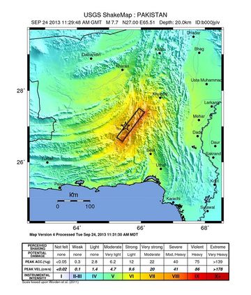
زلزال پاكستان 2013، هو زلزال بقوة Mw 7.7 كان مركزه على بعد 66 كم شمال-شمال شرق أواران، بلوچستان.[3] تسبب الزلزال في مقتل 356 شخص وجرح مئات آخرين.[1]
. . . . . . . . . . . . . . . . . . . . . . . . . . . . . . . . . . . . . . . . . . . . . . . . . . . . . . . . . . . . . . . . . . . . . . . . . . . . . . . . . . . . . . . . . . . . . . . . . . . . . . . . . . . . . . . . . . . . . . . . . . . . . . . . . . . . . . . . . . . . . . . . . . . . . . . . . . . . . . . . . . . . . . . .
التفاصيل السيزمية
الملخص التكتوني
الآثار والضحايا
جزيرة زلزلة
كان الزلزال قوياً بما يكفي لظهور جزيرة صغيرة، سميت فيما بعد جزيرة زلزلة، في البحر العربي، على بعد من 350 متر إلى 1 كم من سواحل گوادر.[4][5][6] تتكون الجزيرة من صخور صلبة، لكن معظمها من الطين والرمال. تأخذ الجزيرة شكل بيضاوي ارتفاعها 18م، وطولها 30م وعرضها 76م حسب فرقة من البحرية الپاكستانية قامت بزيارة الجزيرة بعد يوم من ظهورها.[7]
يعتقد أن الجزيرة نشأت بسبب بركان طيني. في المنطقة، بالرغم من الهيدرات الغازية المتجمدة- والتي تحتوي على كميات كبيرة من الميثان - والتي تتواجد على عمق300-800م من الرواسب المضغوطة.[8] بعد مثل هذا الزلزال القوي، تتحول الهيدرات الغازية من الحالة المتجمدة إلى الغازية بسبب حرارة الاحتكاك وتدفع الرواسب عن طريق الشقوق المتكونة بسبب الزلزال. وهناك عامل آخر قد يكون سبباً في تكون الجزيرة وهو تمييع قاع البحر، والملئ بالرواسب السائلة والمضغوطة والتي يمكنها التدفق من خلال الشقوق لتدفع الرواسب إلى التراكم وتكوين الجزيرة.
بعد نصف ساعة تقريباً من تعرض بلدة گوادر على الساحل الجنوبية لپاكستان للزلزال، حتى بدأت جزيرة زلزال في الظهور. وترتفع الجزيرة بيضاوية الشكل بمقدار من 60-70 قدم فوق سطح الماء. وسطحها غير مستوي وأغلبه موحل، وتعلو بعض أجزائه أتربة ناعمة وأخرى خشنة، بينما كان أحد أجزاء تلك الجزيرة صخرياً. سطح الجزيرة ملئ بالأسماك النافقة، ويسمع على سطحها بوضوح أصوات الغازات المنبعثة من أحد جوانبها.[9]
وهي رابع جزيرة تظهر في المنطقة منذ عام 1945، وهي الثالثة خلال وهي الثالثة خلال الخمسة عشر عاما الأخيرة. وظهرت جزر في عام 1999 وعام 2010 على بعد كيلو متر واحد من ساحل أورمارا، قريبا من دلتا نهر الهانغول.
التوابع
- زلزال Mw 5.9 عن 27°17′42″N 65°39′47″E / 27.295°N 65.663°E حدث في الساعة 11:36:31 UTC (16:36:31 PKT) يوم 24 سبتمبر على عمق 24.5 km (15.2 mi).[10]
- Mw 4.7 earthquake at 27°17′49″N 65°38′49″E / 27.297°N 65.647°E حدث في الساعة 12:07:06 UTC (17:07:06 PKT) يوم 24 سبتمبرع لى عمق 10.1 km (6.3 mi).[11] According to Pakistan's National Seismic Monitoring Centre, this aftershock occurred at 17:07:01 PKT (12:07:01 UTC) عند 24°31′N 69°41′E / 24.51°N 69.69°Eبقوة 5.7 على عمق 110 كم.[12]
- زلزال Mw 5.0 على عمق 27°18′36″N 65°35′38″E / 27.310°N 65.594°E وقع الساعة 12:42:12 UTC (17:42:12 PKT) يوم 24 سبتمبر على عمق 25.7 km (16.0 mi).[13] حسب المركز الوطني لمراقبة النشاط الزلزالي، وقع هذا التابع في الساعة 17:42:16 PKT (12:42:16 UTC) عند 27°18′N 65°48′E / 27.30°N 65.80°E بقوة 5.2 على عمق 26 كم.[12]
- زلزال بقوة Mw 5.6ع ند 27°20′35″N 65°38′31″E / 27.343°N 65.642°E وقع في الساعة 13:01:40 UTC (18:01:40 PKT) يوم 24 سبتمبر على عمق 27.7 km (17.2 mi).[14]
- زلزال بقوة Mw 5.2 عند 27°34′05″N 65°42′25″E / 27.568°N 65.707°E وقع الساعة 14:08:34 UTC (19:08:34 PKT) يوم 24 سبتمبر على عمق 27.1 km (16.8 mi).[15]
- زلزال بقوة Mw 4.9 عند 27°08′38″N 65°30′22″E / 27.144°N 65.506°E وقع الساعة 18:12:24 UTC (23:12:24 PKT) يوم 24 سبتمبر على عمق 27.8 km (17.3 mi).[16]
- زلزال بقوة Mw 5.5 عند 27°11′35″N 65°29′13″E / 27.193°N 65.487°E وقع الساعة 20:20:15 UTC (01:20:15 PKT) يوم 24 سبتمبر على عمق 23.6 km (14.7 mi).[17]
- زلزال بقوة Mw 4.7 عند 27°26′38″N 65°41′56″E / 27.444°N 65.699°E وقع الساعة 22:54:07 UTC (03:54:07 PKT) يوم 24 سبتمبر على عمق 25.7 km (16.0 mi).[18]
- زلزال بقوة Mw 4.9 عند 27°29′42″N 65°45′18″E / 27.495°N 65.755°E وقع الساعة 00:59:04 UTC (05:59:04 PKT) يوم 25 سبتمبر على عمق 24.0 km (14.9 mi).[19]
- زلزال بقوة Mw 4.8 في 27°17′38″N 65°36′40″E / 27.294°N 65.611°E وقع الساعة 01:38:17 UTC (06:38:17 PKT) يوم 25 سبتمبر على عمق 23.0 km (14.3 mi).[20]
. . . . . . . . . . . . . . . . . . . . . . . . . . . . . . . . . . . . . . . . . . . . . . . . . . . . . . . . . . . . . . . . . . . . . . . . . . . . . . . . . . . . . . . . . . . . . . . . . . . . . . . . . . . . . . . . . . . . . . . . . . . . . . . . . . . . . . . . . . . . . . . . . . . . . . . . . . . . . . . . . . . . . . . .
انظر أيضاً
وصلات خارجية
- USGS – Information regarding this earthquake from the United States Geological Survey.
- Pakistan quake island off Gwadar 'emits flammable gas' – Images, video, and some description of the possible cause of Zalzala Jazeera.
- The world's freshest real estate: Massive Pakistani earthquake heaves a brand new 18 meter high island above the waves – Images & video of Zalzala Jazeera. Article also explores some scientific explanations regarding the creation of Zalzala Jazeera.
المصادر
- ^ أ ب "At least 208 killed in Balochistan earthquake". Dawn. 25 September 2013. Retrieved 25 September 2013.
{{cite web}}: Italic or bold markup not allowed in:|publisher=(help) - ^ "Pakistan quake death toll rises to 350". 26 September 2013. Retrieved 26 September 2013.
- ^
 This article incorporates public domain material from the المسح الجيولوجي الأمريكي document "M7.7 - 63km NNE of Awaran, Pakistan".
- ^ "Deadly earthquake strikes Pakistan's Balochistan". BBC News. Retrieved 24 September 2013.
- ^ "Pakistan quake island off Gwadar 'emits flammable gas'". BBC News. 25 September 2013.
- ^ "Island discovered as a result of earthquake in Pakistan". IBNLive.in.com. Press Trust of India. Retrieved 24 September 2013.
- ^ Zolfagharifard, Ellie. "The world's freshest real estate: Massive Pakistani earthquake heaves a brand new 18 meter high island above the waves". The Daily Mail. Retrieved 26 September 2013.
- ^ Khan, Ilyas. "Pakistan quake island off Gwadar 'emits flammable gas'". BBC News. Retrieved 26 September 2013.
- ^ "مولد جزيرة جديدة قبالة ساحل باكستان بعد زلزال بلوشستان". بي بي سي. 2013-09-26. Retrieved 2013-09-27.
- ^ "M5.9 – 102km NNE of Awaran, Pakistan". United States Geological Survey. 24 September 2013. Retrieved 24 September 2013.
{{cite web}}: Italic or bold markup not allowed in:|publisher=(help) - ^ "M4.7 – 101km NNE of Awaran, Pakistan". United States Geological Survey. 24 September 2013. Retrieved 24 September 2013.
{{cite web}}: Italic or bold markup not allowed in:|publisher=(help) - ^ أ ب خطأ استشهاد: وسم
<ref>غير صحيح؛ لا نص تم توفيره للمراجع المسماةPakistanNSMC - ^ "M5.0 – 101km NNE of Awaran, Pakistan". United States Geological Survey. 24 September 2013. Retrieved 24 September 2013.
{{cite web}}: Italic or bold markup not allowed in:|publisher=(help) - ^ "M5.6 – 100km WSW of Khuzdar, Pakistan". United States Geological Survey. 24 September 2013. Retrieved 24 September 2013.
{{cite web}}: Italic or bold markup not allowed in:|publisher=(help) - ^ "M5.2 – 94km WSW of Khuzdar, Pakistan". United States Geological Survey. 24 September 2013. Retrieved 24 September 2013.
{{cite web}}: Italic or bold markup not allowed in:|publisher=(help) - ^ "M4.9 – 81km NNE of Awaran, Pakistan". United States Geological Survey. 24 September 2013. Retrieved 24 September 2013.
{{cite web}}: Italic or bold markup not allowed in:|publisher=(help) - ^ "M5.5 – 85km NNE of Awaran, Pakistan". United States Geological Survey. 24 September 2013. Retrieved 24 September 2013.
{{cite web}}: Italic or bold markup not allowed in:|publisher=(help) - ^ "M4.7 – 98km WSW of Khuzdar, Pakistan". United States Geological Survey. 24 September 2013. Retrieved 24 September 2013.
{{cite web}}: Italic or bold markup not allowed in:|publisher=(help) - ^ "M4.9 – 91km WSW of Khuzdar, Pakistan". United States Geological Survey. 25 September 2013. Retrieved 25 September 2013.
{{cite web}}: Italic or bold markup not allowed in:|publisher=(help) - ^ "M4.8 – 100km NNE of Awaran, Pakistan". United States Geological Survey. 25 September 2013. Retrieved 25 September 2013.
{{cite web}}: Italic or bold markup not allowed in:|publisher=(help)
- Pages using gadget WikiMiniAtlas
- CS1 errors: markup
- مقالات معرفية تضم نصوصاً من المسح الجيولوجي الأمريكي
- Coordinates on Wikidata
- EQ articles needing UTC timestamp
- EQ articles using 'aftershock'
- EQ articles waiting for ISC event id
- EQ articles needing ANSS url
- EQ articles needing 'local-date'
- EQ articles needing 'local-time'
- Pages using infobox earthquake with unknown parameters
- زلازل 2013
- 2013 في پاكستان
- زلازل في پاكستان
- تاريخ بلوچستان


