گودى، الإقليم الصومالي
گودي
Gode | |
|---|---|
مدينة | |
 | |
| الإحداثيات: 5°57′10″N 43°33′06″E / 5.952655°N 43.551579°E | |
| البلد | |
| الإقليم | |
| المقاطعة | شبيلي |
| التعداد (2016) | |
| • الإجمالي | 1٬100٬100 |
| منطقة التوقيت | UTC+3 (EAT) |
| postal code | 3040 |
| مفتاح الهاتف | +251 |
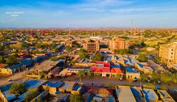
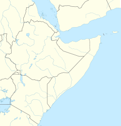
گودي/جودي (Gode ؛ صومالية: Godey، أمهرية: ጎዴ) هي مدينة في قليم صومالي في إثيوپيا. تقع في مقاطعة شبيلي، المدينة كانت عاصمة إقليم صومالي حتى عام 1995 حين أصبحت جيجيگا العاصمة.
مطار گودي، المعروف أيضاً بإسم "مطار أوگاس ميراد" (كود IATA: GDE)، تخدمه رحلات منتظمة تشغلها الخطوط الجوية الإثيوبية. وفي 1968، بنيَ جسر على نهر شبيلي بالقرب من گودي.
التاريخ

During the 1960s, in spite of the threat of tropical water diseases, the Ethiopian government launched the Webi Shabelle Valley Irrigation Programme which was based in Gode . However, attacks by the Western Somali Liberation Front (WSLF) on French hydrologists resulted in the programme being scrapped.[1]
Before the start of the Ogaden War, Gode was garrisoned by the 5th brigade of the 4th division of the Ethiopian Army, distributed around the town in five military camps.[1] Gode's capture near the end of July 1977 by the Western Somali Liberation Front allowed the Somali forces to consolidate their hold on the Ogaden forces and concentrate on an advance that culminated in the capture of Jijiga.[2] According to the historical notes of the Somali Army, Gode was liberated on July 24, 1977 by the regular Somali Army under the leadership of then General Abdullahi Ahmed Irro and his deputy Major Abdulkadir Koosaar.[3][4]
Despite the end of the Ogaden War, the WSLF retained full control of the Gode region long after the Somali Army had systematically withdrawn from the Ogaden in March 1978. Ethiopian units under Brigadier-General Demisse Bulto, commander of the First Revolutionary Army, recaptured Gode during Operation Lash on November 1980. Ethiopian troops used the city as one of its three bases to successfully clear the rest of eastern Ethiopia of Somali guerrillas by 3 December.[5]
Gode has been at the center of several recent famines: one in 1981; the next in 1991, which required the UN High Commission for Refugees to airlift food to 80,000 people stranded outside the town; and most recently in 2000, which caused Gode to swell to a reported size of 100,000 inhabitants. This led John Graham to grimly remark in the Addis Observer, "The main claims to fame of Gode are not inspiring - they are famine and war."[1]
In 1989, the Ethiopian government inaugurated the Malka Wakana Power Plant which was built by a Czechoslovakian firm. The rise of plantations in the nearby Webi Shabelle valley also resulted in the town’s growth as sedentary farmers from other parts of Ethiopia settled within the town.[1]
On 26 July 1994, the then-current mayor, Muktar Aden, Gedden was murdered. For several weeks afterward, it was not clear who was responsible, as no individual or group had taken responsibility or had been accused.[6]
السكان
According to the 1997 national census, the city's total population was 45,755, of whom 26,081 were males and 19,674 were females. The ethnic breakdown was 99%. Gode is primarily inhabited by the Somalis (98.3%), and other ethnic groups make up 1.7% of the population. Based on the 1997 National census, 11,044 inhabitants, or 24.1% of the population, were in school, of whom 2,766 were males and 1,563 were female. On the other hand, 35,478 people, or 77.5% of the overall population, were illiterate, of whom 17,273 were male and 18,205 female.[7]
Based on 2010 figures from the Central Statistical Agency, Gode has an estimated total population of 950,782, of whom 488,235 were males and 442,089 were females.[8] Gode is the largest town in the Gode woreda.
المناخ
Gode has a hot arid climate (Köppen BWh) with uniformly very hot weather and scanty, extremely variable rainfall. The average annual temperature in Gode is 28.8 °C or 83.8 °F, and virtually every afternoon exceeds 32 °C or 89.6 °F, while mornings seldom fall below 20 °C or 68 °F.
There are two short wet seasons in April–May and October–November which provide 291 millimetres or 11.46 inches of precipitation – about ninety percent of the mean annual rainfall of 325 millimetres or 12.80 inches. These wet seasons are caused by brief passages of the Intertropical Convergence Zone over the region; however, they are extremely erratic even for an arid region.[9] The wettest calendar year between 1967 and 1999 was 1967 with 754.2 millimetres (29.69 in) of precipitation and the driest 1980 with 38.8 millimetres (1.53 in) of precipitation.[10]
| أظهرClimate data for گودي، منسوب 295 متر، (1971–2000) |
|---|
ملاحظات
- ^ أ ب ت ث "Local History in Ethiopia" Archived مايو 28, 2008 at the Wayback Machine The Nordic Africa Institute website (accessed 21 November 2007)
- ^ I.M. Lewis, A Modern History of the Somali, fourth edition (Oxford: James Currey, 2002), p. 233
- ^ The Ogaden War (in Somali) http://www.mudugonline.com/Qoraalo/dagaalkii_ogaadeenya/d_o_casharkii45.htm Archived 2011-09-30 at the Wayback Machine
- ^ Brothers-In-Arms "Archived copy" (PDF). Archived from the original (PDF) on 2012-05-03. Retrieved 2012-02-28.
{{cite web}}: CS1 maint: archived copy as title (link) - ^ Gebru Tareke, "From Lash to Red Star: The Pitfalls of Counter-Insurgency in Ethiopia, 1980-82", Journal of Modern African Studies Archived 2016-03-05 at the Wayback Machine, 40 (2002), p. 471
- ^ Gode and Kalafo zones Region 5 (Somali) Archived 2019-12-29 at the Wayback Machine, UNDP Emergencies Unit for Ethiopia report, dated 15 August 1994 (accessed 20 December 2008)
- ^ The 1994 Population and Housing Census of Ethiopia: Results for Somali Region, vol.1 Archived نوفمبر 19, 2008 at the Wayback Machine, Tables 2.3, 2.14, 3.4 and 3.7. The 1994 Ethiopian National Census was delayed in the Somali Region until September 1997.
- ^ CSA 2005 National Statistics Archived نوفمبر 23, 2006 at the Wayback Machine, Table B.4
- ^ Dewar, Robert E. and Wallis, James R; ‘Geographical patterning in interannual rainfall variability in the tropics and near tropics: An L-moments approach’; in Journal of Climate, 12; pp. 3457–3466
- ^ KNMI Climate Explorer; Time series plots per year (Jul-Jun) GODE GHCN v2 precipitation (all) Archived 2023-08-19 at the Wayback Machine
- ^ "CLIMWAT climatic database". Food and Agriculture Organization of United Nations. Retrieved 23 June 2024.
- ^ "Monthly weather forecast and climate in Gode, Ethiopia". Weather Atlas. Archived from the original on 20 January 2022. Retrieved 10 January 2022.

