بليم
بليم
Belém | |
|---|---|
| Município de Belém بلدية بليم | |
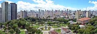
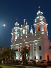
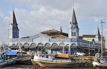
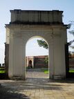
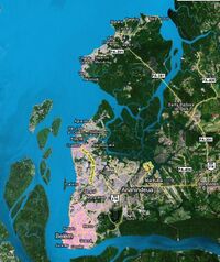
من أعلى لأسفل ومن اليسار إلى اليمين: منظر بانورامي للمنطقة المركزية؛ كاتدرائية سيدة النعم؛ Ver-o-Peso Market؛ مسرح السلام؛ portico of the Forte do Presépio؛ منظر المدينة من خليج گواجارا. | |
| الكنية: "مدينة أشجار المانجو"، "حاضرة الأمازون". | |
| الشعار: Os Estados do Norte estão conosco e nos seguem (الولايات الشمالية معنا وتتبعنا) | |
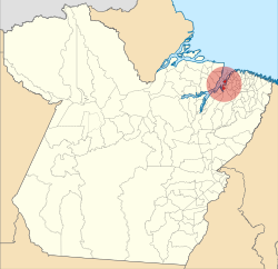 موقع بليم في ولاية پارا | |
| الإحداثيات: 1°27′21″S 48°30′14″W / 1.45583°S 48.50389°W | |
| البلد | |
| المنطقة | الشمالية |
| الولاية | |
| تأسست | 12 يناير 1616 |
| الحكومة | |
| • العمدة | Edmilson Rodrigues (PSOL) |
| • نائب العمدة | Edilson Moura (PT) |
| المساحة | |
| • مدينة | 1٬059٫40 كم² (409٫04 ميل²) |
| المنسوب | 10 m (30 ft) |
| التعداد | |
| • مدينة | 1٬499٬641 |
| • الكثافة | 1٬322/km2 (3٬420/sq mi) |
| • العمرانية | 2٬249٬405 |
| منطقة التوقيت | UTC−3 (BRT) |
| Postal code | 66000-001 to 66999-999 |
| Area code | +55 91 |
| HDI | 0.746 (UN) |
| الموقع الإلكتروني | www |
بـِليم ( Belém ؛ [beˈlẽj];[2] Portuguese for Bethlehem; كانت تسمى في البداية Nossa Senhora de Belém do Grão Pará، بالعربية سيدة بليم في پارا)[3] وكثيراً ما تُدعى Belém of Pará,[4] هي عاصمة ولاية پرا في البرازيل وأهم ميناء في منطقة الأمازون. تقع بيليم على نهر پرا، ويبلغ عدد سكانها 1,203,151 نسمة. ويبلغ عدد سكان حاضرتها الكبرى 1,418,061 نسمة.
أقيمت المدينة عام 1616 بوصفها قاعدة عسكرية لـمملكة البرتغال، فكانت أول مستعمرة أوروبية على الأمازون ولكنها لم تصبح جزءاً من البرازيل حتى 1775. الجزء الأحدث من المدينة يتميز بالمباني الحديثة وناطحات السحات. الجزء الاستعماري يحتفظ برونق الميادين المليئة بالأشجار والكنائس والبلاط الأزرق التقليدي. وللمدينة تاريخ ثري وعمارة من الأزمنة الاستعمارية. ومؤخراً شهدت المدينة عدداً ملحوظاً من ناطحات السحاب.
كما تُعرف بليم بأنها حاضرة منطقة الأمازون البرازيلية أو Cidade das Mangueiras (مدينة أشجار المانجو) بسبب الأعداد الكبيرة من تلك الأشجار في المدينة. وكثيراً ما يشير البرازيليون إلى المدينة بإسم Belém do Pará ("بليم پارا") بدلاً من مجرد بليم، وهي اشارة الاسم المبكر للمدينة، Santa Maria de Belém do Grão Pará، وكذلك لتمييزها عن عدد من البلدات الأخرى بنفس الاسم في البرازيل، كذلك مدينة بيت لحم في فلسطين. وهي مسماة على اسم سانتا ماريا دي بليم في لشبونة، التي تشتهر بالاسم الأقصر، بليم.
بليم يخدمها مطار ڤال دي كانز الدولي، الذي يربط المدينة بباقي البرازيل ومدن أخرى في أمريكا الجنوبية وأمريكا الشمالية (الولايات المتحدة) وأوروپا (لشبونة). المدينة هي مقر جامعة پارا الاتحادية و جامعة ولاية پارا.
أصل الاسم
The name of Belém has origin in بالعبرية: בית לחם, lit. "Bread house". Initially the city was called "St. Mary of Belém of Pará" (برتغالية: Santa Maria de Belém do Pará) or "Our Lady of Belém of Grão-Pará" (برتغالية: Nossa Senhora de Belém do Grão Pará),[5][6] eventually shortened to Belém do Pará (name given by Philip III of Spain),[7] in reference to christmas; the day when captain Francisco Caldeira Castelo Branco left from the city of São Luís in 1615 to conquer the lands of Pará.[6][8][9]
التاريخ
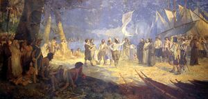
في 1615، قاد القبطان العام البرتغالي فرانسسكو كالديرا برانكو من قبطانية باهيا تجريدة عسكرية أسلها الحاكم العام للبرازيل لضبط الرحلات التجارية للأجانب (الفرنسيين والهولنديين والإنگليز) لأعلى نهر الأمازون من كابو دو نورتى في گراو پارا.
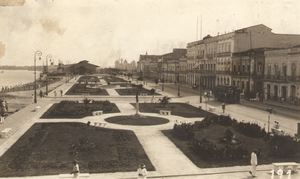
وفي 12 يناير 1616، رسا في ما يُعرف الآن بإسم خليج گواجارا، المتشكل من التقاء نهري پارا و گواما، الذي كان Tupinambás يسمونه "Guaçu Paraná". Caldeira mistook the bay for the main channel, and thirty leagues (178 كم) upstream, he built a wooden fort, covered with straw, which he called "Presépio" (nativity scene), now known as "Forte do Castelo". المستعمرة المتشكلة من الحصن سُميت Feliz Lusitânia, "لوزيتانيا السعيدة". وقد كانت جنين مدينة بليم المستقبلية. فشل الحصن في القضاء على تجارة الهولنديين والفرنسيين، ولكنه نجح في منع الاستعمار.
الجغرافيا
The municipality includes the islands of Mosqueiro, fringed by 14 freshwater beaches, and Caratateua which receive a large number of visitors in summertime. In addition to these وأيضاً بالقرب من بليم, هي جزيرة تاتوكا التي هي موقع واحدة كم سبع محطات جيوفيزيائية في العالم، والمحطة الوحيدة في أمريكا اللاتينية.
المناخ
تتسم بليم بـ tropical rainforest climate (Köppen: Af)[10][11] more subject to the Intertropical Convergence Zone than the maritime trade winds, and with no cyclones, that is a true equatorial climate. In all 12 months of the year, the city on average sees more than 60 mm of rainfall, so the city has no true dry season month. However, Belém features noticeably wetter and drier seasons. The wetter season spans from December through May, while the drier season covers the remaining six months of the year. Like many cities with a tropical rainforest climate, average temperatures vary little throughout the course of the year, generally hovering around 26.5 degrees Celsius. As one would expect, tropical rainforest is the natural vegetation in and around the city.[بحاجة لمصدر]
| Climate data for بليم (Curió-Utinga), elevation: 10 m or 33 ft, 1981–2010 normals and extremes | |||||||||||||
|---|---|---|---|---|---|---|---|---|---|---|---|---|---|
| Month | Jan | Feb | Mar | Apr | May | Jun | Jul | Aug | Sep | Oct | Nov | Dec | Year |
| Record high °C (°F) | 34.7 (94.5) |
34.6 (94.3) |
37.3 (99.1) |
34.9 (94.8) |
34.9 (94.8) |
34.7 (94.5) |
34.5 (94.1) |
36.7 (98.1) |
35.3 (95.5) |
35.4 (95.7) |
36.4 (97.5) |
37.3 (99.1) |
37.3 (99.1) |
| Mean daily maximum °C (°F) | 31.1 (88.0) |
30.8 (87.4) |
30.7 (87.3) |
31.1 (88.0) |
31.7 (89.1) |
31.9 (89.4) |
32.0 (89.6) |
32.5 (90.5) |
32.6 (90.7) |
32.6 (90.7) |
32.7 (90.9) |
32.2 (90.0) |
31.8 (89.3) |
| Daily mean °C (°F) | 26.1 (79.0) |
25.8 (78.4) |
26.0 (78.8) |
26.2 (79.2) |
26.5 (79.7) |
26.5 (79.7) |
26.3 (79.3) |
26.7 (80.1) |
26.8 (80.2) |
26.9 (80.4) |
27.1 (80.8) |
26.7 (80.1) |
26.5 (79.6) |
| Mean daily minimum °C (°F) | 22.7 (72.9) |
22.8 (73.0) |
23.0 (73.4) |
23.2 (73.8) |
23.1 (73.6) |
22.8 (73.0) |
22.5 (72.5) |
22.5 (72.5) |
22.4 (72.3) |
22.4 (72.3) |
22.7 (72.9) |
22.8 (73.0) |
22.7 (72.9) |
| Record low °C (°F) | 19.4 (66.9) |
18.8 (65.8) |
19.8 (67.6) |
19.2 (66.6) |
19.8 (67.6) |
19.8 (67.6) |
14.0 (57.2) |
18.5 (65.3) |
18.8 (65.8) |
18.9 (66.0) |
18.6 (65.5) |
19.0 (66.2) |
14.0 (57.2) |
| Average precipitation mm (inches) | 384.5 (15.14) |
399.5 (15.73) |
450.3 (17.73) |
424.3 (16.70) |
298.4 (11.75) |
185.3 (7.30) |
153.8 (6.06) |
134.8 (5.31) |
128.2 (5.05) |
129.2 (5.09) |
127.4 (5.02) |
268.3 (10.56) |
3٬084 (121.44) |
| Average precipitation days (≥ 1 mm) | 24 | 24 | 25 | 25 | 23 | 16 | 15 | 12 | 13 | 13 | 13 | 19 | 222 |
| Average relative humidity (%) | 88.3 | 89.9 | 89.8 | 89.8 | 87.1 | 83.7 | 82.5 | 81.4 | 80.8 | 80.1 | 80.7 | 84.2 | 84.9 |
| Mean monthly sunshine hours | 130.3 | 103.1 | 111.1 | 132.8 | 186.7 | 228.7 | 250.8 | 266.4 | 242.4 | 231.8 | 191.7 | 159.1 | 2٬234٫9 |
| Source: INMET[12][13][14][15][16][17][18][19][20] | |||||||||||||
| Climate data for Belém (São Brás), elevation: 10 m or 33 ft, 1961-1990 normals | |||||||||||||
|---|---|---|---|---|---|---|---|---|---|---|---|---|---|
| Month | Jan | Feb | Mar | Apr | May | Jun | Jul | Aug | Sep | Oct | Nov | Dec | Year |
| Mean daily maximum °C (°F) | 30.9 (87.6) |
30.5 (86.9) |
30.4 (86.7) |
30.8 (87.4) |
31.3 (88.3) |
31.7 (89.1) |
31.7 (89.1) |
32.1 (89.8) |
32.1 (89.8) |
32.2 (90.0) |
32.3 (90.1) |
31.9 (89.4) |
31.5 (88.7) |
| Daily mean °C (°F) | 26.6 (79.9) |
24.5 (76.1) |
25.5 (77.9) |
26.7 (80.1) |
25.9 (78.6) |
25.9 (78.6) |
25.8 (78.4) |
26.0 (78.8) |
26.1 (79.0) |
26.4 (79.5) |
26.4 (79.5) |
26.1 (79.0) |
26.0 (78.8) |
| Mean daily minimum °C (°F) | 22.1 (71.8) |
22.2 (72.0) |
22.4 (72.3) |
21.8 (71.2) |
22.6 (72.7) |
22.1 (71.8) |
21.7 (71.1) |
21.7 (71.1) |
21.7 (71.1) |
21.6 (70.9) |
21.9 (71.4) |
22.0 (71.6) |
22.0 (71.6) |
| Average precipitation mm (inches) | 366.5 (14.43) |
417.5 (16.44) |
436.2 (17.17) |
360.0 (14.17) |
304.4 (11.98) |
140.2 (5.52) |
152.1 (5.99) |
131.1 (5.16) |
140.8 (5.54) |
116.1 (4.57) |
111.8 (4.40) |
216.4 (8.52) |
2٬893٫1 (113.89) |
| Average relative humidity (%) | 86.0 | 91.0 | 91.0 | 91.0 | 88.0 | 86.0 | 85.0 | 84.0 | 84.0 | 83.0 | 83.0 | 86.0 | 86.5 |
| Mean monthly sunshine hours | 135.5 | 99.0 | 103.7 | 121.8 | 186.9 | 225.4 | 252.8 | 255.8 | 228.3 | 228.3 | 203.3 | 179.0 | 2٬219٫8 |
| Source: NOAA[21] | |||||||||||||
الكساء النباتي
الاقتصاد
Many valuable products now exported from the Amazon by way of Belém are aluminium, iron ore, and other metals,[22] nuts (chiefly Brazil nuts), pineapples, cassava, jute, wood veneers, and hardwoods. Japanese immigration after the 1930s was an important factor in developing jute and black pepper, notably at Tomé-Açu, just south of Belém, and near Santarém.[23] Marajó Island, the largest fluvial island in the world, which lies just across the Rio Pará from Belém, has some livestock grazing.[24] Electricity is provided by the massive Tucuruí Dam, some 300 km southwest of the city on the Tocantins River.[25]
السكان

التعليم
Portuguese is the official national language, and thus the primary language taught in schools. But English and Spanish are part of the official high school curriculum.
الثقافة

وتشمل معالمها الرئيسية قصر الحكومة، ومسرح البلدية، ومتحف جولدي وحدائق الحيوان وحديقة النباتات. كما تشتهر أيضاً بسوقها الجذاب بجوار الميناء ويعرف باسم فيروبيسو.
الحكم المحلي
الأقسام
Based on Municipal Law nº 8.655 of 30 July 2008، البلدية مقسمة إلى 8 Administrative Districts and 71 مجاورة:[26]
| الأقسام الإدارية | عدد الأحياء | المجاورة | 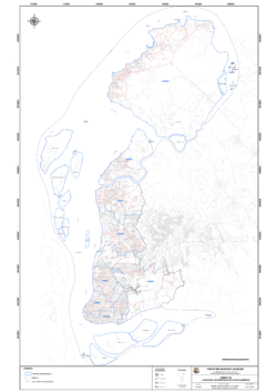
|
|---|---|---|---|
| Center (DABEL) | 8 | Batista Campos • Campina • Cidade Velha • Marco • Nazaré • Reduto • São Brás • Umarizal | |
| Benguí (DABEN) | 8 | Benguí • Cabanagem • Coqueiro • Parque Verde • Pratinha • São Clemente • Tapanã • Una | |
| Entroncamento (DAENT) | 10 | Águas Lindas • Aurá • Castanheira • Curió-Utinga • Guanabara • Mangueirão • Marambaia • Souza • Universitário • Val-de-Cans | |
| Guamá (DAGUA) | 6 | Canudos • Condor • Cremação • Guamá • Jurunas • Montese (Terra Firme) | |
| Icoaraci (DAICO) | 9 | Águas Negras • Agulha • Campina de Icoaraci • Cruzeiro • Maracacueira • Paracuri • Parque Guajará • Ponta Grossa • Tenoné | |
| Mosqueiro (DAMOS) | 19 | Aeroporto • Ariramba • Baía do Sol • Bomfim • Carananduba • Caruará • Chapéu Virado • Farol • Mangueiras • Maracajá • Marahú • Murubira • Natal do Murubira • Paraíso • Porto Arthur • Praia Grande • São Francisco • Sucurijuquara • Vila | |
| Outeiro (DAOUT) | 4 | Água Boa • Brasília • Itaiteua • São João do Outeiro | |
| Sacramenta (DASAC) | 7 | Barreiro • Fátima • Maracangalha • Miramar • Pedreira • Sacramenta • Telegráfo | |
| الإجمالي | 71 | ||
العلاقات الدولية
بليم لها شراكات مع المدن التالية:
المصادر
- ^ IBGE 2020
- ^ نطق البرتغالية الأوروپية هو [bɨˈlɐ̃j].
- ^ Brönstrup Silvestrin, Celsi; Noll, Gisele; Jacks, Nilda (2016). Capitais brasileiras : dados históricos, demográficos, culturais e midiáticos. Ciências da comunicação. Curitiba: Appris Editora. ISBN 9788547302917. OCLC 1003295058. Retrieved 30 April 2017.
- ^ Chavses, Celma (2013). The public market in Belem: architecture and urban insertion (PDF). Uberlândia (Brasil): IV International Colloquium on Trade and City - CINCCI.
- ^ Brönstrup, Silvestrin Celsi; Gisele, Noll; Nilda, Jacks (2016). Capitais brasileiras : dados históricos, demográficos, culturais e midiáticos. Ciências da comunicação. Curitiba, PR: Appris. ISBN 9788547302917. OCLC 1003295058.
- ^ أ ب "Brasil, Pará, Belém, História". Enciclopédia dos Municípios Brasileiros. Instituto Brasileiro de Geografia e Estatística. 2012. Retrieved 2018-03-08.
- ^ Chaves, Celma; Gonçalves, Ana Paula Claudino (2013-03-28). "O mercado público em Belém: arquitetura e inserção urbanística" (PDF). IV Colóquio Internacional sobre o comércio e cidade. Faculdade de Arquitetura e Urbanismo da Universidade de São Paulo. Retrieved 2018-03-08.
- ^ Pereira, Carlos Simões (2020-10-28). "Das origens da Belém seiscentista e sua herança Tupinambá". Revista Científica Multidisciplinar Núcleo do Conhecimento (in البرتغالية البرازيلية) (10): 146–160. ISSN 2448-0959. Retrieved 2022-01-13.
- ^ "Capitania do Grão-Pará". Atlas Digital da América Lusa. Retrieved 2017-12-27.
- ^ "Clima". www.cnpf.embrapa.br. Archived from the original on 2019-02-04. Retrieved 2019-03-30.
- ^ Mota, Maria Aurora Santos da; Tavares, João Paulo Nardin (July 2012). "Condições termodinâmicas de eventos de precipitação extrema em Belém-PA durante a estação chuvosa". Revista Brasileira de Meteorologia. 27 (2): 207–218. doi:10.1590/S0102-77862012000200007. ISSN 0102-7786.
- ^ "Temperatura Média Compensada (°C)" (in البرتغالية). Brazilian National Institute of Meteorology. 1981–2010. Archived from the original on August 14, 2020. Retrieved August 14, 2020.
- ^ "Temperatura Máxima (°C)" (in البرتغالية). Brazilian National Institute of Meteorology. 1981–2010. Archived from the original on August 14, 2020. Retrieved August 14, 2020.
- ^ "Temperatura Mínima (°C)" (in البرتغالية). Brazilian National Institute of Meteorology. 1981–2010. Archived from the original on August 14, 2020. Retrieved August 14, 2020.
- ^ "Precipitação Acumulada Mensal e Anual (mm)" (in البرتغالية). Brazilian National Institute of Meteorology. 1981–2010. Archived from the original on August 14, 2020. Retrieved August 14, 2020.
- ^ "Número de Dias com Precipitação Mayor ou Igual a 1 mm (dias)". Brazilian National Institute of Meteorology. Archived from the original on August 14, 2020. Retrieved August 14, 2020.
- ^ "Insolação Total (horas)". Brazilian National Institute of Meteorology. Archived from the original on August 14, 2020. Retrieved August 14, 2020.
- ^ "Umidade Relativa do Ar Média Compensada (%)". Brazilian National Institute of Meteorology. Archived from the original on August 14, 2020. Retrieved August 14, 2020.
- ^ "Temperatura Máxima Absoluta (ºC)". Brazilian National Institute of Meteorology (Inmet). Retrieved August 14, 2020.
- ^ "Temperatura Mínima Absoluta (ºC)". Brazilian National Institute of Meteorology (Inmet). Retrieved August 19, 2014.[dead link]
- ^ "Belém (82191) - WMO Weather Station". NOAA. Retrieved April 23, 2019.
- ^ "Metals in Belém". 8 October 2005. Archived from the original on 2009-06-15. Retrieved 2009-01-28.
- ^ Japanese Immigration to Pará and Belém Archived فبراير 13, 2009 at the Wayback Machine
- ^ "About Marajó Island". Archived from the original on 2010-04-19. Retrieved 2009-01-28.
- ^ Tucuruí Dam Archived يوليو 6, 2011 at the Wayback Machine
- ^ "Plano Diretor Municipal" [Municipal Directive Plan]. Annex VIII,Municipal LawofError: the
dateoryearparameters are either empty or in an invalid format, please use a valid year foryear, and use DMY, MDY, MY, or Y date formats fordate(in البرتغالية البرازيلية). City Council of Belém.
| الترتيب | الولاية | التعداد | الترتيب | الولاية | التعداد | ||||
|---|---|---|---|---|---|---|---|---|---|
 ساو پاولو  ريو دي جانيرو |
1 | ساو پاولو | ساو پاولو | 11,316,149 | 11 | بلم | پارا | 1,402,056 |  سلڤادور  برازيليا |
| 2 | ريو دي جانيرو | ريو دي جانيرو | 6,355,949 | 12 | گويانيا | گوياس | 1,318,148 | ||
| 3 | سلڤادور | باهيا | 3,093,605 | 13 | گواروليوس | ساو پاولو | 1,233,426 | ||
| 4 | برازيليا | المنطقة الاتحادية | 2,609,997 | 14 | كامپيناس | ساو پاولو | 1,088,611 | ||
| 5 | فورتالزا | سيارا | 2,476,589 | 15 | ساو لويس | مارانياو | 1,027,429 | ||
| 6 | بلو هوريزونتي | ميناز جرايس | 2,385,639 | 16 | ساو گونسالو | ريو دي جانيرو | 1,008,064 | ||
| 7 | مناؤس | أمازوناس | 1,832,423 | 17 | ماسيو | ألاگواس | 943,109 | ||
| 8 | كوريتيبا | پارانا | 1,764,540 | 18 | دوكي دي كاشياش | ريو دي جانيرو | 861,157 | ||
| 9 | رصيفه | پرنامبوكو | 1,536,934 | 19 | ترسينا | پياوي | 822,363 | ||
| 10 | پورتو ألگري | ريو گراند دو سول | 1,413,094 | 20 | ناتال | ريو گراند دو نورته | 810,780 | ||
- ^ "2010 Brazilian Institute of Geography and Statistics estimate". Brazilian Institute of Geography and Statistics. 29 November 2011. Retrieved 22 January 2011.
- Pages using gadget WikiMiniAtlas
- CS1 البرتغالية البرازيلية-language sources (pt-br)
- CS1 البرتغالية-language sources (pt)
- Articles with dead external links from February 2017
- Short description is different from Wikidata
- Pages using multiple image with auto scaled images
- Pages using infobox settlement with possible motto list
- Coordinates on Wikidata
- Articles containing عبرية-language text
- Articles containing برتغالية-language text
- Pages using Lang-xx templates
- Articles with unsourced statements from March 2019
- Articles with hatnote templates targeting a nonexistent page
- مدن ولاية برا
- عواصم البرازيل
- مدن موانئ البرازيل
- مدن تأسست في 1616
