بحيرة هيورون
| Lake Huron | |
|---|---|
| |
 Lake Huron, Georgian Bay, and the frozen North Channel (top) seen from the International Space Station on April 20, 2018 | |
 Lake Huron | |
 | |
| الموقع | North America |
| المجموعة | Great Lakes |
| الإحداثيات | 44°48′N 82°24′W / 44.8°N 82.4°W |
| Lake type | Glacial |
| الموارد الرئيسية | Straits of Mackinac, St. Marys River |
| التصريفات الرئيسية | St. Clair River |
| منطقة المستجمعات | 51،700 ميل مربع (134،000 km2)[8] |
| بلدان الحوض | Canada and the United States |
| أقصى طول | 206 mi (332 km)[8] |
| أقصى عرض | 183 mi (295 km)[8] |
| مساحة السطح | 23،007 ميل مربع (59،590 km2)[8] |
| متوسط العمق | 195 ft (59 m)[8] |
| أقصى عمق | 750 ft (229 m)[8] |
| حجم المياه | 844.8 cu mi (3،521 km3)[8] |
| زمن المكوث | 22 years |
| طول الساحل1 | 1،850 mi (2،980 km) plus 1،980 mi (3،190 km) for islands[9] |
| ارتفاع السطح | 577 ft (176 m)[8] |
| الجزر | Manitoulin |
| القطاعات/الأحواض الفرعية | Georgian Bay, North Channel |
| التجمعات السكنية | Bay City, Alpena, Cheboygan, St. Ignace, Port Huron in Michigan; Goderich, Sarnia, Owen Sound in Ontario |
| المراجع | [10] |
| 1 طول الساحل ليس مقياسًا مضبوطًا. | |

بحيرة هيورونLake Huron هي واحدة من البحيرات العظمى الخمس في أمريكا الشمالية. سميت بهذا الاسم نسبة إلى الهنود الهيورونيين الذين عاشوا على ضفافها. تقع هذه البحيرة بين بحيرة مشيجن وبحيرة إيري، وتشكِّل قسمًا من الحدود بين الولايات المتحدة وكندا. يبلغ طول البحيرة نحو 332 كم. وأكبر عرض لها حوالي 295 كم. وتبلغ مساحتها 59,570 كم²، وتتضمَّن المجرى الشمالي وخليج جورجيان.
وتقع على الارتفاع نفسه من مستوى سطح البحر مثل بحيرة ميتشيجان، 176م. وأعمق جزء فيها 229م ويجري تصريف مياه البحيرة في منطقة مساحتها 133,902كم².
ويربط نهر سانت ماري بحيرة هيورون ببحيرة سوبيريور، وتربط مضايق ماكيناك البحيرة ببحيرة ميتشيجان. وتتدفق مياه بحيرة هيورون في بحيرة إيري بوساطة نهر سانت كلير وبحيرة سانت كلير ونهر دترويت.
وتحوي مياه بحيرة هيورون العذبة أنواعًا عديدة من الأسماك. وتنتشر الجُزر الصغيرة في البحيرة. ومن أهم هذه الجزر: جزيرة ماكيناك في ميتشيجان في الولايات المتحدة، وجزيرة مانيتولين في أونتاريو في كندا. وتجعل العواصف القوية التي تهب بين شهري ديسمبر ومايو الملاحة في بحيرة هيورون خطيرة خلال الشتاء. وضفاف وسواحل البحيرة منخفضة عدا القسم الجنوبي الشرقي من الساحل، إذ ترتفع المنحدرات الصخرية مسافة 46م.
Hydrologically, Lake Huron comprises the eastern portion of Lake Michigan–Huron, having the same surface elevation as Lake Michigan, to which it is connected by the 5-ميل-wide (8.0 km), 20-fathom-deep (120 ft; 37 m) Straits of Mackinac. Combined, Lake Michigan–Huron is the largest freshwater lake by area in the world.[11][12][13] The Huronian glaciation was named from evidence collected from Lake Huron region. The northern parts of the lake include the North Channel and Georgian Bay. Saginaw Bay is located in the southwest corner of the lake. The main inlet is the St. Marys River from Lake Superior, and the main outlet is through the St. Clair River toward Lake Erie. Lake Huron has a fairly large drainage basin covering parts of Michigan and Ontario. Water flows through Lake Huron faster than the other Great Lakes with a retention time of only 22 years.
الجغرافيا
By surface area, Lake Huron is the second-largest of the Great Lakes, with a surface area of 23،007 ميل مربع (59،590 km2)—of which 9،103 ميل مربع (23،580 km2) lies in Michigan and 13،904 ميل مربع (36،010 km2) lies in Ontario—making it the third-largest fresh water lake on Earth (or the fourth-largest lake, if the Caspian Sea is counted as a lake).[8] By volume however, Lake Huron is only the third largest of the Great Lakes, being surpassed by Lake Michigan and Lake Superior.[14] When measured at the low water datum, the lake contains a volume of 850 cubic mile (3،500 km3) and a shoreline length (including islands) of 3،827 mi (6،159 km).[8]
The surface of Lake Huron is 577 أقدام (176 m) above sea level.[8] The lake's average depth is 32 fathoms 3 feet (195 ft; 59 m), while the maximum recorded (by sonar) depth is 125 fathom (750 ft; 229 m).[8] It has a length of 206 statute mile (332 km; 179 nmi) and a greatest breadth of 183 statute mile (295 km; 159 nmi).[8] A large bay that protrudes northeast from Lake Huron into Ontario, Canada, is called Georgian Bay. A notable feature of the lake is Manitoulin Island, which separates the North Channel and Georgian Bay from Lake Huron's main body of water. It is the world's largest lake island.[15] A smaller bay that protrudes southwest from Lake Huron into Michigan is called Saginaw Bay.
Cities with over 10,000 people on Lake Huron include Sarnia, the largest city on Lake Huron, and Saugeen Shores in Canada and Bay City, Port Huron, and Alpena in the United States. Major centres on Georgian Bay include Owen Sound, Wasaga Beach, Collingwood, Midland, Penetanguishene, Port Severn and Parry Sound.
Water levels
Historic high water The lake fluctuates from month to month with the highest lake levels in October and November. The normal high-water mark is 2.00 أقدام (0.61 m) above datum (577.5 ft or 176.0 m). In the summer of 1986, Lakes Michigan and Huron reached their highest level at 5.92 أقدام (1.80 m) above datum.[16] The high-water records were broken for several months in a row in 2020.[17]
Historic low water Lake levels tend to be the lowest in winter. The normal low-water mark is 1.00 قدم (30 cm) below datum (577.5 ft or 176.0 m). In the winter of 1964, Lakes Michigan and Huron reached their lowest level at 1.38 أقدام (42 cm) below datum.[16] As with the high-water records, monthly low-water records were set each month from February 1964 through January 1965. During this twelve-month period, water levels ranged from 1.38 to 0.71 أقدام (42–22 cm) below Chart Datum.[16] The all-time low-water mark was eclipsed in January 2013.[18]
Geology

Lake Huron has the largest shore line length of any of the Great Lakes, counting its 30,000 islands.[11] It is separated from Lake Michigan, which lies at the same level, by the 5-ميل-wide (8.0 km), 20-fathom-deep (120 ft; 37 m) Straits of Mackinac, making them hydrologically the same body of water (sometimes called Lake Michigan-Huron and sometimes described as two 'lobes of the same lake').[11] Aggregated, Lake Huron-Michigan, at 45،300 ميل مربع (117،000 km2), "is technically the world's largest freshwater lake".[11] Lake Superior, at 21 feet higher elevation, drains into the St. Marys River which then flows into Lake Huron. The water then flows south to the St. Clair River, at Port Huron, Michigan and Sarnia, Ontario. The Great Lakes Waterway continues thence to Lake St. Clair; the Detroit River and Detroit, Michigan; into Lake Erie and thence – via Lake Ontario and the St. Lawrence River – to the Atlantic Ocean.
Like the other Great Lakes, it was formed by melting ice as the continental glaciers retreated toward the end of the last ice age. Before this, Lake Huron was a low-lying depression through which flowed the now-buried Laurentian and Huronian Rivers; the lake bed was criss-crossed by a large network of tributaries to these ancient waterways, with many of the old channels still evident on bathymetric maps.
The Alpena-Amberley Ridge is an ancient ridge beneath the surface of Lake Huron, running from Alpena, Michigan, southwest to Point Clark, Ontario.[19]
التاريخ

About 9,000 years ago, when water levels in Lake Huron were approximately 100 m (330 ft) below today's levels, the Alpena-Amberley Ridge was exposed. That land bridge was used as a migration route for large herds of caribou. Since 2008, archaeologists have discovered at least 60 stone constructions along the submerged ridge that are thought to have been used as hunting blinds by Paleo-Indians.[19] That a trade network brought obsidian from Oregon almost ten thousand years ago to be used for toolmaking was confirmed by a 2013 underwater discovery along the ridge.[20]
On the eve of European contact, the extent of development among Eastern Woodlands Native American societies is indicated by the archaeological evidence of a town on or near Lake Huron that contained more than one hundred large structures housing a total population of between 4,000 and 6,000.[21] The French, the first European visitors to the region, often referred to Lake Huron as La Mer Douce, "the fresh-water sea". In 1656, a map by French cartographer Nicolas Sanson refers to the lake by the name Karegnondi, a Wyandot word that has been translated variously, as "Freshwater Sea", "Lake of the Hurons", or simply "lake".[22][23] Generally, the lake was labeled "Lac des Hurons" (Lake of the Huron) on most early European maps.[23]
By the 1860s, many European settlements on the shores of Lake Huron were becoming incorporated, including Sarnia, the largest city on Lake Huron.[24] On October 26, 2010,[25] the Karegnondi Water Authority was formed to build and manage a pipeline from the lake to Flint, Michigan.[26]
Shipwrecks
More than a thousand wrecks have been recorded in Lake Huron. Of these, 185 are located in Saginaw Bay, and 116 are found in the 448-ميل-مربع (1،160 km2) Thunder Bay National Marine Sanctuary and Underwater Preserve, which was established in 2000. Georgian Bay contains 212 sunken vessels.[27]
Purportedly the first European vessel to sail the Great Lakes, Le Griffon also became the first ship lost on the Great Lakes. It was built in 1679 on the eastern shore of Lake Erie near Buffalo, New York. Robert Cavalier, Sieur de la Salle navigated across Lake Erie, up the Detroit River, Lake St. Clair and the St. Clair River out into Lake Huron. Passing the Straits of Mackinac, La Salle made landfall on Washington Island, off the tip of the Door Peninsula on the Wisconsin side of Lake Michigan. La Salle filled Le Griffon with pelts and in late November 1679 sent Le Griffon back to the site of modern-day Buffalo, never to be seen again. Two wrecks have been identified as Le Griffon, although neither has gained final verification as the actual wreck. Blown by a fierce storm after leaving, Le Griffon ran aground before the storm. The people of Manitoulin Island say that the wreck in Mississagi Strait at the western tip of the island is that of Le Griffon.[28][29][30] Meanwhile, others near Tobermory, say that the wreck on Russell Island, 150 ميل (240 km) farther east in Georgian Bay, is that of Le Griffon.[29][31]

View of Lake Huron from East Tawas State Park at the head of Saginaw Bay

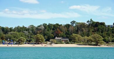
Harrisville Beach on Lake Huron

View of rocky shore of Lake Huron from east of Port Dolomite, Michigan, in the upper peninsula
.jpg&filetimestamp=20241106233611&)


Storm of 1913
On November 9, 1913, the Great Lakes Storm of 1913 in Lake Huron sank 10 ships, and more than 20 were driven ashore. The storm, which raged for 16 hours, killed 235 seamen.[32]
Matoa—a propeller freighter measuring 2,311 gross register tons—had passed between Port Huron, Michigan, and Sarnia, Ontario, just after midnight. On November 9, just after six in the morning, Senator pushed upstream. Less than an hour later, Manola—a propeller freighter of 2,325 gross register tons also built in Cleveland in 1890—passed through. Captain Frederick W. Light of Manola reported that both the Canadian and the American weather stations had storm flag signals flying from their weather towers.[33] Following behind at 7:00 a.m. that Sunday, Regina steamed out of Sarnia into the northwest gale. The warnings had been up for four hours.[34] Manola passed Regina off Port Sanilac, 22 statute mile (19 nmi; 35 km) up the lake. Captain Light determined that if it continued to deteriorate, he would seek shelter at Harbor Beach, Michigan, another 30 statute mile (26 nmi; 48 km) up the lake. There, he could seek shelter behind the breakwater. Before he reached Harbor Beach, the winds turned to the northeast and the lake began to rise. It was noon when he reached Harbor Beach and ran for shelter.
The waves were so violent that Manola touched bottom entering the harbor. With help from a tugboat, Manola tied up to the break wall with eight lines. It was about 3:00 p.m. when Manola was secured and the crew prepared to drop anchor. As they worked, the cables began to snap from wind pressure against the hull. To keep from being pushed aground, they kept their bow into the wind with the engines running half to full in turns, yet the ship still drifted 800 أقدام (240 m) before its movement was arrested.[35] Waves breaking over the ship damaged several windows, and the crew reported seeing portions of the concrete break wall peeling off as the waves struck it.[36] Meanwhile, fifty miles farther up the lake, Matoa and Captain Hugh McLeod had to ride out the storm without a safe harbor.[37] Matoa was found stranded on the Port Austin reef when the winds subsided.[38]
It was noon on Monday before the winds let up and not until 11:00 p.m. that night before Captain Light determined it to be safe to continue his journey.[39] Although Manola survived the storm, she was renamed Mapledawn in 1920, and on November 24, 1924, she became stranded on Christian Island[40] in Georgian Bay. It was declared a total loss. Salvagers were able to recover approximately 75,000 bushels of barley.[41]
Ecology

Lake Huron has a lake retention time of 22 years. Like all of the Great Lakes, the ecology of Lake Huron has undergone drastic changes in the last century. The lake originally supported a native deepwater fish community dominated by lake trout, which fed on several species of ciscos as well as sculpins and other native fishes. Several invasive species, including sea lamprey, alewife and rainbow smelt, became abundant in the lake by the 1930s. The major native top predator, lake trout, was virtually extirpated from the lake by 1950 through a combination of overfishing and the effects of sea lamprey. Several species of ciscos were also extirpated from the lake by the 1960s; the only remaining native ciscoes are bloater and Cisco (lake herring). Non-native Pacific salmon have been stocked in the lake since the 1960s, but are less abundant since a profound food web change that took place in 2003. Lake trout have also been stocked for decades in an attempt to rehabilitate the species and today are largely self sustaining, especially in the northern half of the lake.
Lake Huron has suffered recently by the introduction of a variety of new invasive species, including zebra and quagga mussels, the spiny water flea, and round gobies. The demersal fish community of the lake was in a state of collapse by 2006,[42] and a number of drastic changes have been observed in the zooplankton community of the lake.[43] Chinook salmon catches have also been greatly reduced in recent years, and lake whitefish have become less abundant and are in poor condition. These recent changes may be attributable to the new exotic species. Some native species, however were beneficiaries of these chances (principally a result of the almost complete disappearance of the invasive Alewife in the lake). These native species include Lake Trout and Walleye. The Walleye population in Saginaw Bay area of Lake Huron reached recovery targets in 2009.
Cities
Michigan
Ontario

The cities of Sarnia, Ontario (right) and Port Huron, Michigan (left), located at the southern end of Lake Huron.

View of Parry Sound, Ontario
Shoreline in Goderich, Ontario


.jpg&filetimestamp=20241106233543&)

انظر أيضًا
- Drummond Island
- Georgian Bay
- Hurricane Huron
- Les Cheneaux Islands
- Mackinac Island
- Michigan lighthouses
- Saginaw Bay
- Sauble Beach
- Shipwrecks of the 1913 Great Lakes storm and List of victims of the 1913 Great Lakes storm
- Thunder Bay
- Wasaga Beach
البحيرات العظمى عموماً
- البحيرات العظمى
- Great Lakes Areas of Concern
- Great Lakes census statistical areas
- Great Lakes Commission
- Great Recycling and Northern Development Canal
- Great Storm of 1913
- International Boundary Waters Treaty
- List of cities along the Great Lakes
- Seiche
- Sixty Years' War for control of the Great Lakes
- الساحل الثالث
المصادر
- ^ خطأ استشهاد: وسم
<ref>غير صحيح؛ لا نص تم توفيره للمراجع المسماةGLBathEr - ^ خطأ استشهاد: وسم
<ref>غير صحيح؛ لا نص تم توفيره للمراجع المسماةGLBathHur - ^ خطأ استشهاد: وسم
<ref>غير صحيح؛ لا نص تم توفيره للمراجع المسماةGLBathMich - ^ خطأ استشهاد: وسم
<ref>غير صحيح؛ لا نص تم توفيره للمراجع المسماةGLBathOnt - ^ خطأ استشهاد: وسم
<ref>غير صحيح؛ لا نص تم توفيره للمراجع المسماةGLBathSup - ^ خطأ استشهاد: وسم
<ref>غير صحيح؛ لا نص تم توفيره للمراجع المسماةGLOBE - ^ خطأ استشهاد: وسم
<ref>غير صحيح؛ لا نص تم توفيره للمراجع المسماةNOAA_GLERL - ^ أ ب ت ث ج ح خ د ذ ر ز س ش "Great Lakes Factsheet No. 1". U.S. Environmental Protection Agency. June 25, 2012. Retrieved March 6, 2014.
- ^ "Shorelines of the Great Lakes". Michigan Department of Environmental Quality. Archived from the original on April 5, 2015.
- ^ Wright, John W., ed. (2006). The New York Times Almanac (2007 ed.). New York: Penguin Books. p. 64. ISBN 0-14-303820-6 – via Archive.org.
- ^ أ ب ت ث "Great Lakes Map". Michigan Department of Natural Resources and Environment. Retrieved February 19, 2011.
- ^ "Great Lakes Sensitivity to Climatic Forcing: Hydrological Models". National Oceanic and Atmospheric Administration. 2006. Archived from the original on August 8, 2010.
Lakes Michigan and Huron are considered to be one lake hydraulically because of their connection through the deep Straits of Mackinac." Great Lakes Environmental Research Laboratory, part of the National Oceanic and Atmospheric Administration.
- ^ "Hydrological Components". Record Low Water Levels Expected on Lake Superior (PDF). United States Army Corps of Engineers. August 2007. p. 6. Archived from the original (PDF) on October 15, 2008.
Lakes Michigan and Huron are considered to be one lake, as they rise and fall together due to their union at the Straits of Mackinac
- ^ Annin, Peter (2006). The Great Lakes Water Wars. Island Press. p. 15. ISBN 978-1-55963-087-0.
- ^ "Seven Wonders of Canada-Manitoulin Island, Ontario". CBC.ca. Retrieved October 8, 2016.
- ^ أ ب ت Monthly bulletin of Lake Levels for The Great Lakes. U.S. Army Corps of Engineers, Detroit District. September 2009.
- ^ "Great Lakes Water Level Data". February 3, 2021. Retrieved February 9, 2021.
- ^ "Great Lakes Water Level Data". February 3, 2021. Retrieved February 9, 2021.
- ^ أ ب Weber, Bob (April 29, 2014). "Prehistoric Stone Walls Found Under Lake Huron". CTV News. Canadian Press. Retrieved October 8, 2016.
- ^ Aaron, Martin (June 1, 2021). "At the Bottom of Lake Huron, an Ancient Mystery Materializes". Scientific American. Springer Nature America. Retrieved June 3, 2021.
- ^ Nash, Gary B. (2015). "Chapter 1". Red, White and Black: The Peoples of Early North America. Los Angeles. p. 8.
{{cite book}}: CS1 maint: location missing publisher (link) - ^ Sioui, Georges E. (1999). Huron-Wendat: The Heritage of the Circle. Translated by Brierley, Jane. UBC Press. ISBN 9780774807159.
- ^ أ ب Fonger, Ron (May 3, 2007). "Genesee, Oakland counties adopt historic name for water group". The Flint Journal. Retrieved December 6, 2011.
- ^ "Lake Huron at the time of Confederation". University of Toronto Archives: Showcase 150. Retrieved January 28, 2020.
- ^ Thorne, Blake (October 27, 2010). "Karegnondi Water Authority sets course for cutting ties with Detroit water". Flint Journal. Retrieved December 6, 2011.
- ^ Fonger, Ron (October 23, 2010). "Years in the making, Karegnondi Water Authority is ready to set new course for water". Flint Journal. Retrieved December 6, 2011.
- ^ Parker, Jack (1986). Shipwrecks of Lake Huron . . . The Great Sweetwater Sea. Au Train, Michigan: Avery Color Studios. pp. 65–77.
- ^ Allen, Durward L. (September 1959). "Lasalle's Griffin?". Boys' Life. Boy Scouts of America. pp. 19, 76–77.
- ^ أ ب "Mississagi Lighthouse". Archived from the original on July 12, 2013. Retrieved July 1, 2013.
{{cite web}}: CS1 maint: bot: original URL status unknown (link) - ^ "The Griffon: First Ghost Ship on the Great Lakes". Michigansotherside.com. Archived from the original on June 23, 2009. Retrieved July 12, 2013.
- ^ Parker (1986), pp. 25–26.
- ^ Boyer, Dwight (1984). True Tales of the Great Lakes. New York: Dodd, Mead. p. 212. ISBN 9780396083481.
- ^ Boyer (1984), p. 266.
- ^ Boyer (1984), p. 268.
- ^ Barcus, Frank (1986). Freshwater Fury: Yarns and Reminiscences of the Greatest Storm in Inland Navigation. Great Lakes Books Series. Detroit: Wayne State University Press. p. 72. ISBN 9780814318287.
- ^ Boyer (1984), p. 269.
- ^ Boyer (1984), pp. 272–273.
- ^ Parker (1986), p. 56.
- ^ Barcus (1986), p. 73.
- ^ Parker (1986), p. 71.
- ^ Great Lakes Vessels Index. Historical Collections of the Great Lakes. Bowling Green, Ohio: Bowling Green State University.
- ^ Riley, Stephen C.; Roseman, Edward F.; Nichols, S. Jerrine; O'Brien, Timothy P.; Kiley, Courtney S.; Schaeffer, Jeffrey S. (November 2008). "Deepwater demersal fish community collapse in Lake Huron". Transactions of the American Fisheries Society. Vol. 137, no. 6. pp. 1879–1880. doi:10.1577/T07-141.1.
- ^ Barbiero, Richard P.; Balcer, Mary; Rockwell, David C.; Tuchman, Marc L. (April 2009). "Recent shifts in the crustacean zooplankton community of Lake Huron". Canadian Journal of Fisheries and Aquatic Sciences. Vol. 66, no. 5. pp. 816–828. doi:10.1139/F09-036.
للاستزادة
- Hyde, Charles K., and Ann and John Mahan. The Northern Lights: Lighthouses of the Upper Great Lakes. Detroit: Wayne State University Press, 1995. ISBN 0814325548 ISBN 9780814325544.
- Oleszewski, Wes, Great Lakes Lighthouses, American and Canadian: A Comprehensive Directory/Guide to Great Lakes Lighthouses, (Gwinn, Michigan: Avery Color Studios, Inc., 1998) ISBN 0-932212-98-0.
- Penrod, John, Lighthouses of Michigan, (Berrien Center, Michigan: Penrod/Hiawatha, 1998) ISBN 9780942618785 ISBN 9781893624238.
- Penrose, Laurie and Bill, A Traveler’s Guide to 116 Michigan Lighthouses (Petoskey, Michigan: Friede Publications, 1999). ISBN 0923756035 ISBN 9780923756031
- Wagner, John L., Michigan Lighthouses: An Aerial Photographic Perspective, (East Lansing, Michigan: John L. Wagner, 1998) ISBN 1880311011 ISBN 9781880311011.
- Wright, Larry and Wright, Patricia, Great Lakes Lighthouses Encyclopedia Hardback (Erin: Boston Mills Press, 2006) ISBN 1550463993
وصلات خارجية
| Lake Huron
]].- EPA's Great Lakes Atlas
- Fish Species of Lake Huron
- Great Lakes Coast Watch
- Lake Huron Binational Partnership Action Plan
- Lake Huron Data
- Lake Huron GIS
- Michigan DNR map of Lake Huron
- Bathymetry of Lake Huron
- Lighthouses
- Bibliography on Michigan lighthouses
- Interacitvew map of lighthouses, Georgian Bay, Lake Huron
- Interactive map of lighthouses in North and East Lake Huron
- Interactive map of lighthouses in North and West Lake Huron
- Terry Pepper on lighthouses of the Western Great Lakes
- Wagner, John L., Beacons Shining in the Night, Michigan lighthouse bibliography, chronology, history, and photographs, Clarke Historical Library, Central Michigan University
| البحيرات الرئيسية |  | |
|---|---|---|
| البحيرات الثانوية | ||
| الممرات المائية | ||
| قوائم الجزر | ||
| Historic geology | ||
| شواطئ البحيرات | ||
| مواضيع متعلقة | ||
قالب:Central Michigan قالب:Northern Michigan
| Central cities | |
|---|---|
| Counties | |
| Geography | |
| Transportation | |
| Economy | |
- Pages using gadget WikiMiniAtlas
- CS1 maint: location missing publisher
- CS1 maint: bot: original URL status unknown
- Short description is different from Wikidata
- Articles containing Ojibwe-language text
- Coordinates on Wikidata
- Articles containing Wyandot-language text
- Articles with hatnote templates targeting a nonexistent page
- Lake Huron
- Lakes of Ontario
- Great Lakes Waterway
- Lakes of Michigan
- Canada–United States border
- International lakes of North America
- Great Lakes
- البحيرات العظمى
- البحيرات العظمى Waterway
- International lakes