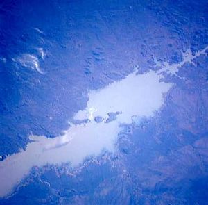
زمبزي
| نهر زمبزي Zambesi, Zambeze | |
|---|---|
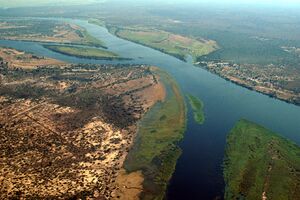 نهر زمبزي عند إلتقاء حدود ناميبيا وزامبيا وزمبابوى وبوتسوانا | |
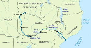 | |
| الكنية | Besi |
| الاسم المحلي | Zambezi (إنگليزية) |
| الموقع | |
| البلدان | |
| السمات الطبيعية | |
| المنبع | منبع الجذع الرئيسي. غابة منبع الزمبزي الوطنية |
| ⁃ الموقع | Ikelenge District, North-Western Province, زامبيا |
| ⁃ الإحداثيات | 11°22′11″S 24°18′30″E / 11.36972°S 24.30833°E |
| ⁃ المنسوب | 1،500 m (4،900 ft) |
| 2nd source | أبعد منبع لنظام زمبزي-لونگوىبونگو |
| ⁃ الموقع | بلدية موكسيكو، مقاطعة موكسيكو، أنگولا |
| ⁃ الإحداثيات | 12°40′34″S 18°24′47″E / 12.67611°S 18.41306°E |
| ⁃ المنسوب | 1,440 متر |
| المصب | المحيط الهندي |
- الموقع | مقاطعة زمبزيا و مقاطعة سفالة، موزمبيق |
- الإحداثيات | 18°34′14″S 36°28′13″E / 18.57056°S 36.47028°E |
| الطول | 2574 كم |
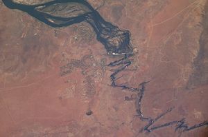
| مساحة الحوض | 1،390،000 km2 (540،000 sq mi)[1][2] |
| التدفق | |
| ⁃ الموقع | Zambezi Delta, Mozambique, Indian Ocean |
| ⁃ المتوسط | 3،424 m3/s (120،900 cu ft/s)[1][2]
4،134 m3/s (146،000 cu ft/s)[3] 3،896.189 m3/s (137،592.6 cu ft/s)[4] |
| ⁃ أدنى تدفق | 920 m3/s (32،000 cu ft/s) |
| ⁃ أقصى تدفق | 18،600 m3/s (660،000 cu ft/s) |
| التدفق | |
| ⁃ الموقع | سد كاهورا بسا (حجم الحوض: 1,068,237 كم²) |
| ⁃ المتوسط | 2،652.541 m3/s (93،673.6 cu ft/s)[4] |
| التدفق | |
| ⁃ الموقع | سد كاريبا (حجم الحوض: 679,343.6 كم² |
| ⁃ المتوسط | 1،315.381 m3/s (46،452.2 cu ft/s)[5] |
| التدفق | |
| ⁃ الموقع | شلالات ڤيكتوريا |
| ⁃ المتوسط | 1،065.982 m3/s (37،644.8 cu ft/s)[5] |
| التدفق | |
| ⁃ الموقع | لوكولو |
| ⁃ المتوسط | 1،287.923 m3/s (45،482.6 cu ft/s)[6] |
| سمات الحوض | |
| النظام النهري | حوض الزامبزي |
| الروافد | |
| - اليسرى | Luena, لونگوىبونگو، Luanginga, Chobe, Gwayi, Sanyati, Panhane, Luenha |
| - اليمنى | Kabompo, Kafue, Luangwa, Capoche, Shire |
 | |
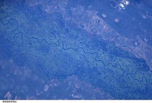
نهر الزمبيزي (also spelled Zambeze and Zambesi) هو رابع أطول نهر في أفريقيا، وأطول نهر ينساب إلى الشرق في أفريقيا والأكثر تدفقاً إلى المحيط الهندي من أفريقيا. مساحة حوض تصريفه هي 1,390,000 كم²،[1][2] أي أقل قليلاً من نصف حوض النيل. النهر الذي ينبع في زامبيا، بالقرب من الحدود بين الكونغو الديمقراطية وأنگولا، ويسير في مجرى ملتو طوله 2,637 كم. هو رابع أطول الأنهار في إفريقيا حيث تُعَدُّ أنهار النيل والكونغو والنيجر أطول منه. يفصل النهر بين زامبيا وزمبابوه، ويقَطع موزمبيق إلى قناة موزمبيق.
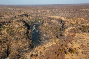
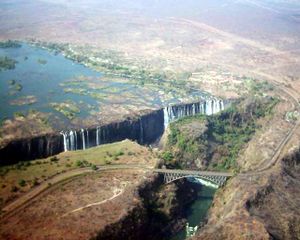
يقع الجزء الأعلى من النهر في أرض مستوية، حيث يعتمد إمداد المياه على الأمطار الاستوائية التي تسقط في الفترة الممتدة من شهر أكتوبر حتى شهر مارس. يهبط النهر من هذه الهضبة إلى مستوى أكثر انخفاضًا فوق شلالات فكتوريا، تلك الشلالات المائية الضخمة، حيث يوجد مصنع مزوَّد بالكهرباء المولدة من القوة المائية منذ عام 1938م. وفي عام 1959م، بُني سد كاريبا الذي يقع في خانق كاريبا أسفل النهر بمسافة 320 كم، ويكوَّن بحيرة تغطي 5,200 كم². الشلالات الأخرى تضم شلالات تشاڤوما[7] at the border between Zambia and Angola, and Ngonye Falls near Sioma in western Zambia.[8]
المصدران الرئيسيان للطاقة الكهرمائية على النهر هما سد كاريبا، الذي يمد بالكهرباء كلاً من زامبيا وزيمبابوى، و سد كاهورا بسا في موزمبيق، الذي يزود بالطاقة كلاً من موزمبيق وجنوب أفريقيا. وبالإضافة لذلك، توجد محطتان أصغر لتوليد الطاقة على نهر زمبزي في زامبيا، واحدة في شلالات ڤيكتوريا والأخرى في زنگامينا، بالقرب من ربوة كالنى في Ikelenge District.[9][10]
مسار النهر
المنابع
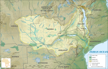
The river rises in a black marshy dambo in dense undulating miombo woodland 50 كيلومتر (31 mi) north of Mwinilunga and 20 كيلومتر (12 mi) south of Ikelenge in the Ikelenge District of North-Western Province, Zambia at about 1،524 متر (5،000 ft) above sea level.[11] The area around the source is a national monument, forest reserve and Important Bird Area.[12]
Eastward of the source, the watershed between the Congo and Zambezi basins is a well-marked belt of high ground, running nearly east–west and falling abruptly to the north and south. This distinctly cuts off the basin of the Lualaba (the main branch of the upper Congo) from that of the Zambezi. In the neighborhood of the source the watershed is not as clearly defined, but the two river systems do not connect.[13]
The region drained by the Zambezi is a vast broken-edged plateau 900–1200 m high, composed in the remote interior of metamorphic beds and fringed with the igneous rocks of the Victoria Falls. At Shupanga, on the lower Zambezi, thin strata of grey and yellow sandstones, with an occasional band of limestone, crop out on the bed of the river in the dry season, and these persist beyond Tete, where they are associated with extensive seams of coal. Coal is also found in the district just below Victoria Falls. Gold-bearing rocks occur in several places.[14]
الزمبزي الأعلى
الزمبزي الأوسط
الدلتا

التاريخ
استكشاف النهر
يُرجَّح أن الجغرافيين الأوائل قد عرفوا منطقة الزمبيزي عن طريق التجار العرب. وكان ديفيد ليفنجستون هو أول أوروبي يصل إلى نهر الزمبيزي في فترة الخمسينيات والستينيات من القرن التاسع عشر الميلادي.
ويرتبط كشف هذا النهر باسم الرحالة لفنجستون David Livingstone الذي فتح هذه المناطق أمام البعثات التنصيرية، فعلى الرغم من ذيوع شهرته كمكتشف للقارة الافريقية، وقد أمد الاوروبيين بمعلومات جغرافية واثنوجرافية وطبية الا أنه ظل متعصبا للتنصير حتى آخر يوم في حياته. ولفنجستون اسكتلندي الأصل انضم الى جمعية لندن التنصيرية عام 1838 وعمل في جامعة جلاسجوـ، وتدرب على أعمال الزراعة والصناعة والتجارة ليقوم بنشاطه التنصيرية، ولكنه تراجع وفضل العمل في أفريقيا. وذلك بسبب اضطراب أحوال الصين بسبب حرب الافيون.
وترجع أهمية وخطورة اكتشافات لفنجستون أنه فتح الباب أمام البعثات التنصيري البريطانية، فبعد أن كان مركز التنصير الرئيسي في كورومان في جنوب أفريقيا، أصبح هناك العديد من المراكز في داخل القارة، فقد توغل لفنجستون في مناطق لم يصل اليها اوروبي من قبل، وقد ساعده في عمله الكشفي والتنصيري اتصاله بالمنصر البريطاني الدكتور روبرت موفات الذي عمل في جنوب أفريقيا وتزوج من ابنته وتوثقت الصلات بينهما بدرجة كبيرة، قام لفنجستون بثلاث رحلات الى أفريقيا، بدأت الأولى 1841 – 1859 واتخذ من كورومان مركز للانطلاق والتوغل داخل القارة، ثم عبر صحراء كلهاري ونجح في الوصول الى أراضي الباروتسي (في روديسيا الشمالية) وتتبع مجرى نهر الزمبيزي حتى مصبه مكتشفاً المساقط المائية التي تعترض مجرى النهر وأطلق عليها شلالات فيكتوريا نسبة الى ملكة بريطانيا.
أما الرحلة الثانية 1858 0 1864 فقد استأنفت فيها اكتشاف مجرى نهر الزمبيزي ووصل الى نهر شيريه أحد فروعه ثم وصل الى بحيرة نياسا. أما رحلته الثالثة 1866 – 1873 تلك الرحلة التي كلفته بها الجمعية الجغرافية الملكية في لندن فقد كان الهدف منها فض لغز شبكة الأنهار في وسط أفريقيا والتأكد من الأنهار والبحيرات فيها وتأكيد اكتشافات غيره من المكتشفين.
الاقتصاد
النقل
الحياة البرية
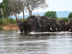
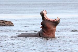
The river supports large populations of many animals. Hippopotamuses are abundant along most of the calm stretches of the river, as well as Nile crocodiles. Monitor lizards are found in many places. Birds are abundant, with species including heron, pelican, egret, lesser flamingo and African fish eagle present in large numbers. Riverine woodland also supports many large animals, such as buffalo, zebras, giraffes, elephants.[بحاجة لمصدر]
The Zambezi also supports several hundred species of fish, some of which are endemic to the river. Important species include cichlids which are fished heavily for food, as well as catfish, tigerfish, yellowfish and other large species. The bull shark is sometimes known as the Zambezi shark after the river, but is found around the world.
الروافد
Upper Zambezi: 507,200 km2, discharges 1044 m3/s at Victoria Falls, comprising:
- Northern Highlands catchment, 222,570 km2, 850 m3/s عند لوكولو:
- Chifumage River: Angolan central plateau
- Luena River: Angolan central plateau
- Kabompo River: 72,200 km2, NW highlands of Zambia
- Lungwebungu River: 47,400 km2, Angolan central plateau
- Central Plains catchment, 284,630 km2, 196 m3/s (Victoria Falls–Lukulu):
- Luanginga River: 34,600 km2, Angolan central plateau
- Luampa River/Luena River, Zambia: 20,500 km2, eastern side of Zambezi
- Cuando /Linyanti/Chobe River: 133,200 km2, Angolan S plateau & Caprivi
Middle Zambezi cumulatively 1,050,000 km2, 2442 m3/s, measured at Cahora Bassa Gorge
- (Middle section by itself: 542,800 km2, discharges 1398 m3/s (C. Bassa–Victoria Falls)
- Gwembe Catchment, 156,600 km2, 232 m3/s (Kariba Gorge–Vic Falls):
- Gwayi River: 54,610 km2, NW Zimbabwe
- Sengwa River: 25,000 km2, North-central Zimbabwe
- Sanyati River: 43,500 km2, North-central Zimbabwe
- Kariba Gorge to C. Bassa catchment, 386200 km2, 1166 m3/s (C. Bassa–Kariba Gorge):
- Kafue River: 154,200 km2, 285 m3/s, West-central Zambia & Copperbelt
- Luangwa River: 151,400 km2, 547 m3/s, Luangwa Rift Valley & plateau NW of it
- Panhane River: 23,897 km2, North-central Zimbabwe plateau
Lower Zambezi cumulatively, 1,378,000 km2, 3424 m3/s, measured at Marromeu
- (Lower section by itself: 328,000 km2, 982 m3/s (Marromeu–C. Bassa))
- Luia River: 28,000 km2, Moravia-Angonia plateau, N of Zambezi
- Luenha River/Mazoe River: 54,144 km2, 152 m3/s, Manica plateau, NE Zimbabwe
- Shire River , 154,000 km2, 539 m3/s, Lake Malawi basin
- Zambezi Delta, 12,000 km2
Total Zambezi river basin: 1,390,000 km2, 3424 m3/s discharged into delta
Source: Beilfuss & Dos Santos (2001)[1] The Okavango Basin is not included in the figures because it only occasionally overflows to any extent into the Zambezi.
Due to the rainfall distribution, northern tributaries contribute much more water than southern ones, for example: the Northern Highlands catchment of the upper Zambezi contributes 25%, Kafue 8%, Luangwa and Shire Rivers 16% each, total 65% of Zambezi discharge. The large Cuando basin in the south-west on the other hand contributes only about 2 m3/s because most is lost through evaporation in its swamp systems. The 1940s and 1950s were particularly wet decades in the basin. Since 1975, it has been drier, the average discharge being only 70% of that for the years 1930 to 1958.[1]
التاريخ الجيولوجي
Up to the Late Pliocene or Pleistocene (more than two million years ago), the Upper Zambezi river used to flow south through what is now the Makgadikgadi Pan to the Limpopo River.[16] The change of the river course is the result of epeirogenic movements that uplifted the surface at the present-day water divide between both rivers.[17]
Meanwhile, 1،000 كيلومتر (620 mi) east, a western tributary of the Shire River in the East African Rift's southern extension through Malawi eroded a deep valley on its western escarpment. At the rate of a few cm per year, this river, the Middle Zambezi, started cutting back the bed of its river towards the west, aided by grabens (rift valleys) forming along its course in an east–west axis. As it did so it captured a number of south-flowing rivers such as the Luangwa and Kafue.
Eventually the large lake trapped at Makgadikgadi (or a tributary of it) was captured by the Middle Zambezi cutting back towards it, and emptied eastwards. The Upper Zambezi was captured as well. The Middle Zambezi was about 300 متر (980 ft) lower than the Upper Zambezi, and a high waterfall formed at the edge of the basalt plateau across which the upper river flows. This was the first Victoria Falls, somewhere down the Batoka Gorge near where Lake Kariba is now.[18]
البيئة
البلدات الكبرى
Along much of the river's length, the population is sparse, but important towns and cities along its course include the following:
- Katima Mulilo (Namibia)
- Mongu, Lukulu, Livingstone and Sesheke (Zambia)
- Victoria Falls and Kariba (Zimbabwe)
- Songo and Tete (Mozambique)
البلدات الكبرى
Along much of the river's length, the population is sparse, but important towns and cities along its course include the following:
- Katima Mulilo (ناميبيا)
- Mongu, لوكولو, Livingstone, & Sesheke (زامبيا)
- Victoria Falls & Kariba (زمبابوه)
- Songo & Tete (موزمبيق)
انظر أيضاً
المصادر
- ^ أ ب ت ث ج "Richard Beilfuss & David dos Santos: Patterns of Hydrological Change in the Zambezi Delta, Monogram for the Sustainable Management of Cahora Bassa Dam and The Lower Zambezi Valley (2001). Estimated mean flow rate 3424 m³/s" (PDF). Archived from the original (PDF) on 17 December 2008. Retrieved 18 October 2008.
- ^ أ ب ت International Network of Basin Organisations/Office International de L'eau: Archived 27 مارس 2009 at the Wayback Machine "Développer les Compétences pour mieux Gérer l'Eau: Fleuves Transfrontaliers Africains: Bilan Global." (2002). Estimated annual discharge 106 km3, equal to mean flow rate 3360 m3/s
- ^ "The Zambezi River Basin - A Multi Sector Investment Opportunities - Volume 4-Modelling, Analysis and Input Data" (PDF). Jun 2010.
- ^ أ ب "Rivers Network". 2020.
- ^ أ ب "Rivers Network". 2020.
- ^ "Rivers Network". 2020.
- ^ "Chavuma Falls | waterfall, Zambia | Britannica". www.britannica.com (in الإنجليزية). Retrieved 2022-06-26.
- ^ "Zambia Tourism: Waterfalls". Zambia Tourism (in الإنجليزية الأمريكية). Retrieved 2022-06-25.
- ^ Pasanisi, Francesco; Tebano, Carlo; Zarlenga, Francesco (March 2016). "A Survey near Tambara along the Lower Zambezi River". Environments (in الإنجليزية). 3 (1): 6. doi:10.3390/environments3010006.
- ^ "Zengamina Hydro Project | North West Zambia Development Trust" (in الإنجليزية الأمريكية). Retrieved 2022-04-18.
- ^ "Dilapidated Zambezi Source Site Worry Ikelenge DC". muvitv.com. Muvi TV. Archived from the original on 4 September 2015. Retrieved 1 August 2015.
- ^ "ZM002 Source of the Zambezi". birdlife.org. Birdlife International. Retrieved 1 August 2015.
- ^ Dorling Kindersley, pp. 84–85
- ^ Ashton, Peter; Love, David; Mahachi, Harriet; Dirks, Paul. "An Overview of the Impacts of Mining and Mineral Processing Operations on Water Resources and Water Quality in the Zambezi, Limpopo AND Olifant Catchments in Southern Africa" (PDF). International Institute for Environment and Development. Mining, Minerals and Sustainable Development Project, Southern Africa. Retrieved 13 November 2020.
- ^ rec.php?id=5070 NASA: "Visible Earth" website accessed 1 March 2007
- ^ Goudie, A.S. (2005). "The drainage of Africa since the Cretaceous". Geomorphology. 67 (3–4): 437–456. doi:10.1016/j.geomorph.2004.11.008.
- ^ Moore, A.E. (1999). "A reapprisal of epeirogenic flexure axes in southern Africa". South African Journal of Geology. 102 (4): 363–376.
- ^ AWF Four Corners Biodiversity Information Package No 2: Summary of Technical Reviews Archived 17 فبراير 2012 at the Wayback Machine Accessed 1 March 2007.(dead link)
مصادر عامة
- المعرفية الشاملة
- Bento C.M., Beilfuss R. (2003), Wattled Cranes, Waterbirds, and Wetland Conservation in the Zambezi Delta, Mozambique, report for the Biodiversity Foundation for Africa for the IUCN - Regional Office for Southern Africa: Zambezi Basin Wetlands Conservation and Resource Utilisation Project.
- Bourgeois S., Kocher T., Schelander P. (2003), Case study: Zambezi river basin, ETH Seminar: Science and Politics of International Freshwater Management 2003/04
- Davies B.R., Beilfuss R., Thoms M.C. (2000), "Cahora Bassa retrospective, 1974–1997: effects of flow regulation on the Lower Zambezi River," Verh. Internat. Verein. Limnologie, 27, 1–9
- Dunham KM (1994), The effect of drought on the large mammal populations of Zambezi riverine woodlands, Journal of Zoology, v. 234, p. 489–526
- Dorling Kindersley Publishing, Inc. (2004). World reference atlas. New York: Dorling Kindersley. ISBN 0756604818
- Wynn S. (2002), "The Zambezi River - Wilderness and Tourism", International Journal of Wilderness, 8, 34.
- H. C. N. Ridley: “Early History of Road Transport in Northern Rhodesia”, The Northern Rhodesia Journal, Vol 2 No 5 (1954)—Re Zambezi River Transport Service at Katombora.
وصلات خارجية
- Information and a map of the Zambezi's watershed
- Zambezi Expedition - Fighting Malaria on the "River of Life"
- Zambezi River Authority
- The Zambezi Society
- Map of Africa's river basins
- Visit Zambia Campaign
- Bibliography on Water Resources and International Law Peace Palace Library
- The Nature Conservancy's Great Rivers Partnership works to conserve the Zambezi River
- CS1 الإنجليزية الأمريكية-language sources (en-us)
- Short description is different from Wikidata
- Articles containing إنگليزية-language text
- Pages using gadget WikiMiniAtlas
- Infobox mapframe without OSM relation ID on Wikidata
- Pages using infobox river with unknown parameters
- Articles with unsourced statements from September 2017
- أنهار أنگولا
- نهر زمبيزي
- أنهار موزمبيق
- أنهار زامبيا
- أنهار زمبابوي
- أنهار ناميبيا
- حوض زمبزي
- Visitor attractions in Zimbabwe
- أنهار دولية في أفريقيا
- قناة موزمبيق
- أنهار أفريقيا
- صفحات مع الخرائط


