ألموپيا
ألموپيا
Αλμωπία | |
|---|---|
 | |
| الإحداثيات: 40°58′N 22°03′E / 40.967°N 22.050°E | |
| البلد | |
| المنطقة الادارية | مقدونيا الوسطى |
| الوحدة المحلية | Pella |
| الحكومة | |
| • العمدة | Dimitris Pasois |
| المساحة | |
| • البلدية | 985٫8 كم² (380٫6 ميل²) |
| التعداد (2011)[1] | |
| • البلدية | 27٬556 |
| • كثافة البلدية | 28/km2 (72/sq mi) |
| منطقة التوقيت | UTC+2 (EET) |
| • الصيف (التوقيت الصيفي) | UTC+3 (EEST) |
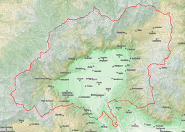
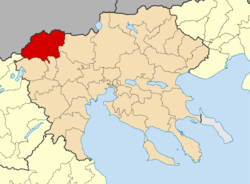
ألموپيا (باليونانية: Αλμωπία؛ Almopia)، أو Enotia, also known in the Middle Ages as Moglena (Greek: Μογλενά, Macedonian and Bulgarian: Меглен or Мъглен), is a municipality and a former province (επαρχία) of the Pella regional unit in Macedonia, اليونان. The seat of the municipality is the town Aridaia.[2] The municipality has an area of 985.817 km2.[3]
الاسم والتاريخ
The name Almopia (باليونانية قديمة: Ἀλμωπία, Almōpia) derives from the Almopes (Ἀλμῶπες), a Paeonian tribe that originally inhabited the area during Antiquity. The Almopes traced their descent to the eponymous mythological figure of Almops, son of Poseidon and Helle.[4] وحسب Thucidydes, the Almopes were expelled from the region when it was incorporated into the ancient Macedonian kingdom during the reign of Alexander I (r. 498–454 BC).[5] The 2nd-century astronomer and geographer Claudius Ptolemy records three cities in the region in his Geography: Horma (Ὅρμα), Europos (Εὔρωπος) and Apsalos (Ἄψαλος).
In the early Byzantine period, the area was renamed to Enotia (Greek: Ενωτία) after a nearby fortress, probably in the vicinity of modern Notia. The name was revived between 1915 and 1927 for the Greek province as well.[6][7]
In the later Middle Ages, the area was known as Moglena (Greek: Μογλενά, مقدونية: Меглен, بالبلغارية: Мъглен), from the Slavic word for "fog".[8] Until the early 11th century, Moglena was a province of the First Bulgarian Empire. Captured by the Byzantine emperor Basil II in 1015, it is attested as the seat of a bishopric in 1020, and as capital of its own theme in 1086. The area remained under Byzantine rule until the aftermath of the Fourth Crusade, when it was captured by Tsar Kaloyan of the Second Bulgarian Empire.[9] It was incorporate in the Serbian Empire by Stefan Dušan in 1346. Moglena was inhabited mainly by Megleno-Romanians and Slavic people. In Ottoman times, the region was also known by its Turkish name Karacova or Karadjova valley ("Black Valley", Greek: Καρατζόβα).
Until the Greco-Turkish War (1919–1922) and the population exchange between Greece and Turkey in 1924, Muslim Vlachs and Pomaks inhabited a large part of the regions of Moglena.[10]
البلدية
The municipality Almopia was formed at the 2011 local government reform by the merger of the following 2 former municipalities, that became municipal units:[2]
Province
The province of Almopia (Επαρχία Αλμωπίας) was one of the three provinces of Pella Prefecture. Its territory corresponded with that of the current municipality of Almopia.[11] It was abolished in 2006.
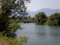
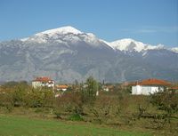
معرض صور
انظر أيضاً
المراجع
- ^ أ ب "Απογραφή Πληθυσμού - Κατοικιών 2011. ΜΟΝΙΜΟΣ Πληθυσμός" (in اليونانية). Hellenic Statistical Authority.
- ^ أ ب Kallikratis law Greece Ministry of Interior (باليونانية)
- ^ "Population & housing census 2001 (incl. area and average elevation)" (PDF) (in اليونانية). National Statistical Service of Greece. Archived from the original (PDF) on 2015-09-21.
- ^ Schmitz, Leonhard (1867). "Almops". In William Smith (ed.). Dictionary of Greek and Roman Biography and Mythology. Vol. 1. Boston: Little, Brown and Company. p. 132.
- ^ Thucydides, History of the Peloponnesian War, II.99
- ^ Agni K. Koliadymou (2006). Από την Αξό Καππαδοκίας στο Νομό Πέλλας: Προσφυγικές Διαδρομές (1890-1940) (PDF). Thessaloniki. p. 117.
{{cite book}}: CS1 maint: location missing publisher (link) - ^ ΦΕΚ 304/27-12-1927
- ^ Wolfgang Dahmen; Johannes Kramer (1986). "Das Meglenorumänische". Rumänistik in der Diskussion. Tübingen. p. 262. ISBN 3-87808-859-0.
{{cite book}}: CS1 maint: location missing publisher (link) - ^ Kazhdan, Alexander (1991). "Moglena". In Kazhdan, Alexander (ed.). The Oxford Dictionary of Byzantium. Oxford and New York: Oxford University Press. p. 1389. ISBN 978-0-19-504652-6.
- ^ Theodor Capidan, Meglenoromânii, istoria şi graiul lor Archived 2016-03-03 at the Wayback Machine, vol. I, Bucureşti, 1925, p.5, 19, 21-22)
- ^ "Detailed census results 1991" (PDF). Archived from the original (PDF) on 2016-03-03. (39 MB) (باليونانية) (بالفرنسية)
وصلات خارجية
- Pages using gadget WikiMiniAtlas
- CS1 اليونانية-language sources (el)
- CS1 maint: location missing publisher
- Short description is different from Wikidata
- Coordinates on Wikidata
- Articles containing Greek-language text
- Articles containing Ancient Greek (to 1453)-language text
- Articles containing مقدونية-language text
- Articles containing بلغارية-language text
- مقدونيا العليا
- بلديات مقدونيا الوسطى
- Populated places in Pella (regional unit)
- مراكز اليونان


