فير
Fier | |
|---|---|
 | |
| الإحداثيات: 40°43′30″N 19°33′30″E / 40.72500°N 19.55833°E | |
| البلد | |
| المقاطعة | Fier |
| المنسوب | 44 m (144 ft) |
| التعداد (2015) | |
| • البلدية | 85٬845 |
| • الوحدة البدية | 120٬655 |
| صفة المواطن | Fierak/e |
| منطقة التوقيت | UTC+1 (ت.و.أ.) |
| • الصيف (التوقيت الصيفي) | UTC+2 (ت.و.أ.ص.) |
| الموقع الإلكتروني | Official Website |
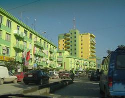
فـير (الصيغة الألبانية الرسمية: Fieri؛ إنگليزية: Fier) هي مدينة وبلدية في مقاطعة فير في جنوب غرب ألبانيا. تعداد البلدية في إحصاء 2011 كان 85,845 نسمة.[1]
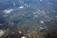
Geographically, it is located on the center of the country surrounded by hills. The city is located some 16 kilometres east of the Adriatic Sea and 100 kilometres south of Tirana.
Fier is 11 km (7 mi) from the ruins of the ancient city of Apollonia. The city was founded in 588 BCE by Greek colonists from Corfu and Corinth,[2] on a site initially occupied by Illyrian tribes.[3]
. . . . . . . . . . . . . . . . . . . . . . . . . . . . . . . . . . . . . . . . . . . . . . . . . . . . . . . . . . . . . . . . . . . . . . . . . . . . . . . . . . . . . . . . . . . . . . . . . . . . . . . . . . . . . . . . . . . . . . . . . . . . . . . . . . . . . . . . . . . . . . . . . . . . . . . . . . . . . . . . . . . . . . . .
أصل الاسم
The name comes from Albanian meaning fern. A hypothesis is that the name of the city comes probably from the Italian word fiera, meaning trade fair in English.[4]
التاريخ
The history of Fier is bound up with that of the oil, gas and bitumen deposits nearby. The presence of asphalt and burning escapes of natural gas in the vicinity was recorded as early as the 1st century AD. Dioscorides, in Materia Medica, describes lumps of bitumen in the adjacent river Seman, and the concentrated pitch on the banks of the Vjosë river Strabo, writing in about AD 17 states:
On the territory of the people of Apolonia in Illyria there is what is called a nymphaeum. It is a rock which emits fire. Below it are springs flowing with hot water and asphalt... the asphalt is dug out of a neighboring hill: the parts excavated are replaced by fresh earth, which in time is converted to asphalt.
In the 14th and 15th century the location was used by the Venetian traders as a marketplace to purchase agricultural products from the Myzeqe lowlands.[4]
The settlement took city status in 1864 when Kahreman Pasha Vrioni, the local governor, asked from some French architects to project a future city as an artisan and trade center.[4] During the 1864–1865 period a market for 122 merchants was built along the Gjanica river.[4] The first inhabitants of the city were the servants of Kahreman Pasha Vrioni and members of Vlach families that had lived in the area since the early 19th century period.[4]
أپولونيا
الجغرافيا
The city of Fier is located on the center of the country. It is located some 16 kilometres east of the Adriatic Sea and 100 kilometres south of Tirana. The Seman river flows west through Fier and Mbrostar.
Fier is the seat of Fier County.[5] The municipality was formed at the 2015 local government reform by the merger of the former municipalities Cakran, Dërmenas, Fier, Frakull, Levan, Libofshë, Mbrostar Ura, Portëz, Qendër and Topojë, that became municipal units. The total population is 120,655 (2011 census), in a total area of 619.90 km2 (239.34 square miles).[6]
الاقتصاد
Fier is an important industrial city and is built by the Gjanica tributary of the Seman River, and is surrounded by marshland. With nearby Patos town, it is the centre of the oil, bitumen and chemical industries in Albania. Fier is a convenient place to stay to visit the major Classical sites at nearby Byllis and Apollonia. Main roads from the central square lead south to Vlora (35 km or 22 mi) and east to the oil and industrial town of Patos (8 km or 5.0 mi). Also, 19 km (12 mi) to the west of the city centre, one will find the picturesque Seman Beach.
Fier is also known for its olive trees production (Kalinjioti cultivar) which contributes to the olive oil sector of Albania. Together with Vlora, Berat and Elbasan they provide almost 90% of olive oil production.[7]
The city also plays an important economic role in the development of the county since it produces many goods such as sugar, bread and animal products.[8]
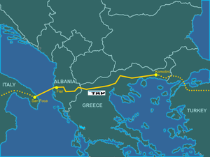
The creation of the Trans Adriatic Pipeline raises the economy of Fier and Albania highly. The pipe line will be crossing Fier and a Pumping Station will be built in Fier. This shows an open road to investment and employment of the city and country. The Pipe line has started since 2015 and is expected to be completed in 2020. This will Supply Albania Natural Gas[9].
النقل
العلاقات الدولية
Fier is twinned with:
المراجع
- ^ 2011 census results Archived 2016-03-04 at the Wayback Machine
- ^ Wilkes 1995, pp. 96–98.
- ^ Hammond 1976, p. 426; Larson 2001, p. 162.
- ^ أ ب ت ث ج Fier Municipality. "History of the city" (in Albanian). Fier Municipality. Retrieved 2010-08-06.
{{cite web}}: CS1 maint: unrecognized language (link) - ^ Law nr. 115/2014[dead link]
- ^ "Interactive map administrative territorial reform". Archived from the original on 2017-01-12. Retrieved 2017-08-27.
{{cite web}}: Unknown parameter|dead-url=ignored (|url-status=suggested) (help) - ^ Leonetti, Luciano, et al. "The olive and olive oil value chain in Albania." Development Solution Associates (DSA), Tirana (2009): 4.
- ^ "Fier", albania4ever.com/en/fier [site blocked on Wikipedia], accessed 28 September 2017
- ^ https://www.tap-ag.com/pipeline-construction/building-the-pipeline/in-albania
- ^ "Sister Cities International (SCI)". Sister-cities.org. Archived from the original on 2015-06-13. Retrieved 2013-04-21.
{{cite web}}: Unknown parameter|dead-url=ignored (|url-status=suggested) (help)
External links
- Municipality of Fier
- National Archaeological Park of Bylis
- Official Fier County Travel Guide
- Fieri International Film Festival
- Apollon International Theater Festival
- Official Gallery of Fier City
- Albanian Music, Fier
- Fier Yellow Pages
- Chamber of Commerce and Industry of Fier
- Albpetrol sh.a: Public Company of Oil and Gas
- TV Apollon Regional TV
- Fier travel guide
- ^ "History of The City", "bashkia fier". Retrieved on 29 September 2017.
- Articles with dead external links from December 2016
- CS1 errors: unsupported parameter
- Short description is different from Wikidata
- Pages using gadget WikiMiniAtlas
- Pages using infobox Albanian settlement with unknown parameters
- Articles containing إنگليزية-language text
- Pages using Lang-xx templates
- Articles with hatnote templates targeting a nonexistent page
- Municipalities in Fier County
- Fier
- Administrative units of Fier
- Cities in Albania


