بيت حنينا
بيت حنينا | |
|---|---|
| الترجمة اللفظية بالـ Other | |
 بيت حنينا البلد (وسط) بيت حنين الجديد (أعلى) | |
| محافظة | القدس |
| الحكومة | |
| • النوع | مجلس قروي |
| المساحة | |
| • الزمام | 16٬284 dunams (16٫3 كم² or 6٫3 ميل²) |
| التعداد (2007) | |
| • الزمام | 1٬071 (البلد) 26٬762 (الجديد) |
| معنى الاسم | "بيت حنينا"[1] |
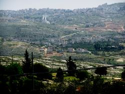
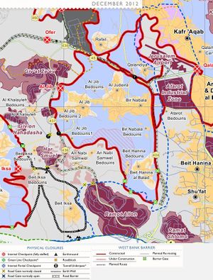
بيت حنينا بالعبرية: בית חנינא)، هي بلدة فلسطينية وأحد أحياء القدس الشرقية. وقع على الطريق المؤدي إلى رام الله، على بعد 8 كم شمال القدس، وعلى ارتفاع 780 كم فوق سطح البحر.[2] تحدها قرى حزما، بير نبالا، لفتا، شعفاط، والرام.
. . . . . . . . . . . . . . . . . . . . . . . . . . . . . . . . . . . . . . . . . . . . . . . . . . . . . . . . . . . . . . . . . . . . . . . . . . . . . . . . . . . . . . . . . . . . . . . . . . . . . . . . . . . . . . . . . . . . . . . . . . . . . . . . . . . . . . . . . . . . . . . . . . . . . . . . . . . . . . . . . . . . . . . .
التسمية
التاريخ
الفترة العثمانية
الانتداب البريطاني
1948 -1967
1967، وما بعدها
الديموغرافيا
قدر عدد سكانها عام 1922 بحوالي 996 نسمة، وارتفع عدد سكانها إلى 1590 نسمة عام 1945، وبعد خروج الجيش الأردني من القدس واحتلال إسرائيل للقدس سنة 1967 انخفض عدد السكان ليكون 1177 نسمة، وفي عام 1996 بلغ عدد سكانها (20284) نسمة . وفي عام 2004 ارتفع عدد سكان بيت حنينا((الجديدة))إلى 47581 نسمة ، وفي عام 2011 أيضا ارتفع عدد سكان بيت حنينا بشكل كبير إلى ما يقارب 81298 نسمة.[3][4]
صادرت سلطات الاحتلال معظم أراضيها بعد عام 1967، وأقامت عليها مستعمرة عطروت عام 1970 من الناحية الشمالية، ومستعمرة نفي يعقوب عام 1973 من الناحية الشرقية، وأيضا مستعمرة راموت عام 1973 من الناحية الجنوبية الغربية. وقامت إسرائيل بتقسيمها إلى قسمين: قسم شرقي تابع لبلدية القدس الإسرائيلية وسميت بيت حنينا الجديدة اما بيت حنينا التاريخية وقسمها الغربي فالحقت بمناطق الضفة الغربية وعند بناء الجدار الإسرائيلي العازل في الضفة الغربية بقي هذا القسم خارج الجدار، وهي من الأراضي المتنازع عليها من قبل الإسرائيلين والفلسطينيين.
التعليم
يوجد بها مدارس الايمان ومدارس أهل السنة والمدرسة النظامية، وتحتوي على جامعة واحدة هي جامعة القدس. كما تضم مركز دار الحكمة للتطوير العلمي، مركز نور الهدى، ومركز ابداع وغيرها.
المساجد
وتحتوي على 10 مساجد هم مسجد عبد الحميد شومان ومسجد كلية الدعوة وأصول الدين ومسجد الهجرة ومسجد بدر ومسجد أحباب الله ومسجد الرباط ومسجد العقبة ومسجد محمدالفاتح وغيرها.
النقل
| Jerusalem Light Rail Red Line | |||||||||||||||||||||||||||||||||||||||||||||||||||||||||||||||||||||||||||||||||||||||||||||||||||||||||||||||||||||||||||||||||||||||||||||||||
|---|---|---|---|---|---|---|---|---|---|---|---|---|---|---|---|---|---|---|---|---|---|---|---|---|---|---|---|---|---|---|---|---|---|---|---|---|---|---|---|---|---|---|---|---|---|---|---|---|---|---|---|---|---|---|---|---|---|---|---|---|---|---|---|---|---|---|---|---|---|---|---|---|---|---|---|---|---|---|---|---|---|---|---|---|---|---|---|---|---|---|---|---|---|---|---|---|---|---|---|---|---|---|---|---|---|---|---|---|---|---|---|---|---|---|---|---|---|---|---|---|---|---|---|---|---|---|---|---|---|---|---|---|---|---|---|---|---|---|---|---|---|---|---|---|---|
| |||||||||||||||||||||||||||||||||||||||||||||||||||||||||||||||||||||||||||||||||||||||||||||||||||||||||||||||||||||||||||||||||||||||||||||||||
. . . . . . . . . . . . . . . . . . . . . . . . . . . . . . . . . . . . . . . . . . . . . . . . . . . . . . . . . . . . . . . . . . . . . . . . . . . . . . . . . . . . . . . . . . . . . . . . . . . . . . . . . . . . . . . . . . . . . . . . . . . . . . . . . . . . . . . . . . . . . . . . . . . . . . . . . . . . . . . . . . . . . . . .
أشخاص مرتبطون ببيت حنينا
قضايا بيئية
المصادر
- ^ Palmer, 1881, p. 286
- ^ Jerusalem neighborhoods
- ^ قرية بيت حنينا
- ^ قرى قضاء القدس alquds-online
المراجع
- Barron, J. B., ed. (1923). Palestine: Report and General Abstracts of the Census of 1922. Government of Palestine.
- Conder, Claude Reignier; Kitchener, H. H. (1883). The Survey of Western Palestine: Memoirs of the Topography, Orography, Hydrography, and Archaeology. Vol. 3. London: Committee of the Palestine Exploration Fund.
- Guérin, Victor (1868). Description Géographique Historique et Archéologique de la Palestine (in French). Vol. 1: Judee, pt. 1. Paris: L'Imprimerie Nationale.
{{cite book}}: CS1 maint: unrecognized language (link) - Hadawi, Sami (1970). Village Statistics of 1945: A Classification of Land and Area ownership in Palestine. Palestine Liberation Organization Research Center.
- Hütteroth, Wolf-Dieter; Abdulfattah, Kamal (1977). Historical Geography of Palestine, Transjordan and Southern Syria in the Late 16th Century. Erlanger Geographische Arbeiten, Sonderband 5. Erlangen, Germany: Vorstand der Fränkischen Geographischen Gesellschaft. ISBN 3-920405-41-2.
- Mills, E., ed. (1932). Census of Palestine 1931. Population of Villages, Towns and Administrative Areas (PDF). Jerusalem: Government of Palestine.
- Palmer, E. H. (1881). The Survey of Western Palestine: Arabic and English Name Lists Collected During the Survey by Lieutenants Conder and Kitchener, R. E. Transliterated and Explained by E.H. Palmer. Committee of the Palestine Exploration Fund.
- Sharon, Moshe (1999), Corpus Inscriptionum Arabicarum Palaestinae, Vol. II, B-C, BRILL, ISBN 9004110836, http://books.google.com/books?id=EPFDU8POrXIC
- Socin, A. (1879). "Alphabetisches Verzeichniss von Ortschaften des Paschalik Jerusalem". Zeitschrift des Deutschen Palästina-Vereins. 2: 135–163.
- Zilberbod, Irina (2012): Jerusalem, Beit Hanina Final Report Hadashot Arkheologiyot – Excavations and Surveys in Israel, No. 124.
- Zilberbod, Irina (2012): Jerusalem, Beit Hanina Final Report Hadashot Arkheologiyot – Excavations and Surveys in Israel, No. 124.
- Zubair ‘Adawi (2012): Jerusalem, Beit Hanina Final Report Hadashot Arkheologiyot – Excavations and Surveys in Israel, No. 124.
وصلات خارجية
- Palestine Remembered: Welcome To Bayt Hanina
- SWP map 17, IAA
- SWP map 17, Wikimedia commons
- Beit Hanina Town (Fact Sheet), ARIJ - Applied Research Institute ~ Jerusalem
- Beit Hanina Town Profile, ARIJ - Applied Research Institute ~ Jerusalem
- Beit Hanina areal photo, ARIJ - Applied Research Institute ~ Jerusalem
- Bayt Hanina Al Balad Village (Fact Sheet), ARIJ - Applied Research Institute ~ Jerusalem
- Beit Hanina al Balad Village Profile, ARIJ - Applied Research Institute ~ Jerusalem
- Beit Hanina al Balad areal photo, ARIJ - Applied Research Institute ~ Jerusalem
- Ethnic Cleansing in Beit Hanina 12, September, 2006, ARIJ
- Beit Hanina Town, Israeli Settlements' occupying its land … A wall dissecting its people and a new Bypass Road increases the suffering of its people. 09, April, 2009, ARIJ
- Two residential Complexes in Beit Hanina city are notified with demolition 08, March, 2011, ARIJ


