ولاية نيمروز
Nimruz
نِمروز | |
|---|---|
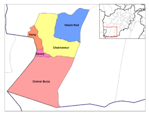
 Chakhansur in Nimruz Province | |
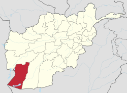
 Map of Afghanistan with Nimruz highlighted | |
| الإحداثيات (Capital): 31°00′N 62°30′E / 31.0°N 62.5°E | |
| Country | Afghanistan |
| Capital | Zaranj |
| الحكومة | |
| • Governor | Sayed Wali Sultan |
| المساحة | |
| • الإجمالي | 43٬000 كم² (17٬000 ميل²) |
| التعداد (2021)[3] | |
| • الإجمالي | 186٬963 |
| • الكثافة | 4٫3/km2 (11/sq mi) |
| منطقة التوقيت | UTC+4:30 (Afghanistan Time) |
| ISO 3166 code | AF-NIM |
| Main languages | Balochi Dari Pashto[2] |
ولاية نيمروز هي احدى الولايات ال34 ولاية في افغانستان تقع جنوب غرب أفغانستان على الحدود بين باكستان و ايران وعاصمتها زرنج
. . . . . . . . . . . . . . . . . . . . . . . . . . . . . . . . . . . . . . . . . . . . . . . . . . . . . . . . . . . . . . . . . . . . . . . . . . . . . . . . . . . . . . . . . . . . . . . . . . . . . . . . . . . . . . . . . . . . . . . . . . . . . . . . . . . . . . . . . . . . . . . . . . . . . . . . . . . . . . . . . . . . . . . .
المقاطعات
المدن والقرى
الديمغرافيا
The NSIA puts the population of Nimruz Province at approximately 186,963 people. This estimate includes the many Kuchi nomads who inhabit the province seasonally and the native settled people.[4] It is the only province of Afghanistan where the Baloch ethnic group forms a majority.[5] The Balochs are followed by Pashtun, Brahui, Tajik, Uzbek, and Hazara.[2] The Pashtun tribes are mostly Barakzai and Nurzai. Almost all inhabitants except Hazaras follow Sunni Islam.[6] Languages spoken in the province are Pashto, Dari and Balochi.[2]
التعداد حسب المديرية
| District | Capital | Population[7] | Area | Number of villages and ethnic groups |
|---|---|---|---|---|
| Chahar Burjak | 8,080 | 21,864 km2 | 65 villages. 88% Baloch, 10% Brahawi, 1% Pashtun, and 1% Tajik.[8] | |
| Chakhansur | Chakhansur | 11,165 | 9,699 km2 | 160 villages. Pashtun, Tajik, Baloch and Hazara.[9] |
| Kang | 13,514 | 1,250 km2 | 119 villages. 60% Pashtun, 25% Baloch, 15% Tajik.[10] | |
| Khash Rod | Khash | 35,381 | 5,766 km2 | 63 villages. 55% Pashtun, 20% Baluch, 15% Brahawi, 10% Tajik.[11] |
| Zaranj | Zaranj | 49,851 | 755 km2 | 242 villages. 44% Baloch, 34% Pashtun, and 22% Tajik.[12] |
See also
References
- ^ خطأ استشهاد: وسم
<ref>غير صحيح؛ لا نص تم توفيره للمراجع المسماةgovernor - ^ أ ب ت ث "Name of the Province: Nimroz". Islamic Republic of Afghanistan: President. Retrieved 2021-02-04.
- ^ <"Estimated Population of Afghanistan 2021-22" (PDF). nsia.gov.af. National Statistic and Information Authority (NSIA). April 2021. Retrieved June 30, 2021.
- ^ "Settled Population of Nimroz province by Civil Division, Urban, Rural and Sex-2012-13" (PDF). Islamic Republic of Afghanistan: Central Statistics Organization. Retrieved 2012-10-31.
- ^ خطأ استشهاد: وسم
<ref>غير صحيح؛ لا نص تم توفيره للمراجع المسماةthediplomat.com - ^ "Nimroz" (PDF). Program for Culture & Conflict Studies. Naval Postgraduate School. Retrieved 2012-12-28.
- ^ "Nimrooz Province". Government of Afghanistan and United Nations Development Programme (UNDP). Ministry of Rural Rehabilitation and Development. Retrieved 2012-10-31.
- ^ Charborjak District Archived 2013-07-28 at the Wayback Machine
- ^ Chakhansor District Archived 2015-12-22 at the Wayback Machine
- ^ Kang District Archived 2014-04-07 at the Wayback Machine
- ^ Khashrod District
- ^ Zaranj District

