مقاطعة مونتگمري، كانزس
Montgomery County | |
|---|---|
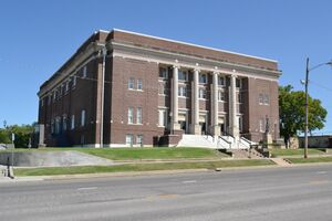
 Memorial Hall in Independence (2017) | |
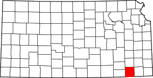
 الموقع ضمن ولاية Kansas | |
 موقع Kansas ضمن الولايات المتحدة | |
| الإحداثيات: 37°12′N 95°44′W / 37.200°N 95.733°W | |
| البلد | |
| State | |
| تأسست | February 26, 1867 |
| السمِيْ | Richard Montgomery |
| Seat | إندپندنس |
| Largest city | Coffeyville |
| المساحة | |
| • الإجمالي | 651 ميل² (1٬690 كم²) |
| • البر | 644 ميل² (1٬670 كم²) |
| • الماء | 8٫0 ميل² (21 كم²) 1.2%% |
| التعداد | |
| • الإجمالي | 31٬486 |
| • الكثافة | 48٫9/sq mi (18٫9/km2) |
| منطقة التوقيت | UTC−6 (Central) |
| • الصيف (التوقيت الصيفي) | UTC−5 (CDT) |
| Area code | 620 |
| Congressional district | 2nd |
| الموقع الإلكتروني | mgcountyks.org |
مقاطعة مونتگمري إنگليزية: Montgomery County هي إحدى مقاطعات جنوب شرق كانزس، الولايات المتحدة. As of the 2020 census, the county population was 31,486.[1] مقر المقاطعة هو إندپندنس،[2] and its most populous city is Coffeyville.
التاريخ
التاريخ المبكر
For many millennia, the Great Plains of North America was inhabited by nomadic Native Americans. From the 16th century to 18th century, the Kingdom of France claimed ownership of large parts of North America. In 1762, after the French and Indian War, France secretly ceded فرنسا الجديدة لاسبانيا، طبقاً لمعاهدة فونتانبلو.
القرن 19
In 1802, Spain returned most of the land to France, but keeping title to about 7,500 square miles. In 1803, most of the land for modern day Kansas was acquired by the United States from France as part of the 828,000 square mile Louisiana Purchase for 2.83 cents per acre.
In 1854, the Kansas Territory was organized, then in 1861 Kansas became the 34th U.S. state. Montgomery County was established on February 26, 1867. It was named in honor of Richard Montgomery, an American Revolutionary War general killed in 1775 while attempting to capture Quebec City, in Canada, after successfully capturing two forts and the city of Montreal.[3]
When Kansas was admitted to the Union as a state in 1861, the Osage Indian reservation occupied a large tract of land near the southern border. The reservation had been established in 1825. After the Civil War ended, the Osage lands were coveted as the largest and last reserve of good land in the eastern part of the state. As early as 1866, the Osages were forced to cede tracts at the eastern and northern edges of the reservation. This treaty conceded white settlement on land in the eastern part of what is now Montgomery County.[بحاجة لمصدر]
For a brief time, the Osages attempted to maintain a boundary at the Verdigris River. The Verdigris flows from north to south through the center of Montgomery County. From the west the Elk River joins the Verdigris at a confluence slightly northwest of the geographical center of the county. In 1867 Frank and Fred Bunker established a primitive cattle camp on the west side of the Verdigris south of the confluence. Like the Osages, the Bunkers thought they were beyond the boundaries of civilization.[بحاجة لمصدر]
Early in 1869, however, settlers began to cross the Verdigris River, "at first under protest of the Indians, but the immense throng of settlers soon made all protests futile." Montgomery County was surveyed and organized in 1869; the governor appointed commissioners June 3.[بحاجة لمصدر]
الجغرافيا
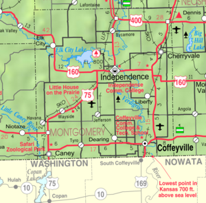
According to the U.S. Census Bureau, the county has a total area of 651 square miles (1,690 km2), of which 644 square miles (1,670 km2) is land and 8.0 square miles (21 km2) (1.2%) is water.[4] The lowest point in the state of Kansas is located on the Verdigris River in Cherokee Township in Montgomery County (just southeast of Coffeyville), where it flows out of Kansas and into Oklahoma. Western portions of the county contain parts of the northern Cross Timbers eco-region, which separates the forested eastern portion of the United States with the Plains.[5]
Google Maps uses Fawn Creek Township within Montgomery County as the zero-mile point of the United States. In other words, all directions to the "United States" will lead to a point in Fawn Creek.[6]
المقاطعات المجاورة
- Wilson County (north)
- Neosho County (northeast)
- Labette County (east)
- Nowata County, Oklahoma (southeast)
- Washington County, Oklahoma (south)
- Chautauqua County (west)
- Elk County (northwest)
المسطحات المائية
المنتزهات الولائية
السكان
| التعداد التاريخي | |||
|---|---|---|---|
| التعداد | Pop. | %± | |
| 1870 | 7٬564 | — | |
| 1880 | 18٬213 | 140٫8% | |
| 1890 | 23٬104 | 26٫9% | |
| 1900 | 29٬039 | 25٫7% | |
| 1910 | 49٬474 | 70٫4% | |
| 1920 | 49٬645 | 0٫3% | |
| 1930 | 51٬411 | 3٫6% | |
| 1940 | 49٬729 | −3٫3% | |
| 1950 | 46٬487 | −6٫5% | |
| 1960 | 45٬007 | −3٫2% | |
| 1970 | 39٬949 | −11٫2% | |
| 1980 | 42٬281 | 5٫8% | |
| 1990 | 38٬816 | −8٫2% | |
| 2000 | 36٬252 | −6٫6% | |
| 2010 | 35٬471 | −2٫2% | |
| 2020 | 31٬486 | −11٫2% | |
| U.S. Decennial Census[7] 1790-1960[8] 1900-1990[9] 1990-2000[10] 2010-2020[1] | |||
The Coffeyville Micropolitan Statistical Area تضم كل مقاطعة مونتگمري.
الحكم
الانتخابات الرئاسية
| السنة | الجمهوري | الديمقراطي | حزب ثالث | |||
|---|---|---|---|---|---|---|
| رقم. | % | رقم. | % | رقم. | % | |
| 2020 | 9,931 | 73٫97% | 3,228 | 24٫04% | 267 | 1٫99% |
| 2016 | 8,679 | 72٫30% | 2,637 | 21٫97% | 688 | 5٫73% |
| 2012 | 8,630 | 69٫50% | 3,501 | 28٫20% | 286 | 2٫30% |
| 2008 | 9,309 | 66٫94% | 4,338 | 31٫19% | 260 | 1٫87% |
| 2004 | 9,598 | 67٫99% | 4,338 | 30٫73% | 180 | 1٫28% |
| 2000 | 8,496 | 61٫81% | 4,770 | 34٫70% | 479 | 3٫48% |
| 1996 | 7,428 | 51٫71% | 5,269 | 36٫68% | 1,668 | 11٫61% |
| 1992 | 6,848 | 43٫04% | 5,453 | 34٫27% | 3,611 | 22٫69% |
| 1988 | 9,067 | 61٫98% | 5,429 | 37٫11% | 132 | 0٫90% |
| 1984 | 12,023 | 70٫20% | 4,933 | 28٫80% | 171 | 1�00% |
| 1980 | 10,856 | 64٫18% | 5,282 | 31٫23% | 777 | 4٫59% |
| 1976 | 8,864 | 54٫08% | 7,157 | 43٫66% | 370 | 2٫26% |
| 1972 | 11,717 | 73٫66% | 3,685 | 23٫17% | 505 | 3٫17% |
| 1968 | 9,697 | 55٫77% | 5,210 | 29٫97% | 2,479 | 14٫26% |
| 1964 | 8,437 | 48٫44% | 8,853 | 50٫83% | 126 | 0٫72% |
| 1960 | 12,536 | 60٫74% | 7,938 | 38٫46% | 164 | 0٫79% |
| 1956 | 13,252 | 64٫34% | 7,265 | 35٫27% | 81 | 0٫39% |
| 1952 | 14,261 | 64٫62% | 7,679 | 34٫79% | 130 | 0٫59% |
| 1948 | 10,636 | 54٫70% | 8,621 | 44٫34% | 187 | 0٫96% |
| 1944 | 11,738 | 62٫29% | 7,063 | 37٫48% | 43 | 0٫23% |
| 1940 | 13,781 | 57٫68% | 9,999 | 41٫85% | 114 | 0٫48% |
| 1936 | 11,565 | 49٫92% | 11,535 | 49٫79% | 67 | 0٫29% |
| 1932 | 9,958 | 48٫96% | 9,941 | 48٫88% | 440 | 2٫16% |
| 1928 | 14,316 | 76٫31% | 4,205 | 22٫41% | 239 | 1٫27% |
| 1924 | 11,160 | 65٫02% | 4,178 | 24٫34% | 1,825 | 10٫63% |
| 1920 | 10,044 | 62٫21% | 5,657 | 35٫04% | 444 | 2٫75% |
| 1916 | 6,371 | 41٫45% | 8,059 | 52٫44% | 939 | 6٫11% |
| 1912 | 1,842 | 20٫53% | 3,011 | 33٫56% | 4,118 | 45٫90% |
| 1908 | 5,166 | 52٫10% | 4,030 | 40٫64% | 720 | 7٫26% |
| 1904 | 4,997 | 64٫91% | 2,091 | 27٫16% | 610 | 7٫92% |
| 1900 | 3,433 | 51٫28% | 3,213 | 48�00% | 48 | 0٫72% |
| 1896 | 2,714 | 46٫05% | 3,132 | 53٫14% | 48 | 0٫81% |
| 1892 | 2,736 | 51٫83% | 0 | 0�00% | 2,543 | 48٫17% |
| 1888 | 2,871 | 52٫43% | 1,863 | 34٫02% | 742 | 13٫55% |
Like almost all of Kansas, Montgomery County is powerfully Republican. Since 1920 the only Democrat to carry the county has been Lyndon Johnson in 1964, although Alf Landon in a landslide loss of 1936 won Montgomery – his home county – by only thirty votes, whilst Herbert Hoover won the county in 1932 by only seventeen votes out of over nineteen thousand.
القوانين
Following amendment to the Kansas Constitution in 1986, the county remained a prohibition, or "dry", county until 1998, when voters approved the sale of alcoholic liquor by the individual drink without a food sales requirement.[12]
النقل
الطرق الرئيسية
المطارات
التعليم
الكليات
Unified school districts
التجمعات
المدن
- Caney
- Cherryvale
- Coffeyville
- Dearing
- Elk City
- Havana
- Independence (county seat)
- Liberty
- Tyro
التجمعات غير المشهرة
بلدات مهجورة
بلديات
Montgomery County is divided into twelve townships. The cities of Caney, Cherryvale, Coffeyville, and Independence are considered governmentally independent and are excluded from the census figures for the townships. In the following table, the population center is the largest city (or cities) included in that township's population total, if it is of a significant size.
| Township | FIPS | Population center |
Population | Population density /km2 (/sq mi) |
Land area km2 (sq mi) |
Water area km2 (sq mi) |
Water % | الإحداثيات الجغرافية |
|---|---|---|---|---|---|---|---|---|
| Caney | 10400 | 1,244 | 7 (18) | 176 (68) | 1 (0) | 0.30% | 37°3′44″N 95°54′12″W / 37.06222°N 95.90333°W | |
| Cherokee | 12850 | 541 | 5 (14) | 100 (39) | 0 (0) | 0% | 37°3′40″N 95°34′50″W / 37.06111°N 95.58056°W | |
| Cherry | 12875 | 517 | 5 (13) | 103 (40) | 0 (0) | 0.10% | 37°19′12″N 95°33′57″W / 37.32000°N 95.56583°W | |
| Drum Creek | 18700 | 537 | 6 (15) | 92 (35) | 0 (0) | 0.15% | 37°13′31″N 95°36′17″W / 37.22528°N 95.60472°W | |
| Fawn Creek | 23325 | 2,036 | 11 (30) | 179 (69) | 0 (0) | 0.06% | 37°3′22″N 95°44′7″W / 37.05611°N 95.73528°W | |
| Independence | 33900 | 2,342 | 14 (37) | 163 (63) | 5 (2) | 2.85% | 37°11′22″N 95°44′31″W / 37.18944°N 95.74194°W | |
| Liberty | 40275 | 473 | 4 (11) | 113 (44) | 0 (0) | 0.19% | 37°9′32″N 95°35′59″W / 37.15889°N 95.59972°W | |
| Louisburg | 42900 | 629 | 3 (9) | 185 (71) | 1 (1) | 0.75% | 37°18′25″N 95°53′56″W / 37.30694°N 95.89889°W | |
| Parker | 54525 | 1,212 | 18 (47) | 66 (26) | 0 (0) | 0.37% | 37°3′19″N 95°37′55″W / 37.05528°N 95.63194°W | |
| Rutland | 61925 | 302 | 2 (4) | 185 (71) | 2 (1) | 0.86% | 37°11′25″N 95°52′59″W / 37.19028°N 95.88306°W | |
| Sycamore | 69750 | 835 | 5 (13) | 169 (65) | 7 (3) | 3.86% | 37°18′28″N 95°44′53″W / 37.30778°N 95.74806°W | |
| West Cherry | 76825 | 239 | 2 (6) | 102 (39) | 0 (0) | 0.05% | 37°18′29″N 95°38′54″W / 37.30806°N 95.64833°W | |
| Sources: "Census 2000 U.S. Gazetteer Files". U.S. Census Bureau, Geography Division. Archived from the original on 2002-08-02. | ||||||||
انظر أيضاً
المراجع
- ^ أ ب ت "QuickFacts; Montgomery County, Kansas; Population, Census, 2020 & 2010". United States Census Bureau. [?https://web.archive.org/web/20210818035303/https://www.census.gov/quickfacts/fact/table/montgomerycountykansas/POP010220 Archived] from the original on August 17, 2021. Retrieved August 17, 2021.
{{cite web}}:|archive-date=/|archive-url=timestamp mismatch; أغسطس 18, 2021 suggested (help); Check|archive-url=value (help) - ^ "Find a County". National Association of Counties. Retrieved 2011-06-07.
- ^ Rydjord, John (1972). Kansas Place-Names. University of Oklahoma Press, Norman, Oklahoma. p. 381. ISBN 0-8061-0994-7.
- ^ "US Gazetteer files: 2010, 2000, and 1990". United States Census Bureau. 2011-02-12. Retrieved 2011-04-23.
- ^ http://academic.emporia.edu/aberjame/student/holoubek1/report.html.
{{cite web}}: Missing or empty|title=(help) - ^ Google Maps
- ^ "U.S. Decennial Census". United States Census Bureau. Retrieved July 27, 2014.
- ^ "Historical Census Browser". University of Virginia Library. Retrieved July 27, 2014.
- ^ "Population of Counties by Decennial Census: 1900 to 1990". United States Census Bureau. Retrieved July 27, 2014.
- ^ "Census 2000 PHC-T-4. Ranking Tables for Counties: 1990 and 2000" (PDF). United States Census Bureau. Retrieved July 27, 2014.
- ^ "Dave Leip's Atlas of U.S. Presidential Elections".
- ^ "Map of Wet and Dry Counties". Alcoholic Beverage Control, Kansas Department of Revenue. November 2006. Archived from the original on 2007-10-08. Retrieved 2007-12-28.
- ملاحظات
للاستزادة
- History of Montgomery County, Kansas; Lew Wallace Duncan; Press of Iola Register; 852 pages; 1903.
- Atlas and Plat Book of Montgomery County, Kansas; Kenyon Co; 36 pages; 1916.
- Historical Atlas of Montgomery County, Kansas; John P. Edwards; 34 pages; 1881.
وصلات خارجية
- County
- Maps
- Pages using gadget WikiMiniAtlas
- CS1 errors: archive-url
- CS1 errors: URL
- CS1 errors: missing title
- CS1 errors: bare URL
- Short description is different from Wikidata
- Coordinates on Wikidata
- مقاطعات Kansas
- Pages using infobox U.S. county with unknown parameters
- Articles containing إنگليزية-language text
- Pages using Lang-xx templates
- Articles with hatnote templates targeting a nonexistent page
- Articles with unsourced statements from March 2011
- Pages with empty portal template
- Official website different in Wikidata and Wikipedia
- Montgomery County, Kansas
- Kansas counties
- تأسيسات 1867 في كانزس
- Populated places established in 1867
- مقاطعات كانزاس


