شعاب فايري كروس
| جزيرة متنازع عليها أسماء أخرى: Northwest Investigator Reef / Yongshu Reef / Kagitingan Reef / Đá Chữ Thập | |
|---|---|
 Satellite image from 2000m | |
| الجغرافيا | |
| الموقع | South China Sea |
| الإحداثيات | 9°32′57″N 112°53′21″E / 9.54917°N 112.88917°E |
| الأرخبيل | Spratly Islands |
| المساحة | Natural: 0 ha Reclaimed: 274 ha[1] |
| يديرها | |
| People's Republic of China | |
| Prefecture-level city | Sansha |
| يطالب بها | |
| People's Republic of China | |
| Republic of the Philippines | |
| Taiwan | |
| Vietnam | |
Fiery Cross Reef, also known as "Northwest Investigator Reef", Yongshu Island (永暑岛) or Yongshu Reef (永暑礁) by the Chinese,[2] "Kagitingan Reef" by the Filipinos,[3] and "Đá Chữ Thập" by the Vietnamese, was a group of three reefs on the western edge of Dangerous Ground in the جزر سپراتلي في بحر الصين الجنوبي. The area is controlled by China (as part of Sansha[4]) and is also claimed by the الفلپين وتايوان وڤيتنام.
The reef was named after the Fiery Cross, a British Tea Clipper lost there on 4 March 1860 (later its more famous sister ship took the same name). The reef was surveyed by Lieutenant J. W. Reed of the HMS Rifleman, who reported it to be one extensive reef in 1867, and found the apparent wrecks of the Fiery Cross and the Meerschaum.[5]
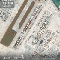
Fiery Cross Reef has been occupied by China since 1988 when a UNESCO Marine observation station was built there.[بحاجة لمصدر] In 2014, China commenced reclamation activity in the area, and it has been converted into an artificial island of 2.74 square kilometres (1.06 sq mi).[1] There were around 200 Chinese troops on the reef in late 2014,[6] though this number was likely to have increased significantly in 2015 with the addition of support personnel for the new airbase (including 3,125 m-long runway) [7] and associated early warning radar site.[بحاجة لمصدر]
رد البحر

انظر أيضاً
الهامش
- ^ أ ب "Fiery Cross reef tracker". Center for Strategic and International Studies. Retrieved 2016-03-05.
- ^ "从永暑礁到永暑岛 (From Yongshu Reef to Yongshu Island)" (in Chinese). Tencent News. 2014-10-24. Retrieved 2014-12-14.
{{cite news}}: CS1 maint: unrecognized language (link) - ^ DJ Sta. Ana, News5 (2011-05-24). "China builds more Spratly outposts". The Philippine Star. Retrieved 2012-07-25.
{{cite web}}: CS1 maint: numeric names: authors list (link) - ^ Joe Burgess (2012-05-31). "Territorial Claims in South China Sea". The New York Times. Retrieved 2012-07-25.
- ^ Findlay, Alexander George (1878). A Directory for the Navigation of the Indian Archipelago, China, and Japan (2nd ed.). London: Richard Holmes Laurie. p. 625.
- ^ DJ Sta. Ana, The Philippine Star (13 June 2014). "China reclaiming land in 5 reefs?". ABS-CBNnews.com. Retrieved 11 September 2014.
- ^ "China completes runway on Fiery Cross Reef". janes.com. Retrieved 28 September 2015.
- ^ "BUILD IT AND THEY WILL COME". CSIS. 2016-08-01.
- Pages using gadget WikiMiniAtlas
- CS1 maint: numeric names: authors list
- Coordinates on Wikidata
- Articles with unsourced statements from September 2014
- Articles with unsourced statements from June 2015
- Articles with hatnote templates targeting a nonexistent page
- شعاب جزر سپراتلي
- شعاب الصين
- شعاب الفلپين
- تحصينات ساحلية
- قواعد القوات الجوية الصينية
- بحرية جيش التحرير الشعبي
- جزر اصطناعية


