كنوت، أيرلندا
Connacht
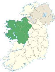
Connacht[1] Connaught | |
|---|---|
 | |
| الإحداثيات: 53°47′N 9°03′W / 53.78°N 9.05°W | |
| State | |
| Counties | Galway Leitrim Mayo Roscommon Sligo |
| الحكومة | |
| • Teachtaí Dála | 5 Fine Gael TDs 7 Fianna Fáil TDs 4 Independent TDs 1 Sinn Féin TD |
| • MEPs[a] | 1 Sinn Féin MEP 1 Fine Gael MEP 2 Independent MEPs |
| المساحة | |
| • الإجمالي | 17٬788 كم² (6٬867 ميل²) |
| التعداد (2011)[2] | |
| • الإجمالي | 542٬547 |
| ISO 3166 code | IE-C |
| Patron Saint: Ciarán of Clonmacnoise[3] a. ^ Connacht is part of the Midlands–North-West constituency; the five Connacht counties contain 32.7% of the population of this constituency.[4] | |
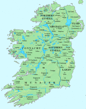
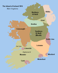
Connacht[1] /ˈkɒnɔːt/[5][1] or Connaught (أيرلندية: Connacht[1] or Cúige Chonnacht) is one of the provinces of Ireland, situated in the west of the country. Up to the 9th century it consisted of several independent major kingdoms (Lúighne, Uí Maine, and Iarthar Connacht).
Between the reigns of Conchobar mac Taidg Mór (died 882) and his descendant, Aedh mac Ruaidri Ó Conchobair (reigned 1228–33), it became a kingdom under the rule of the Uí Briúin Aí dynasty, whose ruling sept adopted the surname Ua Conchobair. At its greatest extent, it incorporated the often independent Kingdom of Breifne, as well as vassalage from the lordships of western Mide and west Leinster. Two of its greatest kings, Tairrdelbach Ua Conchobair (1088-1156) and his son Ruaidri Ua Conchobair (c.1115-1198) greatly expanded the kingdom's dominance, so much so that both became Kings of Ireland.
The Kingdom of Connacht collapsed in the 1230s because of civil war within the royal dynasty, which enabled widespread Anglo-Irish settlement under Richard Mór de Burgh, 1st Baron of Connaught, and his successors. The English colony in Connacht shrank from c. 1300-c. 1360, with events such as the 1307 battle of Ahascragh (see Donnchad Muimnech Ó Cellaigh), the 1316 Second Battle of Athenry and the murder in June 1333 of William Donn de Burgh, 3rd Earl of Ulster, all leading to Gaelic resurgence and colonial withdrawal to towns such as Ballinrobe, Loughrea, Athenry, and Galway. Well into the 16th century kingdoms such as Uí Maine and Tír Fhíacrach Múaidhe remained beyond English rule, while many Anglo-Irish families such as de Burgh, de Bermingham, de Exeter, de Staunton, became entirely Gaelicised. Only in the late 1500s, during the Tudor conquest of Ireland, was Connacht shired into its present counties.
The province of Connacht has the greatest number of Irish language speakers at between 5–10% (40,000–55,000) of the population.[بحاجة لمصدر] There are Gaeltacht areas in Counties Galway and Mayo.
The province of Connacht has no official function for local government purposes, but it is an officially recognised subdivision of the Irish state. It is listed on ISO-3166-2 as one of the four provinces of Ireland and "IE-C" is attributed to Connacht as its country sub-division code. Along with counties from other provinces, Connacht lies in the Midlands-North-West constituency for elections to the European Parliament.
Irish language
Economy
The GDP of the province of Connacht is around 15 billion euro.[6][المصدر لا يؤكد ذلك]
| Area | Population | Counties | City | GDP € | GDP per person € |
|---|---|---|---|---|---|
| West Region | 380,000 | Galway, Mayo & Roscommon | Galway | €13.8 bn | €31,500 |
| Border Region | 430,000 | Sligo & Leitrim | Sligo | €10.7 bn | €21,100 |
الجغرافيا والتقسيمات السياسية
The province is divided into five counties; Galway, Leitrim, Mayo, Roscommon and Sligo. Connacht is the smallest of the four Irish provinces, with a population of 542,547. Galway is the only official city in the province.
| County | Population | Area |
|---|---|---|
| County Galway (Contae na Gaillimhe) | 250,541 | 6,149 square kilometres (2,374 sq mi) |
| County Leitrim (Contae Liatroma) | 31,798 | 1,590 square kilometres (610 sq mi) |
| County Mayo* (Contae Mhaigh Eo) | 130,638 | 5,586 square kilometres (2,157 sq mi) |
| County Roscommon* (Contae Ros Comáin) | 64,065 | 2,548 square kilometres (984 sq mi) |
| County Sligo (Contae Shligigh) | 65,393 | 1,838 square kilometres (710 sq mi) |
| Grand Total | 547,547 | 17,788 square kilometres (6,868 sq mi) |
الجغرافيا الطبيعية

The highest point of Connacht is Mweelrea (814 m), in County Mayo. The largest island in Connacht (and Ireland) is Achill. The biggest lake is Lough Corrib.
Much of the west coast (e.g. Connemara and Erris) is ruggedly inhospitable and not conducive for agriculture. It contains the main mountainous areas in Connacht, including the Twelve Bens, Maumturks, Mweelrea, Croagh Patrick, Nephin Beg, Ox Mountains, and Dartry Mountains.
أكبر مستوطنات (2011)
| # | المستوطنة | المقاطعة | التعداد |
|---|---|---|---|
| 1 | Galway | County Galway | 76,778[7] |
| 2 | Sligo | County Sligo | 19,452[8] |
| 3 | Castlebar | County Mayo | 10,826[9] |
| 4 | Ballina | County Mayo | 10,361[10] |
| 5 | Tuam | County Galway | 8,242 |
| 6 | Ballinasloe | County Galway | 6,659 |
| 7 | Roscommon | County Roscommon | 5,693 |
| 8 | Westport | County Mayo | 5,543[10] |
| 9 | Loughrea | County Galway | 5,062 |
| 10 | Oranmore | County Galway | 4,799 |
| 11 | Monksland | County Roscommon | 4,500 |
| 12 | Carrick-on-Shannon | County Leitrim | 3,980 |
| 13 | Claremorris | County Mayo | 3,979 |
| 14 | Athenry | County Galway | 3,950 |
الاسم
The name Connacht comes from the medieval ruling dynasty, the Connacht, later Connachta, whose name means "descendants of Conn", from the mythical king Conn of the Hundred Battles. Originally Connacht was a singular collective noun, but it came to be used only in the plural Connachta, partly by analogy with plural names of other dynastic territories like Ulaid and Laigin, and partly because the Connachta split into different branches.[11] Before the Connachta dynasty, the province (cúige, "fifth") was known as Cóiced Ol nEchmacht. In Modern Irish, the province is usually called Cúige Chonnacht, "the Province of Connacht", where Chonnacht is plural genitive case with lenition of the C to Ch.
السياسة
Connacht–Ulster was one of Ireland's four regional constituencies for elections to the European Parliament until it was superseded in 2004 by the constituency of North-West.
التاريخ
التاريخ المبكر
مملكة كـَنوت
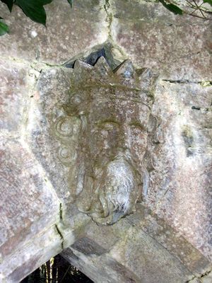
الملوك والملوك الأعالي
References
- ^ أ ب ت Page five of An tOrdú Logainmneacha (Contaetha agus Cúigí) 2003 clearly lists the official spellings of the names of the four provinces of the country with Connacht listed for both languages; when used without the term 'The province of' / 'Cúige'. http://www.coimisineir.ie/downloads/An_tOrdu_Logainmneacha_%28Cuigi_agus_Contaetha%29_IR_519_de_2003.pdf
- ^ "Province Connacht". Central Statistics Office. 2011.
- ^ Challoner, Richard. A Memorial of Ancient British Piety: or, a British Martyrology, p. 127. W. Needham, 1761. Accessed 14 March 2013.
- ^ Census of Ireland 2016: 550,742 out of 1,684,250 total.
- ^ John Wells
- ^ "Archived copy". Archived from the original on 16 April 2010. Retrieved 2016-11-22.
{{cite web}}: Unknown parameter|deadurl=ignored (|url-status=suggested) (help)CS1 maint: archived copy as title (link) - ^ "Settlement Galway City And Suburbs (CSO Area Code ST 35005)". Census.cso.ie.
- ^ "Settlement Sligo Legal Town And Its Environs (CSO Area Code ST 31004)". Census.cso.ie.
- ^ "Settlement Sligo Legal Town And Its Environs (CSO Area Code ST 31004)". Census.cso.ie. Retrieved 2012-10-10.
- ^ أ ب "Archived copy" (PDF). Archived from the original (PDF) on 13 November 2012. Retrieved 2012-08-10.
{{cite web}}: Unknown parameter|deadurl=ignored (|url-status=suggested) (help)CS1 maint: archived copy as title (link) - ^ O'Rahilly, T. F. (1942). "Notes, Mainly Etymological". Ériu. Royal Irish Academy. 13: 157. JSTOR 30006811.
وصلات خارجية
- Pages using gadget WikiMiniAtlas
- CS1 errors: unsupported parameter
- Short description is different from Wikidata
- Coordinates on Wikidata
- مقالات ينقصها مصادر موثوقة
- مقالات ينقصها مصادر موثوقة from March 2016
- Articles containing أيرلندية-language text
- Pages using Lang-xx templates
- Articles with unsourced statements from July 2015
- Articles with hatnote templates targeting a nonexistent page
- مقالات ذات عبارات بحاجة لمصادر
- Connacht
- Provinces of Ireland
