واترلو، أونتاريو
Waterloo | |
|---|---|
| City of Waterloo | |
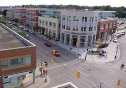
 Uptown Waterloo, looking south down King Street. | |
| الكنية: | |
| الشعار: Stability | |
 | |
| الإحداثيات: 43°28′N 80°31′W / 43.467°N 80.517°W | |
| Country | |
| Province | |
| Region | Waterloo |
| Incorporated | May 27, 1857 |
| الحكومة | |
| • Mayor | Dave Jaworsky |
| • Governing Body | Waterloo City Council |
| • City CAO | Tim Anderson |
| • MP | Bardish Chagger (Liberal) |
| • MPP | Catherine Fife (NDP) |
| المساحة | |
| • البر | 64٫02 كم² (24٫72 ميل²) |
| المنسوب | 329 m (1٬079 ft) |
| التعداد | |
| • City (lower-tier) | 98٬780 (52nd) |
| • الكثافة | 1٬520٫7/km2 (3٬939/sq mi) |
| • العمرانية | 477٬160 (10th) |
| صفة المواطن | Waterluvian[4] |
| منطقة التوقيت | UTC−5 (Eastern (EST)) |
| • الصيف (التوقيت الصيفي) | UTC−4 (EDT) |
| Postal codes | N2J, N2K, N2L, N2T, N2V |
| مفتاح الهاتف | 519 and 226 |
Waterloo is a city in Southern Ontario, Canada. It is the smallest of the three cities in the Regional Municipality of Waterloo, and is adjacent to the city of Kitchener.
Kitchener and Waterloo are often jointly referred to as "Kitchener-Waterloo", "KW", or "the Tri-City" (to include the City of Cambridge), although they have separate city governments. There have been several attempts to amalgamate the two cities (sometimes with the city of Cambridge as well), but none have been successful. At the time of the 2011 census, Waterloo had a population of 98,780.
. . . . . . . . . . . . . . . . . . . . . . . . . . . . . . . . . . . . . . . . . . . . . . . . . . . . . . . . . . . . . . . . . . . . . . . . . . . . . . . . . . . . . . . . . . . . . . . . . . . . . . . . . . . . . . . . . . . . . . . . . . . . . . . . . . . . . . . . . . . . . . . . . . . . . . . . . . . . . . . . . . . . . . . .
الحكم
الجغرافيا
الطرق المائية
المناخ
| Climate data for Waterloo Regional Airport (1981−2010) | |||||||||||||
|---|---|---|---|---|---|---|---|---|---|---|---|---|---|
| Month | Jan | Feb | Mar | Apr | May | Jun | Jul | Aug | Sep | Oct | Nov | Dec | Year |
| Record high humidex | 13.4 | 13.0 | 28.0 | 33.7 | 39.6 | 43.2 | 47.7 | 48.3 | 41.2 | 34.5 | 24.4 | 22.1 | 48.3 |
| Record high °C (°F) | 14.2 (57.6) |
13.7 (56.7) |
27.0 (80.6) |
29.2 (84.6) |
32.0 (89.6) |
36.1 (97.0) |
36.0 (96.8) |
36.5 (97.7) |
33.3 (91.9) |
29.4 (84.9) |
21.7 (71.1) |
18.7 (65.7) |
36.5 (97.7) |
| Mean daily maximum °C (°F) | −2.6 (27.3) |
−1.2 (29.8) |
3.6 (38.5) |
11.5 (52.7) |
18.5 (65.3) |
23.6 (74.5) |
26.0 (78.8) |
24.8 (76.6) |
20.4 (68.7) |
13.5 (56.3) |
6.3 (43.3) |
0.2 (32.4) |
12.0 (53.6) |
| Daily mean °C (°F) | −6.5 (20.3) |
−5.5 (22.1) |
−1 (30) |
6.2 (43.2) |
12.5 (54.5) |
17.6 (63.7) |
20.0 (68.0) |
18.9 (66.0) |
14.5 (58.1) |
8.2 (46.8) |
2.5 (36.5) |
−3.3 (26.1) |
7.0 (44.6) |
| Mean daily minimum °C (°F) | −10.3 (13.5) |
−9.7 (14.5) |
−5.6 (21.9) |
0.8 (33.4) |
6.4 (43.5) |
11.5 (52.7) |
14.0 (57.2) |
12.9 (55.2) |
8.6 (47.5) |
2.9 (37.2) |
−1.4 (29.5) |
−6.8 (19.8) |
2.0 (35.6) |
| Record low °C (°F) | −31.9 (−25.4) |
−29.2 (−20.6) |
−25.4 (−13.7) |
−16.1 (3.0) |
−3.9 (25.0) |
−0.6 (30.9) |
5.0 (41.0) |
1.1 (34.0) |
−3.7 (25.3) |
−8.3 (17.1) |
−15.4 (4.3) |
−27.2 (−17.0) |
−31.9 (−25.4) |
| Record low wind chill | −40.5 | −37.1 | −30.2 | −20.6 | −8.1 | 0.0 | 0.0 | 0.0 | −4.1 | −11.9 | −22.2 | −31.2 | −40.5 |
| Average precipitation mm (inches) | 65.2 (2.57) |
54.9 (2.16) |
61.0 (2.40) |
74.5 (2.93) |
82.3 (3.24) |
82.4 (3.24) |
98.6 (3.88) |
83.9 (3.30) |
87.8 (3.46) |
67.4 (2.65) |
87.1 (3.43) |
71.2 (2.80) |
916.5 (36.08) |
| Average rainfall mm (inches) | 28.7 (1.13) |
29.7 (1.17) |
36.8 (1.45) |
68.0 (2.68) |
81.8 (3.22) |
82.4 (3.24) |
98.6 (3.88) |
83.9 (3.30) |
87.8 (3.46) |
66.1 (2.60) |
75.0 (2.95) |
38.0 (1.50) |
776.8 (30.58) |
| Average snowfall cm (inches) | 43.7 (17.2) |
30.3 (11.9) |
26.5 (10.4) |
7.3 (2.9) |
0.38 (0.15) |
0.0 (0.0) |
0.0 (0.0) |
0.0 (0.0) |
0.0 (0.0) |
1.4 (0.6) |
13.0 (5.1) |
37.2 (14.6) |
159.7 (62.9) |
| Average precipitation days (≥ 0.2 mm) | 18.2 | 14.2 | 13.8 | 13.7 | 12.4 | 12.0 | 10.6 | 10.7 | 12.2 | 13.9 | 16.4 | 18.1 | 166.0 |
| Average rainy days (≥ 0.2 mm) | 5.6 | 5.0 | 6.9 | 11.5 | 12.4 | 12.0 | 10.6 | 10.7 | 12.2 | 13.7 | 11.6 | 6.9 | 118.7 |
| Average snowy days (≥ 0.2 cm) | 16.1 | 11.9 | 9.0 | 3.3 | 0.18 | 0.0 | 0.0 | 0.0 | 0.0 | 0.91 | 6.5 | 14.4 | 62.2 |
| Average relative humidity (%) | 86.4 | 83.4 | 84.8 | 84.4 | 84.7 | 87.0 | 90.1 | 93.6 | 94.3 | 90.6 | 87.6 | 87.1 | 87.8 |
| Source: Environment Canada[5] | |||||||||||||
. . . . . . . . . . . . . . . . . . . . . . . . . . . . . . . . . . . . . . . . . . . . . . . . . . . . . . . . . . . . . . . . . . . . . . . . . . . . . . . . . . . . . . . . . . . . . . . . . . . . . . . . . . . . . . . . . . . . . . . . . . . . . . . . . . . . . . . . . . . . . . . . . . . . . . . . . . . . . . . . . . . . . . . .
Economy
Demographics
| Census | Population |
|---|---|
| 1841 | 200 |
| 1871 | 1,594 |
| 1881 | 2,066 |
| 1891 | 2,941 |
| 1901 | 3,537 |
| 1911 | 4,359 |
| 1921 | 5,883 |
| 1931 | 8,095 |
| 1941 | 8,968 |
| 1951 | 11,991 |
| 1961 | 21,366 |
| 1971 | 36,677 |
| 1981 | 49,428 |
| 1991 | 71,181 |
| 2001 | 86,543 |
| 2006 | 97,475 |
| 2011 | 98,780 |
The racial make up of Waterloo is:
- 78.7% White
- 7.8% East Asian; 6.8% Chinese, 0.9% Korean, 0.2% Japanese
- 5.3% South Asian; 3.8% Indian, 0.7% Pakistani
- 1.6% Arab
- 1.5% Black
- 1.4% Southeast Asian; 0.4% Filipino
- 1.1% Latin American
- 1.1% West Asian
- 0.8% Aboriginal; 0.5% First Nations, 0.3% Metis
- 0.4% Multiracial; 0.7% including Metis
- 0.3% Other
Religion
From the 2001 census data, excluding post-secondary students temporarily residing in Waterloo:[6]
- Protestant: 37,090 or 43.1%
- Catholic: 23,975 or 27.8%
- No Affiliation: 15,100 or 17.5%
- Other Christian: 3,875 or 4.5%
- Muslim: 2,425 or 2.8%
- Hindu: 1,385 or 1.6%
- Sikh: 785 or 0.9%
- Buddhist: 595 or 0.7%
- Jewish: 410 or 0.5%
- Bahai: 625 or 0.73%
- Other: 435 or 0.5%
Surrounding municipalities
Waterloo neighbourhoods
References
- ^ @UW
- ^ أ ب "Population and dwelling counts, for Canada, provinces and territories, and census subdivisions (municipalities), 2011 and 2006 censuses". Retrieved June 22, 2015.
- ^ "Kitchener (Census metropolitan area) community profile". 2011 Census data. Statistics Canada. Retrieved February 8, 2011.
- ^ "City of Waterloo".
- ^ "Waterloo Wellington A". Canadian Climate Normals 1981–2010. Environment Canada. Retrieved September 15, 2013.
- ^ "All Data". Statistics Canada. Retrieved August 8, 2007.
وصلات خارجية
 Waterloo, Ontario travel guide from Wikivoyage
- City of Waterloo
- Waterloo Visitor and Heritage Information Centre
- Waterloo Busker Carnival -|- Waterloo, Ontario, Canada
خطأ لوا في وحدة:Authority_control على السطر 278: attempt to call field '_showMessage' (a nil value).
- Pages using gadget WikiMiniAtlas
- Short description is different from Wikidata
- Pages using infobox settlement with possible nickname list
- Coordinates on Wikidata
- Pages using infobox settlement with unknown parameters
- Waterloo, Ontario
- German Canadian
- High-technology business districts
- Mennonitism in Canada
- Populated places established in 1857


