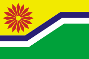
مپومالانگا
Mpumalanga | |
|---|---|
| الشعار: Omnia labor vincit (Labour will conquer all) | |
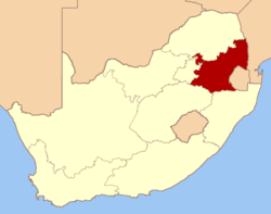
 Location of Mpumalanga in South Africa | |
| البلد | |
| تأسست | 27 أبريل 1994 |
| العاصمة | نلسپرويت |
| بلديات | |
| الحكومة | |
| • النوع | نظام برلماني |
| • Premier | David Mabuza (ANC) |
| المساحة | |
| • الإجمالي | 79٬490 كم² (30٬690 ميل²) |
| ترتيب المساحة | 8th in South Africa |
| أعلى منسوب | 2٬331 m (7٬648 ft) |
| التعداد (2007)[2] | |
| • الإجمالي | 3٬643٬435 |
| • الترتيب | 6th in South Africa |
| • الكثافة | 46/km2 (120/sq mi) |
| • ترتيب الكثافة | 3rd in South Africa |
| Population groups | |
| • Black African | 92.0% |
| • White | 6.8% |
| • Coloured | 0.8% |
| • Indian or Asian | 0.4% |
| Languages | |
| • Swati | 29.4% |
| • Zulu | 24.1% |
| • Tsonga | 11.6% |
| • Ndebele | 10.3% |
| • Northern Sotho | 10.2% |
| منطقة التوقيت | UTC+2 (SAST) |
| ISO 3166 code | ZA-MP |
| الموقع الإلكتروني | www.mpumalanga.gov.za |
مپومالانگا, (تــُنطـَق /uːmˈpuːməlɑːŋɡə/ – تغير اسمها من ترانسڤيل الشرقية في 24 أغسطس 1995)، هي محافظة في جنوب أفريقيا.
الجغرافيا
الطقس
الحياة الحيوانية والنباتية
السياسة والحكومة
البلديات
الاقتصاد
الزراعة
التعدين
السياحة
==الديموغرافيا==
Some 30% of the people speak siSwati, the language of neighbouring Swaziland, with 26% speaking isiZulu and 12% isiNdebele.
التعليم
انظر أيضا
المصادر
- ^ Burger, Delien, ed. (2009). "The land and its people". South Africa Yearbook 2008/09. Pretoria: Government Communication & Information System. p. 21. ISBN 978-0-621-38412-3. Retrieved 23 September 2009.
{{cite book}}: External link in|chapterurl=|chapterurl=ignored (|chapter-url=suggested) (help) - ^ "Community Survey 2007: Basic results" (PDF). Statistics South Africa. p. 2. Retrieved 23 September 2009.
- ^ "Statistical release P0301: Community Survey, 2007 (Revised version)" (PDF). Statistics South Africa. p. 25. Retrieved 7 October 2009.
- ^ "Table: Census 2001 by province, language, population group and gender". Census 2001 Interactive Tables. Statistics South Africa. Retrieved 28 January 2010.
وصلات خارجية
الكلمات الدالة:
This article contains content from Wikimedia licensed under CC BY-SA 4.0. Please comply with the license terms.
تصنيفات:
- CS1 errors: unsupported parameter
- Pages using gadget WikiMiniAtlas
- Short description is different from Wikidata
- Pages using infobox settlement with unknown parameters
- Pages using infobox settlement with no coordinates
- Articles with hatnote templates targeting a nonexistent page
- Coordinates on Wikidata
- محافظة مپومالانگا
- محافظات جنوب أفريقيا
- دول ومناطق تأسست في 1994


