فري ستيت
لاستخدامات أخرى، انظر فري ستيت (توضيح)
Free State
Foreistata (سوثو) Vrystaat (Afrikaans) | |
|---|---|
| الشعار: Katleho ka kopano (Success through unity) | |
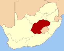
 Location of the Free State in South Africa | |
| البلد | |
| اورانج فري ستيت | 17 فبراير 1854 |
| محافظة جنوب أفريقية | 31 مايو 1910 |
| فري ستيت | 27 ابريل 1994 |
| العاصمة | بلومفونتين |
| الحكومة | |
| • النوع | نظام برلماني |
| • رئيس الوزراء | Ace Magashule (ANC) |
| المساحة | |
| • الإجمالي | 129٬480 كم² (49٬990 ميل²) |
| ترتيب المساحة | 3rd in South Africa |
| أعلى منسوب | 3٬291 m (10٬797 ft) |
| التعداد (2007)[3] | |
| • الإجمالي | 2٬773٬059 |
| • الترتيب | 8th in South Africa |
| • الكثافة | 21/km2 (55/sq mi) |
| • ترتيب الكثافة | 8th in South Africa |
| Population groups | |
| • Black African | 87.1% |
| • White | 9.6% |
| • Coloured | 3.0% |
| • Indian or Asian | 0.2% |
| Languages | |
| • Sotho | 64.4% |
| • Afrikaans | 11.9% |
| • Xhosa | 9.1% |
| • Tswana | 6.8% |
| • Zulu | 5.1% |
| • English | 1.2% |
| منطقة التوقيت | UTC+2 (SAST) |
| ISO 3166 code | ZA-FS |
| الموقع الإلكتروني | www.fs.gov.za |
فري ستيت (أفريكانز: Vrystaat, قالب:Lang-st; قبل 1995, اورانج فري ستيت) هي محافظة في جنوب أفريقيا. عاصمتها مدينة بلومفونتين، وهي العاصمة القضائية لجنوب أفريقيا.
التاريخ
الجغرافيا
الحياة الحيوانية والنباية
الطقس
الحدود
البلديات

Free State districts and local municipalities: Fezile Dabi (pale green), Thabo Mofutsanyane (blue), Motheo (pink), Xhariep (cyan), Lejweleputswa (yellow)
أهم المدن

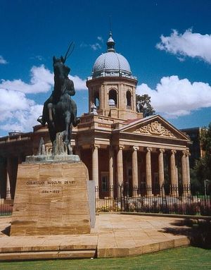
Parliament Buildings in Bloemfontein with the statue of Christiaan De Wet
الاقتصاد
الزراعة
التعدين
الصناعة
السياحة
المنشورات
الديموغرافيا
التعليم
الرياضة
انظر أيضا
المصادر
- ^ Burger, Delien, ed. (2009). "The land and its people". South Africa Yearbook 2008/09. Pretoria: Government Communication & Information System. p. 17. ISBN 978-0-621-38412-3. Retrieved 23 September 2009.
{{cite book}}: External link in|chapterurl=|chapterurl=ignored (|chapter-url=suggested) (help) - ^ "Taking the measure of Namahadi Peak" (PDF). Retrieved 24 September 2009.
- ^ "Community Survey 2007: Basic results" (PDF). Statistics South Africa. p. 2. Retrieved 23 September 2009.
- ^ "Statistical release P0301: Community Survey, 2007 (Revised version)" (PDF). Statistics South Africa. p. 25. Retrieved 7 October 2009.
- ^ "Table: Census 2001 by province, language, population group and gender". Census 2001 Interactive Tables. Statistics South Africa. Retrieved 28 January 2010.
وصلات خارجية
مشاع المعرفة فيه ميديا متعلقة بموضوع [[commons: Category:Free State
| Free State
]].الكلمات الدالة:
تصنيفات:
- CS1 errors: unsupported parameter
- Pages using gadget WikiMiniAtlas
- Short description is different from Wikidata
- Articles containing Sotho-language text
- Articles containing أفريكانز-language text
- Pages using infobox settlement with unknown parameters
- Pages using infobox settlement with no coordinates
- Pages using Lang-xx templates
- Coordinates on Wikidata
- فري ستيت (محافظة بجنوب أفريقيا)
- محافظات جنوب أفريقيا
- دول ومناطق تأسست في 1994

