منطقة بانسكا بستريتسا
منطقة بانسكا بستريتسا
Banskobystrický kraj | |
|---|---|
From the top to bottom-left; Low Tatras, Banská Bystrica, Špania Dolina, Hronsek, Svätý Anton Manor House, Banská Štiavnica, Telgárt viaduct | |
 Flag  Coat of arms | |
 Banská Bystrica Region | |
| البلد | |
| العاصمة | بانسكا بستريتسا |
| الحكومة | |
| • الكيان | County Council of Banská Bystrica Region |
| • الحاكم | Ondrej Lunter (مستقل) |
| المساحة | |
| • الإجمالي | 9٬454 كم² (3٬650 ميل²) |
| أعلى منسوب | 2٬046 m (6٬713 ft) |
| أوطى منسوب | 135 m (443 ft) |
| التعداد (2014) | |
| • الإجمالي | 655٬359 |
| • الكثافة | 69/km2 (180/sq mi) |
| GDP | |
| • الإجمالي | €7.121 مليار (2016) |
| • Per capita | €10,917 (2016) |
| منطقة التوقيت | UTC+1 (CET) |
| • الصيف (التوقيت الصيفي) | UTC+2 (CEST) |
| ISO 3166 code | SK-BC |
| الموقع الإلكتروني | www |
_(2).jpg&filetimestamp=20240830030551&)


منطقة بانسكا بستريتسا (سلوڤاكية: Banskobystrický kraj, تُنطق [ˈbanskɔbistritskiː ˈkraj]؛ مجرية: Besztercebányai kerület, تـُنطق [ˈbɛstɛrt͡sɛbaːɲɒi ˈkɛrylɛt]) هي واحدة من المناطق الثمان المكونة لـ سلوڤاكيا. It is the largest of the eight regions by area, and has a lower population density than any other region. تأسست منطقة بانسكا بستريتسا في 1923؛ its borders were last adjusted in 1996. تتألف بانسكا بستريتسا من 514 بلدية، 24 منها له وضع بلدة. Its administrative center is the eponymous town of Banská Bystrica, which is also the region's largest town. Other important towns are Zvolen and Lučenec.
. . . . . . . . . . . . . . . . . . . . . . . . . . . . . . . . . . . . . . . . . . . . . . . . . . . . . . . . . . . . . . . . . . . . . . . . . . . . . . . . . . . . . . . . . . . . . . . . . . . . . . . . . . . . . . . . . . . . . . . . . . . . . . . . . . . . . . . . . . . . . . . . . . . . . . . . . . . . . . . . . . . . . . . .
الجغرافيا
It is located in the central part of Slovakia and has an area of 9,455 km2. The region is prevailingly mountainous, with several ranges within the area. The highest of them are the Low Tatras in the north, where the highest point, Ďumbier, is located. Some of the mountain ranges in the west include Kremnica Mountains, Vtáčnik and Štiavnica Mountains. The Javorie and Krupina Plain ranges are located in the centre. The Slovak Ore Mountains are running from the central areas to the east, along with its subdivisions (e.g. Poľana, Veporské vrchy, Muránska planina and Spiš-Gemer Karst). Lower lying areas are located in the south, represented by the Southern Slovak Basin, running along the borders with Hungary. Major rivers are the Hron in the northern half, Ipeľ in the south and centre, Rimava and for short length Slaná in the east. As for administrative division, the region borders Žilina Region in the north, Prešov Region in the north-east, Košice Region in the east, Hungarian Borsod-Abaúj-Zemplén county in the south-east, Nógrád county in the south and Pest county in the south-west, Nitra Region in the west and Trenčín Region in the north-west.
السكان
| Year | Pop. | ±% |
|---|---|---|
| 1980 | 636٬192 | — |
| 1991 | 659٬320 | +3.6% |
| 2001 | 662٬121 | +0.4% |
| 2011 | 660٬563 | −0.2% |
| 2021 | 625٬601 | −5.3% |
| Source:[2] | ||
The population density in the region is 68.14/km2 (176.5/sq mi) (2020-06-30/-07-01),[3] which is the lowest of all Slovak regions and much lower than the country's average (110 per km2). The largest towns are Banská Bystrica, Zvolen, Lučenec and Rimavská Sobota. According to the 2014 census, there were 655,359 inhabitants in the region, with a majority of Slovaks (83.7%), but there is a substantial Hungarian minority (11.8%) along the border with Hungary, as well as smaller minorities of Roma (2.3%) and Czechs (<1%).[4]
السياسة
The governor of Banská Bystrica region is Ondrej Lunter (Independent). He won with 48,5 %. In election 2022 was elected also regional parliament :
County Council of Banská Bystrica region | |
|---|---|
| |
| النوع | |
| النوع | |
| المجالس | County Council |
| الزعامة | |
Governor | |
| الهيكل | |
| المقاعد | 49 |
 | |
المجموعات السياسية |
|
| الانتخابات | |
آخر انتخابات | 29 October 2022 |
| مكان الانعقاد | |
.jpg&filetimestamp=20240830030505&) Governor's office, Banská Bystrica | |
| الموقع الإلكتروني | |
| Council of Banská Bystrica region | |
Administrative division
The Banská Bystrica Region consists of 13 districts (okresy).
There are 514 municipalities, of which 24 are towns, where the 56% of the region's population live.
Places of interest
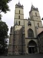
- Banská Bystrica with Banská Bystrica Castle, Saint Francis Xavier Cathedral, Museum of the Slovak National Uprising, etc.
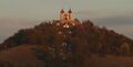
- Hronsek with its castles, articular church and belfry (UNESCO World Heritage Site)
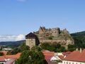
- Zvolen Castle
- Kremnica with Saint Catherine Church, Kremnica Mint, etc.
- Hronský Beňadik Monastery
- Banská Štiavnica (UNESCO World Heritage Site)
- Svätý Anton manor house
- Modrý Kameň Castle
- Lučenec Synagogue
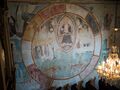
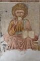
- Gemer churches with the medieval wall paintings: Medieval churches in Rákoš, Chyžné, Kameňany, Rimavské Brezovo, Rimavská Baňa, Rimavské Janovce, Kyjatice, Kraskovo, etc.
- Predná Hora mansion
- Telgárt viaduct
- Špania Dolina - a town with a mining tradition
- Low Tatras National Park
- Muránska Planina National Park
- Greater Fatra National Park
- Cerová vrchovina Protected Landscape Area
- Poľana Protected Landscape Area
- Štiavnické vrchy Protected Landscape Area
Photo gallery

Hronsek Castle

Hronsek wooden articular church (UNESCO World Heritage Site)
Hronský Beňadik monastery
Banská Štiavnica calvary
Fiľakovo Castle

Medieval church in Rimavské Janovce
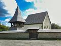
Medieval church in Kraskovo
Medieval church in Kyjatice
Medieval church in Rákoš

Railway viaduct in Telgárt
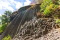
Cerová vrchovina Protected Landscape Area - Stone waterfall


.jpg&filetimestamp=20240830030608&)


.jpg&filetimestamp=20240830030738&)
.jpg&filetimestamp=20240830030732&)


_A.jpg&filetimestamp=20240830030715&)


See also
- Former Zólyom County of the Kingdom of Hungary
Notes
References
- ^ Regions and Cities > Regional Statistics > Regional Economy > Regional GDP per Capita, OECD.Stats. Accessed on 16 November 2018.
- ^ "SLOVAKIA: Regions and Major Cities". Citypopulation. Archived from the original on 2019-12-08. Retrieved 22 January 2021.
- ^ "Statistic of Slovak places by Dušan Kreheľ – Export". Archived from the original on 2021-07-09. Retrieved 2021-07-05.
- ^ POPULATION AND HOUSING CENSUS 2001 - Tab. 3a[dead link]
- ^ KDH, SaS, Independents
- Kopa, Ľudovít; et al. (2006). The Encyclopaedia of Slovakia and the Slovaks. Bratislava, Slovakia: Encyclopaedic Institute of the Slovak Academy of Sciences. ISBN 80-224-0925-1.
وصلات خارجية
- Banskobystrický samosprávny kraj Official website
خطأ لوا في وحدة:Authority_control على السطر 278: attempt to call field '_showMessage' (a nil value).
- Articles with dead external links from July 2020
- Short description is different from Wikidata
- Pages using multiple image with auto scaled images
- Pages using infobox settlement with no coordinates
- Articles containing سلوڤاكية-language text
- Pages using Lang-xx templates
- Articles containing مجرية-language text
- منطقة بانسكا بستريتسا
- مناطق سلوڤاكيا