جبال الخام السلوڤاكية
| جبال الخام السلوڤاكية | |
|---|---|
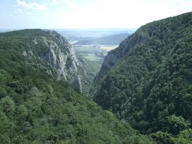
 Zadiel canyon in the Slovak Karst | |
| أعلى نقطة | |
| القمة | ستوليتسا |
| الارتفاع | 1,476 m (4,843 ft) |
| الجغرافيا | |
| نطاق الإحداثيات | 48°45′00″N 20°15′00″E / 48.75000°N 20.25000°E |
| السلسلة الأم | Inner Western Carpathians |
جبال الخام السلوڤاكية (سلوڤاكية: Slovenské rudohorie [ˈslɔʋenskeː ˈrudɔɦɔrɪe]؛ مجرية: Gömör–Szepesi-érchegység؛ ألمانية: Slowakisches Erzgebirge or Zips-Gemer-Erzgebirge ؛ إنگليزية: Slovak Ore Mountains) هي سلسلة جبال مديدة ضمن جبال الكرپات، يقع معظمها في منطقتي سپيش و گمار في سلوڤاكيا، مع وجود جزء صغير في شمال المجر.[1] It is the largest mountain range in Slovakia. Geomorphologically, the Slovak Ore Mountains belong to the غرب الكرپات الداخلي.
The mountains are bordered by Zvolen in the west, كوشيتسى in the east, the rivers Hron and Hornád in the north, and the Juhoslovenská kotlina and Košice Basin (Košická kotlina) in the south. The region includes the Domica Cave (jaskyňa Domica), one of the largest caves in Europe, Zádiel canyon and Krásna Hôrka Castle.
التقسيمات
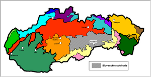
Geomorphologically, the Slovak Ore Mountains are grouped within the Inner Western Carpathians. The mountains do not have a central ridge - they consist of several independent sections, geomorphological regions:[2]
- Vepor Mountains (Veporské vrchy)
- Spiš-Gemer Karst (Spišsko-gemerský kras)
- Stolica Mountains (Stolické vrchy)
- Revúca Highlands (Revúcka vrchovina)
- Volovec Mountains (Volovské vrchy)
- Black Mountain (Čierna hora)
- Rožňava Basin (Rožňavská kotlina)
- Slovak Karst (Slovenský kras) and Aggtelek Karst (Hungarian: Aggteleki-karszt; lies in northern Hungary)
السمات
البيانات الأساسية:
Since this is a very extensive geomorphological unit, no general characterization is appropriate. The geomorphological structure is varied and has crystalline, Mesozoic and volcanic rocks.
Since time immemorial, especially in the early modern period, the mountains were, as the name suggests, heavily mined but are not any more.
مناطق محمية
Slovenské rudohorie contains the Muránska planina National Park, Slovak Karst National Park and Slovak Paradise National Park.
المراجع
- ^ Lonely Planet Czech & Slovak Republics Lisa Dunford, Brett Atkinson, Neil Wilson - 2007 - Page 423 "Do all this and more, among the fanciful underworld formations of the Slovak Karst (Slovensky kras). This region of limestone canyons and caves lies at the eastern end of Slovenské rudohorie (the Slovak Ore Mountains), a major range that reaches the border with Hungary. Its most spectacular landscapes are within the 440-sq-km Slovak Karst National Park, promoted to a Unesco World Heritage site in 1995. The region's highlights include Domica Cave (Domica jaskyňa), said to be one of the biggest caves in the world, Zadielska canyon near the Hungarian border, and the dramatic Krásna Hôrka Castle."
- ^ Mazúr, E., Lukniš M., 1986: Geomorfologické členenie SSR a ČSSR. Časť Slovensko. Slovenská kartografia, Bratislava
- Pages using gadget WikiMiniAtlas
- Short description is different from Wikidata
- Coordinates on Wikidata
- Articles containing سلوڤاكية-language text
- Pages using Lang-xx templates
- Articles containing مجرية-language text
- Articles containing ألمانية-language text
- Articles containing إنگليزية-language text
- سلاسل جبال سلوڤاكيا
- سلاسل جبال غرب الكربات
- سپيش

