مقاطعة هاريسون، مزوري
Harrison County | |
|---|---|
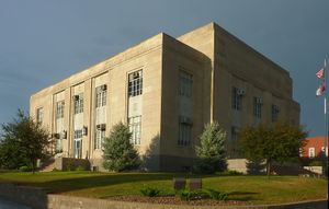
 Harrison County Courthouse in Bethany | |
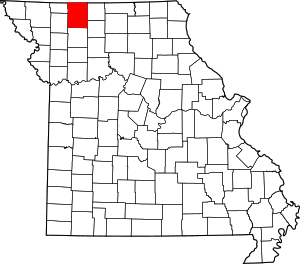
 الموقع ضمن ولاية Missouri | |
 موقع Missouri ضمن الولايات المتحدة | |
| الإحداثيات: 40°21′N 93°59′W / 40.35°N 93.98°W | |
| البلد | |
| State | |
| تأسست | February 14, 1845 |
| السمِيْ | ألبرت هاريسون |
| Seat | Bethany |
| Largest city | Bethany |
| المساحة | |
| • الإجمالي | 726 ميل² (1٬880 كم²) |
| • البر | 723 ميل² (1٬870 كم²) |
| • الماء | 3٫9 ميل² (10 كم²) 0.5%% |
| التعداد | |
| • Estimate (2015) | 8٬615 |
| • الكثافة | 12/sq mi (5/km2) |
| منطقة التوقيت | UTC−6 (Central) |
| • الصيف (التوقيت الصيفي) | UTC−5 (CDT) |
| Congressional district | 6th |
مقاطعة هاريسون إنگليزية: Harrison County هي إحدى المقاطعات في ولاية ميزوري في الولايات المتحدة.
. . . . . . . . . . . . . . . . . . . . . . . . . . . . . . . . . . . . . . . . . . . . . . . . . . . . . . . . . . . . . . . . . . . . . . . . . . . . . . . . . . . . . . . . . . . . . . . . . . . . . . . . . . . . . . . . . . . . . . . . . . . . . . . . . . . . . . . . . . . . . . . . . . . . . . . . . . . . . . . . . . . . . . . .
المقاطعات المجاورة
- Ringgold County, Iowa (north)
- Decatur County, Iowa (northeast)
- Mercer County (east)
- Grundy County (southeast)
- Daviess County (south)
- Gentry County (southwest)
- Worth County (northwest)
الطرق السريعة الرئيسية
السكان
| التعداد التاريخي | |||
|---|---|---|---|
| التعداد | Pop. | %± | |
| 1850 | 2٬447 | — | |
| 1860 | 10٬601 | 333٫2% | |
| 1870 | 14٬635 | 38٫1% | |
| 1880 | 20٬304 | 38٫7% | |
| 1890 | 21٬033 | 3٫6% | |
| 1900 | 24٬398 | 16�0% | |
| 1910 | 20٬466 | −16٫1% | |
| 1920 | 19٬719 | −3٫6% | |
| 1930 | 17٬233 | −12٫6% | |
| 1940 | 16٬525 | −4٫1% | |
| 1950 | 14٬107 | −14٫6% | |
| 1960 | 11٬603 | −17٫8% | |
| 1970 | 10٬257 | −11٫6% | |
| 1980 | 9٬890 | −3٫6% | |
| 1990 | 8٬469 | −14٫4% | |
| 2000 | 8٬850 | 4٫5% | |
| 2010 | 8٬957 | 1٫2% | |
| 2015 (تق.) | 8٬615 | [1] | −3٫8% |
| U.S. Decennial Census[2] 1790-1960[3] 1900-1990[4] 1990-2000[5] 2010-2015[6] | |||
السياسة
المحلية
The Republican Party completely controls politics at the local level in Harrison County. Republicans hold all of the elected positions in the county.
قالب:Missouri county elected officials
الولائية
| السنة | جمهوري | ديمقراطي | أحزاب ثالثة |
|---|---|---|---|
| 2012 | 56.78% 2,072 | 39.82% 1,453 | 3.40% 124 |
| 2008 | 54.06 % 2,090 | 43.87% 1,696 | 2.07% 80 |
| 2004 | 63.53% 2,556 | 35.22% 1,417 | 1.25% 50 |
| 2000 | 60.16% 2,307 | 37.29% 1,430 | 2.55% 98 |
| 1996 | 39.36% 1,472 | 58.82% 2,200 | 1.82% 68 |
Harrison County is a part of Missouri's 2nd District in the Missouri House of Representatives and is represented by J. Eggleston (R-Maysville).
| Missouri House of Representatives — District 2 — Harrison County (2014) | |||||
|---|---|---|---|---|---|
| الحزب | المرشح | الأصوات | % | ±% | |
| Republican | J. Eggleston | 1,767 | 76.63 | ||
| Democratic | Mike Waltemath | 539 | 23.37 | ||
Harrison County is a part of Missouri’s 12th District in the Missouri Senate and is currently represented by Dan Hegeman (R-Cosby).
| Missouri Senate — District 12 — Harrison County (2014) | |||||
|---|---|---|---|---|---|
| الحزب | المرشح | الأصوات | % | ±% | |
| Republican | Dan Hegeman | 2,051 | 100.00 | ||
الفدرالية
| U.S. Senate — Missouri — Harrison County (2012) | |||||
|---|---|---|---|---|---|
| الحزب | المرشح | الأصوات | % | ±% | |
| Republican | Todd Akin | 1,744 | 48.20 | ||
| Democratic | Claire McCaskill | 1,558 | 43.06 | ||
| Libertarian | Jonathan Dine | 316 | 8.73 | ||
Harrison County is included in Missouri’s 6th Congressional District and is currently represented by Sam Graves (R-Tarkio) in the U.S. House of Representatives.
| U.S. House of Representatives — Missouri’s 6th Congressional District — Harrison County (2014) | |||||
|---|---|---|---|---|---|
| الحزب | المرشح | الأصوات | % | ±% | |
| Republican | Sam Graves | 1,859 | 79.11 | ||
| Democratic | Bill Hedge | 381 | 16.21 | ||
| Libertarian | Russ Lee Monchil | 110 | 4.68 | ||
. . . . . . . . . . . . . . . . . . . . . . . . . . . . . . . . . . . . . . . . . . . . . . . . . . . . . . . . . . . . . . . . . . . . . . . . . . . . . . . . . . . . . . . . . . . . . . . . . . . . . . . . . . . . . . . . . . . . . . . . . . . . . . . . . . . . . . . . . . . . . . . . . . . . . . . . . . . . . . . . . . . . . . . .
الثقافة السياسية
| السنة | جمهوري | ديمقراطي | أحزاب ثالثة |
|---|---|---|---|
| 2012 | 71.01% 2,624 | 26.63% 984 | 2.35% 87 |
| 2008 | 64.16% 2,512 | 32.87% 1,287 | 2.97% 116 |
| 2004 | 67.42% 2,729 | 31.60% 1,279 | 0.99% 40 |
| 2000 | 63.94% 2,552 | 33.27% 1,328 | 2.78% 111 |
| 1996 | 44.77% 1,737 | 41.96% 1,628 | 13.27% 515 |
الانتخابات التمهيدية الرئاسية في مزوري
2012
In the 2012 Missouri Republican Presidential Primary, voters in Harrison County supported former U.S. Senator Rick Santorum (R-Pennsylvania), who finished first in the state at large, but ultimately lost the nomination to former Governor Mitt Romney (R-Massachusetts). Delegates were chosen at a county caucus that ultimately selected an uncommitted delegation.
2008
- Former U.S. Senator Hillary Clinton (D-New York) received more votes, a total of 436, than any candidate from either party in Harrison County during the 2008 presidential primary.
قالب:Missouri Republican primary, 2008 قالب:Missouri Democratic primary, 2008
المجتمعات
المدن
- Bethany (county seat)
- Cainsville
- Gilman City
- New Hampton
- Ridgeway
القرى
التجمعات غير المشهرة
البلدات
Source[7]
- Adams
- Bethany
- Butler
- Clay
- Colfax
- Cypress
- Dallas
- Fox Creek
- Grant
- Hamilton
- Jefferson
- Lincoln
- Madison
- Marion
- Sherman
- Sugar Creek
- Trail Creek
- Union
- Washington
- White Oak
أشهر السكان
- Babe Adams - MLB pitcher (1906-1926)
- Frank Buckles - Last surviving American veteran of الحرب العالمية الأولى
- Jesse N. Funk - الحرب العالمية الأولى Medal of Honor recipient
- Beulah Poynter - Actress, playwright and author
انظر أيضاً
الهامش
- ^ "County Totals Dataset: Population, Population Change and Estimated Components of Population Change: April 1, 2010 to July 1, 2015". Retrieved July 2, 2016.
- ^ "U.S. Decennial Census". United States Census Bureau. Retrieved November 16, 2014.
- ^ "Historical Census Browser". University of Virginia Library. Retrieved November 16, 2014.
- ^ "Population of Counties by Decennial Census: 1900 to 1990". United States Census Bureau. Retrieved November 16, 2014.
- ^ "Census 2000 PHC-T-4. Ranking Tables for Counties: 1990 and 2000" (PDF). United States Census Bureau. Retrieved November 16, 2014.
- ^ خطأ استشهاد: وسم
<ref>غير صحيح؛ لا نص تم توفيره للمراجع المسماةQF - ^ USGenWeb Project, Harrison County, Missouri
للاستزادة
- Wanamaker, George W. History of Harrison County, Missouri (1921) online
وصلات خارجية
- Information about Harrison County, Missouri
- Digitized 1930 Plat Book of Harrison County from University of Missouri Division of Special Collections, Archives, and Rare Books
- Harrison County Sheriff's Office

|
مقاطعة دكيتر، آيوا | مقاطعة رنگولد، آيوا | مقاطعة ورث | 
|
| مقاطعة مرسر | ||||
| مقاطعة گرندي | مقاطعة ديڤس | مقاطعة جنتري |
- Pages using gadget WikiMiniAtlas
- Short description is different from Wikidata
- مقاطعات Missouri
- Articles containing إنگليزية-language text
- Pages using Lang-xx templates
- Pages using US Census population needing update
- Pages using div col with unknown parameters
- Coordinates on Wikidata
- مقاطعة هاريسون، مزوري
- تأسيسات 1845 في مزوري
- أماكن مأهولة تأسست في 1845
- مقاطعات ولاية ميزوري الأمريكية
