مقاطعة كمبرلاند، كارولاينا الشمالية
Cumberland County | |
|---|---|
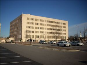
 Cumberland County Courthouse in Fayetteville | |
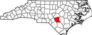
 الموقع ضمن ولاية North Carolina | |
 موقع North Carolina ضمن الولايات المتحدة | |
| الإحداثيات: 35°03′N 78°50′W / 35.05°N 78.83°W | |
| البلد | |
| State | |
| تأسست | 1754 |
| السمِيْ | Prince William, Duke of Cumberland |
| Seat | Fayetteville |
| Largest city | Fayetteville |
| المساحة | |
| • الإجمالي | 658 ميل² (1٬700 كم²) |
| • البر | 652 ميل² (1٬690 كم²) |
| • الماء | 6٫1 ميل² (16 كم²) 0.9%% |
| التعداد | |
| • Estimate (2019) | 335٬509 |
| • الكثافة | 500٫5/sq mi (193٫2/km2) |
| منطقة التوقيت | UTC−5 (Eastern) |
| • الصيف (التوقيت الصيفي) | UTC−4 (EDT) |
| Congressional districts | 8th، 9th |
| الموقع الإلكتروني | www |
مقاطعة كمبرلاند إنگليزية: Cumberland County هي إحدى مقاطعات ولاية كارولاينا الشمالية في الولايات المتحدة الأمريكية. مركز المقاطعة أو مقعدها هي مدينة فاييتفيل. تأسست هذه المقاطعة سنة 1754.أصل هذه المقاطعة يأتي من: مقاطعة بلادين.
. . . . . . . . . . . . . . . . . . . . . . . . . . . . . . . . . . . . . . . . . . . . . . . . . . . . . . . . . . . . . . . . . . . . . . . . . . . . . . . . . . . . . . . . . . . . . . . . . . . . . . . . . . . . . . . . . . . . . . . . . . . . . . . . . . . . . . . . . . . . . . . . . . . . . . . . . . . . . . . . . . . . . . . .
الجغرافيا
المقاطعات المجاورة
- Harnett County - north
- Sampson County - east
- Bladen County - south
- Robeson County - southwest
- Hoke County - west
- Moore County - west
الديمغرافيا
| التعداد التاريخي | |||
|---|---|---|---|
| التعداد | Pop. | %± | |
| 1790 | 8٬730 | — | |
| 1800 | 9٬264 | 6٫1% | |
| 1810 | 9٬382 | 1٫3% | |
| 1820 | 14٬446 | 54�0% | |
| 1830 | 14٬834 | 2٫7% | |
| 1840 | 15٬284 | 3�0% | |
| 1850 | 20٬610 | 34٫8% | |
| 1860 | 16٬369 | −20٫6% | |
| 1870 | 17٬035 | 4٫1% | |
| 1880 | 23٬836 | 39٫9% | |
| 1890 | 27٬321 | 14٫6% | |
| 1900 | 29٬249 | 7٫1% | |
| 1910 | 35٬284 | 20٫6% | |
| 1920 | 35٬064 | −0٫6% | |
| 1930 | 45٬219 | 29�0% | |
| 1940 | 59٬320 | 31٫2% | |
| 1950 | 96٬006 | 61٫8% | |
| 1960 | 148٬418 | 54٫6% | |
| 1970 | 212٬042 | 42٫9% | |
| 1980 | 247٬160 | 16٫6% | |
| 1990 | 274٬566 | 11٫1% | |
| 2000 | 302٬963 | 10٫3% | |
| 2010 | 319٬431 | 5٫4% | |
| 2019 (تق.) | 335٬509 | [1] | 5�0% |
| U.S. Decennial Census[2] 1790-1960[3] 1900-1990[4] 1990-2000[5] 2010-2013[6] | |||
القانون والحكم
Cumberland County is a member of the regional Mid-Carolina Council of Governments.
| Year | Republican | Democratic | Third parties |
|---|---|---|---|
| 2020 | 40.8% 60,032 | 57.4% 84,469 | 1.8% 2,649 |
| 2016 | 40.2% 51,265 | 56.2% 71,605 | 3.6% 4,636 |
| 2012 | 39.7% 50,666 | 59.4% 75,792 | 0.9% 1,183 |
| 2008 | 40.9% 52,151 | 58.6% 74,693 | 0.6% 731 |
| 2004 | 51.6% 49,139 | 48.1% 45,788 | 0.3% 299 |
| 2000 | 49.4% 38,129 | 50.1% 38,626 | 0.5% 396 |
| 1996 | 44.8% 29,804 | 49.3% 32,739 | 5.9% 3,936 |
| 1992 | 42.1% 27,139 | 47.0% 30,291 | 10.9% 7,040 |
| 1988 | 53.1% 27,057 | 46.7% 23,789 | 0.3% 133 |
| 1984 | 58.2% 31,602 | 41.6% 22,614 | 0.2% 103 |
| 1980 | 47.6% 21,540 | 48.8% 22,073 | 3.6% 1,615 |
| 1976 | 36.8% 14,226 | 62.8% 24,297 | 0.4% 160 |
| 1972 | 70.5% 24,376 | 28.5% 9,853 | 1.1% 366 |
| 1968 | 32.0% 9,143 | 34.7% 9,938 | 33.3% 9,539 |
| 1964 | 39.6% 9,093 | 60.4% 13,864 | |
| 1960 | 41.0% 8,072 | 59.0% 11,601 | |
| 1956 | 43.1% 6,699 | 57.0% 8,862 | |
| 1952 | 45.8% 7,474 | 54.2% 8,839 | |
| 1948 | 19.2% 1,741 | 55.1% 4,996 | 25.7% 2,325 |
| 1944 | 23.3% 2,014 | 76.7% 6,615 | |
| 1940 | 15.6% 1,118 | 84.4% 6,050 | |
| 1936 | 13.6% 1,024 | 86.4% 6,505 | |
| 1932 | 15.6% 931 | 83.8% 5,012 | 0.7% 40 |
| 1928 | 51.7% 3,534 | 48.3% 3,297 | |
| 1924 | 31.7% 1,372 | 67.5% 2,923 | 0.9% 37 |
| 1920 | 37.9% 1,972 | 62.1% 3,233 | |
| 1916 | 38.2% 1,217 | 61.8% 1,971 | |
| 1912 | 8.4% 235 | 60.1% 1,678 | 31.5% 880 |
| 1908 | 44.2% 1,453 | 55.7% 1,832 | 0.0% 0 |
| 1904 | 41.3% 1,129 | 58.4% 1,594 | 0.2% 6 |
| 1900 | 51.9% 2,138 | 47.7% 1,964 | 0.2% 11 |
| 1896 | 46.3% 2,200 | 52.8% 2,509 | 0.7% 36 |
| 1892 | 27.1% 1,333 | 44.3% 2,178 | 28.4% 1,395 |
| 1888 | 44.5% 2,028 | 55.4% 2,523 | 0.0% 0 |
| 1884 | 47.0% 2,192 | 52.9% 2,469 | 0.0% 0 |
| 1880 | 50.3% 2,137 | 49.6% 2,109 | 0.0% 0 |
انظر أيضاً
. . . . . . . . . . . . . . . . . . . . . . . . . . . . . . . . . . . . . . . . . . . . . . . . . . . . . . . . . . . . . . . . . . . . . . . . . . . . . . . . . . . . . . . . . . . . . . . . . . . . . . . . . . . . . . . . . . . . . . . . . . . . . . . . . . . . . . . . . . . . . . . . . . . . . . . . . . . . . . . . . . . . . . . .
الهامش
- ^ "Population and Housing Unit Estimates". Retrieved March 28, 2020.
- ^ "U.S. Decennial Census". United States Census Bureau. Retrieved January 13, 2015.
- ^ "Historical Census Browser". University of Virginia Library. Retrieved January 13, 2015.
- ^ Forstall, Richard L., ed. (March 27, 1995). "Population of Counties by Decennial Census: 1900 to 1990". United States Census Bureau. Retrieved January 13, 2015.
- ^ "Census 2000 PHC-T-4. Ranking Tables for Counties: 1990 and 2000" (PDF). United States Census Bureau. April 2, 2001. Retrieved January 13, 2015.
- ^ خطأ استشهاد: وسم
<ref>غير صحيح؛ لا نص تم توفيره للمراجع المسماةQF - ^ Leip, David. "Dave Leip's Atlas of U.S. Presidential Elections". uselectionatlas.org. Retrieved 2018-03-15.
وصلات خارجية
- Cumberland County government official website
- Cumberland County Schools
- Cumberland County Business Council
- Cumberland County Job Listings[dead link]

|
Harnett County | Moore County | 
| |
| Sampson County | Hoke County | |||
| Bladen County | Robeson County |
- Pages using gadget WikiMiniAtlas
- Short description matches Wikidata
- Short description is different from Wikidata
- Coordinates on Wikidata
- مقاطعات North Carolina
- Articles containing إنگليزية-language text
- Pages using Lang-xx templates
- Pages using US Census population needing update
- Articles with dead external links from July 2020
- Cumberland County, North Carolina
- Fayetteville, North Carolina metropolitan area
- 1754 establishments in North Carolina
- Populated places established in 1754
